Segregation
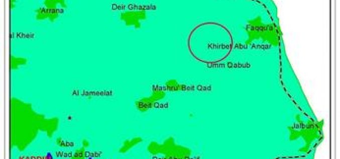
Impact of the Segregation Wall on the Palestinian communities The village of Faqqua strangled by the Wall
Place of violation: The village of Faqqua – Jenin district. Location: The village of Faqqua is located 11 km north east of Jenin adjacent to the green line. See
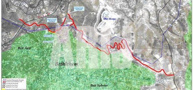
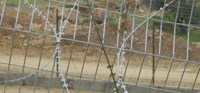
Fencing Beit Jala
The Israeli Occupation Forces IOF closed recently the Occupied Palestinian Territories (OPT) strengthening by that the siege around the Palestinian cities and villages mainly Bethlehem, Abu Dis and
Impact of the Segregation Wall on Jalbun village – Jenin Governorate
Background The village of Jalbun is located 12 km to the east of Jenin city close to the green line. The population of the village is estimated at 2500
Victims of the Israeli Segregation Wall: A Humane Perspective
While calls for unification and open boarders are on the rise, the Israeli occupation forces are fashioning new means to suffocate and repress Palestinians for their so claimed ''security''.
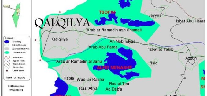
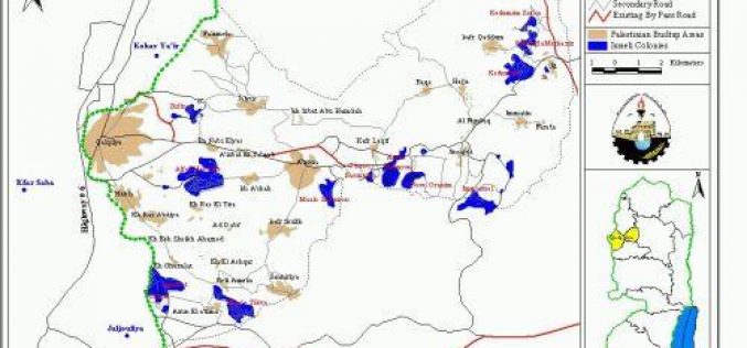
Impact of the Segregation wall on five Palestinian villages in Qalqilya district
Background to the villages The Palestinian neighboring villages of Ras at Tira (400 citizens) and Ad Dab'a (300 citizens) are located 5 km to the east of Qalqilya city.
Jayyous village: a story of human suffering
Since June 2002, the Israeli government decided to commence the construction of the Segregation Wall in the Occupied West Bank. The reason behind this barrier, according to the
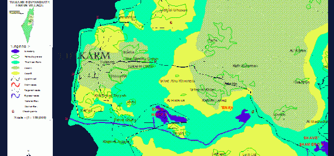
Effects of the Segregation Wall and Israeli military garrison on the Palestinian village of Faro’un / Tulkarm governorate
Background: The village of Faro'un is located 5 km to the south of the city of Tulkarem, with a population of 3000 inhabitants mostly work in agriculture and as
Annexing Rachel’s Tomb: Updated Israeli military order
Arabic_ French_ The southern part of the Segregation Wall The Segregation Wall which is under construction by the Israeli Occupation Forces to surround Jerusalem (the Israeli so-called Jerusalem Envelope) along
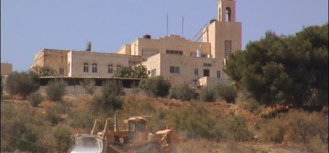
The commencement of circulating the orthodox Housing Project in Beit Sahour
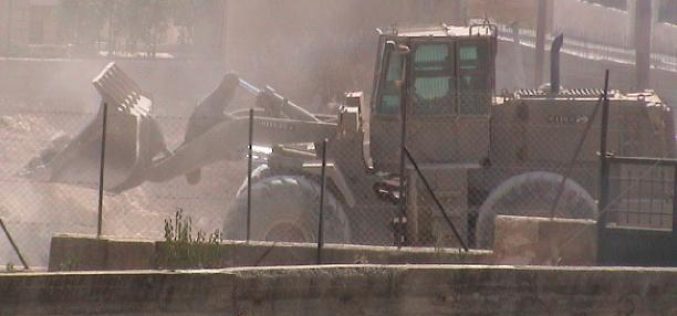
On August 25, 2003 the Israeli bulldozers commenced the construction of the secondary military road that enclaves the Orthodox Housing project in Beit Sahour. Despite the local and international
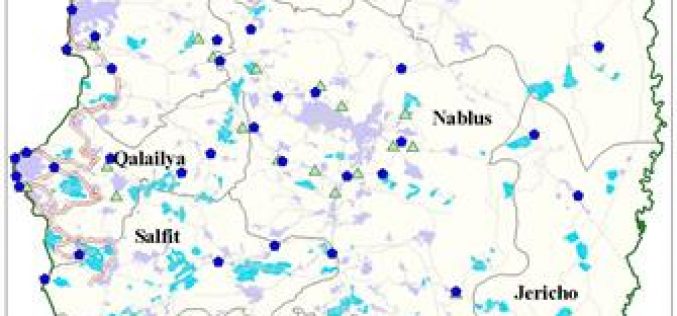
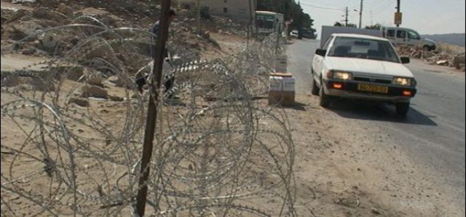
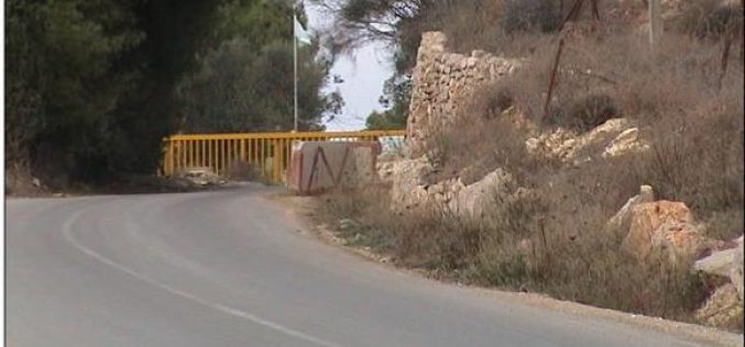
The Israeli Checkpoints in the Northern Districts of the West Bank !!!
For the past two and a half years, the Israeli Occupation Forces erected more than 169 checkpoints and roadblocks all through the main and secondary roads of the West
Baqa Al Sharqia: A Palestinian village isolated by the Segregation Wall
Location: the Palestinian village of Baqa Al Sharqia is located at the northwestern part of the West Bank in Tulkarem governorate. (See Map1) The map shows the Sewgregation
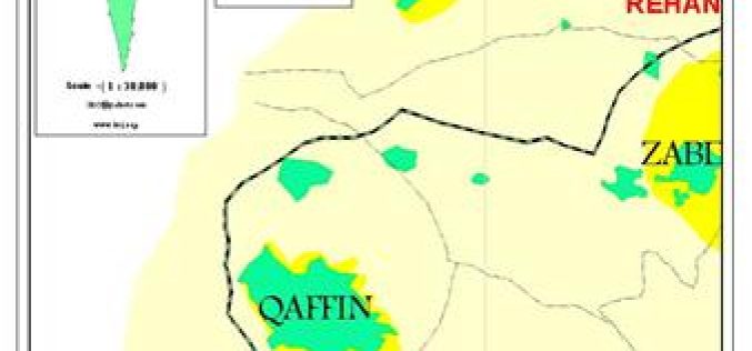
The effects of the Segregation Wall on the Palestinian village of Qaffin
Governorate: Tulkarem Village: Qaffin. Location: it is located 20 km to north of the city of Tulkarem near the green line.( See Map) The map shows the boundaries of
The withdrawal of the Israeli Occupation Forces out of Area A from Bethlehem District
On the second of July, 2003, the Israeli army declared its withdrawal out of area A from Bethlehem district. This act should be clarified as the re-introduction of the
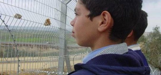
Qalqiliya between the jaws of the Apartheid Wall
Two Palestinian children look through apartheid wall LRC Background Qalqiliya is located in the northern western part of West Bank. It is the smallest Palestinian governorate and the mostly
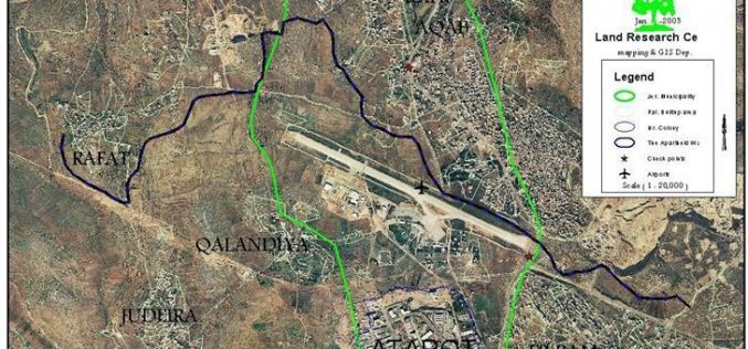
The Map accepted, the Road blocked !
The government of Israel recently accepted the 'Road Map' which calls for normalizing the Palestinian daily life and providing more facilities for the movement in the West Bank in
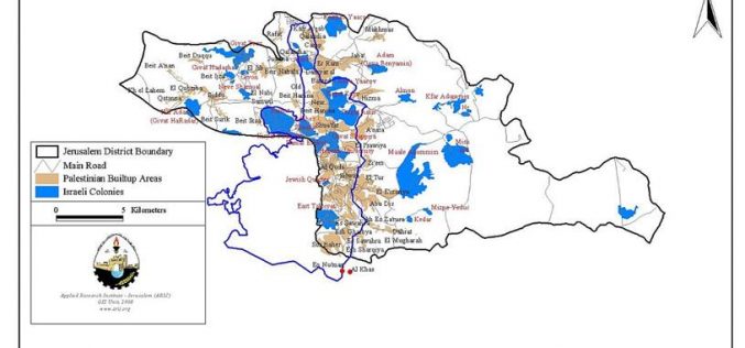
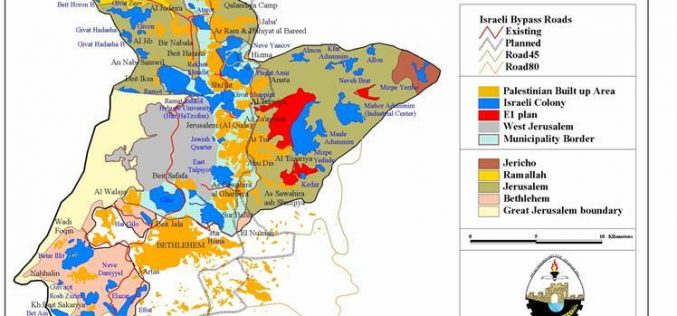
The Segregation Wall… A new Episode of changing Jerusalem Boundaries
Background: Soon after its occupation in 1967, Israel seized control over the Gaza strip and the West Bank including East Jerusalem. Since that time, Israel has either confiscated
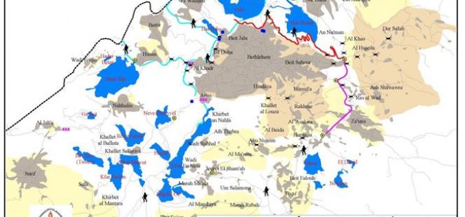
Al-Khas and Al-Nu’man villages between the jaws of occupation
The villages of Al-Khas and Al-Nu'man are located at the interconnection of the municipality borders of Bethlehem, Beit Sahour and Jerusalem. The two villages have about 230 residents,
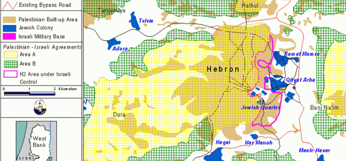
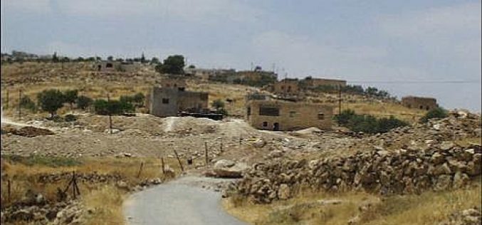
Land theft continues in Hebron
Hebron District is located in the southernmost portion of the West Bank, 36 km south of Jerusalem City with a total population of 405664 and 45 colonial built up areas,
Apartheid Wall … The latest manifestation of the battle for Jerusalem
Background It is no doubt that the Israeli greed in East Jerusalem was put in action only two weeks after the occupation of 1967 when the Israeli government
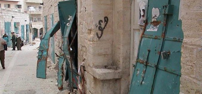
Collective punishment to Bethlehem citizens…!
For the sixth time since the beginning of the Al-Aqsa Intifada, the Israeli occupation forces re-occupied all parts of the Palestinian National Authority area in Bethlehem district on
Flash news about the Apartheid Wall
The Israeli government started recently to construct the Apartheid wall around Jerusalem, which will be 22 Km in length. The wall will separate physically the city of Jerusalem with its
Effects of the Separation Wall
Qalqiliya district at a glance: Qalqiliya district is located to the northwest of the West Bank, and is situated about 12 km from the Mediterranean coast, on the border between
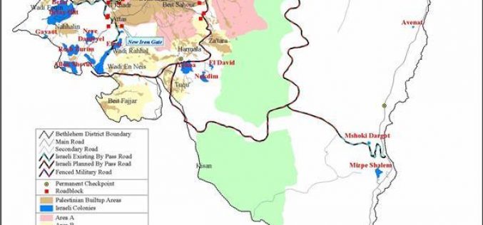
Israeli military Iron Fist squeezes Bethlehem
Bethlehem district is living under apartheid and strangulation as many other Palestinian cities in the West Bank because of the surrounding settlements, bypass roads and checkpoints. The district has been
The Apartheid Wall Campaign
Preface Report # 1 of the Apartheid Wall Campaign is a general look -an introduction- to the Apartheid Wall itself and the Apartheid Wall Campaign, and includes information on the
Israel Blocks The Roads At The Main Entrance Of Bethlehem City Near ARIJ
On the 15th of October 2002 at 1:30 pm the Israeli bulldozers under the protection of Israeli occupation forces started to block the roads at the northern entrance of Bethlehem
