The Israeli Central bureau of Statistics (CBS) published on the 14th of September 2016 statistical data revealing the number of “construction starts” in Israeli settlements in the occupied West Bank (oWB), in Jerusalem (East and West) and in Israel’s proper during the first half of 2016. CBS data showed an increase in the number of “construction starts” in Israeli settlements in the oWB and in Jerusalem in comparison to the year 2015, where during the first half of 2016 (from January to June), construction work started in 1195 settlement units in the occupied West Bank and 2605 others in Jerusalem (East and West Jerusalem).
These numbers constitute an increase of 16.6% in comparison to the same period of 2015, during which 1024 settlement units began to be constructed and an increase of 40.5% in in comparison to the last six months of 2015 (July-December), where work started in 850 settlement units. See Table 1 below
| Table 1: “Construction Starts” in Israeli Settlements in the occupied West Bank during the first six months of 2016 | |||||
| Area | (Jan-June) 2016 | (July – Dec) 2015 | % | (Jan – June) 2015 | (%) from 2016 (Jan-June) |
| West Bank | 1195 | 850 | 40.5 | 1024 | 16.6 |
| Jerusalem | 2605 | 2256 | 15.5 | 2204 | 18.2 |
| (East & West) | |||||
| Total | 3800 | 3106 | —– | 3228 | —– |
| Sources: Israeli Central bureau of Statistics (CBS), 2016 | |||||
Data provided in table 1 comes as “no surprise” to the Palestinians, because regardless of the political affiliation, the successive Israeli Governments have constantly supported and encouraged construction in Israeli settlements and other military installations in the occupied Palestinian territory over the years of the Israeli occupation. To this date, there are more than 763,000 Israeli settlers living in 199 Israeli settlements in the occupied West Bank and East Jerusalem in addition to 232 Israeli outposts and more than 200 military locations (military bases , camps and other training zones).
In related manner, the month of September 2016 witnessed an increase in the number of plans published for expanding settlements. The Israeli ministry of Interior published plans to expand more Israeli settlements in the oPt, with great focus on settlements that have become on the western side of the wall (in what has become known today to the Palestinians by “the western Segregation Zone[1]”). The expansion is to take place in five Israeli settlements, two of which are in Jerusalem Governorate[2], while the remaining four are in the occupied West Bank area. For more details, see table 2
| Table 2: Details of plans published in six Israeli settlements in the occupied West Bank | |||||
| No. | Settlement Name | Plan No. | Date of publish | Area (dunums) | Affected Palestinian Community |
| 1 | Mishor Adumim | יוש/ 23/ 2/ 2/ 2/ 420 | 4/9/2016 | 19.609 | NA |
| 2 | Atarot Industrial Zone | 101-0174946 | 12/9/2016 | 4.292 | NA |
| 3 | Beit Arieh | יוש/ 1/ 1/ 202 | 14/09/2016 | 141.1 | Al Luban |
| 4 | Etz Efrayem | יוש/ 1/ 2/ 126 | 24/08/2016 | 30.28 | Masha |
| 5 | Zufim | יוש/ 7/ 4/ 149 | 17/08/2016 | 1.46 | Jayyus |
| Total | 196.741 | ||||
| Source: Israeli Ministry of Interior, 2016 | |||||
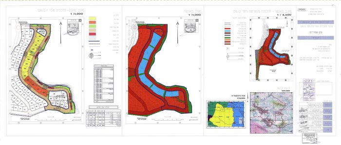
(1) Expansion to take place in Mishor Adumim settlement in Jerusalem Governorate (J2). Expansion comes under plan Number יוש/ 23/ 2/ 2/ 2/ 420 and states an expansion in the settlement’s industrial area by 19.6 dunums. See Photo 1

Photo 1: Israeli TPS No. יוש/ 23/ 2/ 2/ 2/ 420
The Mishor Adumim settlement was established in 1974 on lands of Al Isawiya, At Tur and Al Khan Al Ahmar in Jerusalem Governorate. Today, the settlement occupies a total land area of 3396 dunums and is considered one of the essential Industrial settlements in the occupied West Bank. The settlement includes businesses, food and industrial factories in addition to commercial center. Statistics of 2014 showed that the settlement housed around 300[3] factories and small businesses and two large supermarkets, an art museum and several wineries.
The construction of the Israeli Segregation wall in the occupied West Bank will cause the annexation of the Mishor Adumim and the neighboring settlements (under what Israel calls “the Ma’ale Adumim settlement bloc”,) to Israel, along with two other settlement blocs surrounding Jerusalem city, the “Givat Zeev” settlement bloc in the northwest and the “Gush Etzion” settlement bloc in the southwest. The annexation of the three settlement blocs will affect the geography and the demography of the city of Jerusalem in favor of Israel, as it will cause the exclusion of 12 Palestinian communities (pop +120,000 Palestinians) from the city’s boundary.
(2) The second plan targets the Atarot Industrial Zone (Settlement) in occupied East Jerusalem (J1). It states the construction of a new industrial facility on 4.3 dunums of previously occupied land in the settlement under plan number 101-0174946. See Photo 2

Photo 2: Israeli TPS No. 101-0174946
The Atarot Industrial Zone (Settlement) was established in 1970 on lands of Beit Hanina and Ar Ram communities in occupied East Jerusalem. Today, the settlement is considered the backbone of industry in the occupied West Bank along with some others in the oPt such as Barqan Industrial Zone, Kfar Adumim, Mishor Adumim and Ariel industrial park. The settlement is located in the unilaterally and illegally redrawn Jerusalem Municipality boundary of 1967. Today, the construction of the Israeli Segregation wall around Jerusalem city has engulfed the Atarot Industrial Zone (settlement) to become on the western side of the wall.
Earlier in June 2016, the Israeli Hebrew news website, WALLA[1], reported that the Jerusalem Municipality is promoting the construction of a new and huge settlement neighborhood on the old airport area north of the Atarot industrial Zone (settlement) in occupied East Jerusalem, near Qalandyia village. The article stated that the new neighborhood will include the construction of 15,000 new settlement units in the area. See Map 1

Map 1: Israeli plansi in Mishor Adumim and Atarot settlements
(3) The third plan targets Beit Arye-ofarim settlement in Ramallah Governorate: The Israeli higher planning council of the Israeli Civil Administration has approved plan number יוש/ 1/ 1/ 202 which suggests an update of the distribution of land plots in the settlement and changes in land use in accordance with the approved plan. The land designation comes as part of the Blue line Team land delineation in the oPt. The plan targets 141 dunums already occupied by settlers homes and designate more open area for settlement expansion.
Beit Arye settlement was established in 1981 on lands of Al Luban, Aboud and Deir Ghassanah communities in east Ramallah Governorate. In 2004, the settlement of Beit Arye was merged with Ofarim settlement. Today, both settlements occupy a total land area of 1958 dunums and are home to more than 4500 Israeli settlers. The construction of the Israeli segregation wall in the occupied West Bank has engulfed the Beit Arye-Ofarim settlements west of the wall, with the intention to annex it to Israel’s proper upon wall completion. See Photo 3

Photo 3: Israeli TPS No. יוש/ 1/ 1/ 202
(4) Another expansion activity to see the light in Etz Efrayem Settlement and comes under plan No. יוש/ 1/ 2/ 126 . The plan suggests the designation of 30 dunums of land of Mas-ha village in Qalqilyia Governorate for the settlement’s urban expansion, building new settlement units and roads. The site is undergoing construction today.
Etz Efrayem Settlement was established in the year 1981 on lands of Al Luban, Aboud and Deir Ghassanah communities in Salfit Governorate. Today the settlement occupies a total land area of 1225 dunums and is home to around 600 Israeli settlers. The construction of the Israeli segregation wall in the occupied West Bank has set the settlement of Beit Arye west of the wall with the intention to annex it to Israel’s proper upon wall completion. See Photo 4

Photo 4: Israeli TPS No. יוש/ 1/ 2/ 126
(5) Plan Number יוש/ 7/ 4/ 149 states the confiscation of 1.47 dunums of land of Jayyus village in Qalqilyia Governorate for the expansion of Zufim settlement. See Photo 5

Photo 5: Israeli TPS No. יוש/ 7/ 4/ 149
Note that in August 2016, the Israeli Higher Planning Council of the so-called Israeli Civil Administration (ILA) advertised an announcement in the Palestinian daily newspaper, Al Quds, stating the designation of a new plan for settlement building on lands of Jayyus and Azzun villages northwest of Qalqilyia in the occupied West Bank. The announcement declares the deposit of Town Planning Scheme (TPS) No. 149/10/יוש in Zufim Settlement (Sha’are Tzufim) in Qalqilyia Governorate, in the areas locally known by Kherbit Nofel and Al Thaher Al ‘Awaj.[4] The TPS includes the building of 32 new settlement units on 18.5 dunums of lands of the aforementioned villages.
Zufim settlement was established in 1990 on lands of Azzun and Jayyus villages. Today the settlement occupies an area of 642 dunums of the aforementioned communities and is home to more than 1800 Israeli settlers. To the west of the settlement, there is an Israeli military camp, named Tzufim camp, and administratively follows the settlement of Zufim. The construction of the Israeli Segregation Wall in the occupied West Bank has created an isolation Zone along the western terrains of the West Bank, between the 1949 Armistice Line (Green Line) and the line of the wall. This zone is off access to Palestinians and it engulfs a cluster of Israeli settlements and outposts located in between including Tzufim settlement and the nearby military camp. See Map 2

To sum up,
The existence, expansion and continued building of Israeli settlements in the West Bank have long been recognized as illegal under international law, where each Israeli settlement appropriates land from the Palestinians (often occupying agricultural land, forested areas or open spaces) on which to build.
Israel’s settlement expansion policy in the oPt contradict the well of the international community, re-noting that it’s a de-facto policy come in contradiction with international law, human rights treaties and multiple UN Resolutions.
Article XXXI of the 1995 Oslo agreement; “Neither side shall initiate or take any step that will change the status of the West Bank and the Gaza Strip pending the outcome of the permanent status negotiations’… thereby; Israel is forbidden under this singed binding agreement from all forms of building nor planning any settlements project or any colonial expansion, nor any plan that leads to change the status of the West Bank and Gaza Strip.
Article 49 of the Fourth Geneva Convention relative to the Protection of Civilian Persons in Time of War, August 12, 1949, 6 UST 3516, paragraph 6: “The Occupying Power shall not deport or transfer parts of its own civilian population into the territory it occupies”.
Article 46 of the Hague Convention prohibits the confiscation of private property in occupied territory. The confiscation of land by the Israeli government for settlement construction is in violation of this article. (Laws and Customs of War on Land (Hague II); July 29, 1899).
Article 55 of the Hague Convention stipulates that ‘the occupying state shall be regarded only as administrator and usufructuary of public buildings, real estate, forests, and agricultural estates belonging to the hostile State, and situated in the occupied country. It must safeguard the capital of these properties, and administer them in accordance with the rules of usufruct.’ In other words, the occupying power cannot take over or use territories or private properties in the occupied territories to serve the interests of its civilian population. (Laws and Customs of War on Land (Hague II); July 29, 1899).
The Rome Statute of the International Criminal Court (1998) defines ‘the transfer directly or indirectly by the Occupying power of parts of its own civilian population into the territory it occupies’ as a War Crime indictable by the International Criminal Court. (Article 7, Crimes Against Humanity).
UN Security Council Resolution 465 of 1980 Determines that all measures taken by Israel to change the physical character, demographic composition, institutional structure or status of the Palestinian and other Arab territories occupied since 1967, including Jerusalem, or any part thereof, have no legal validity and that Israel’s policy and practices of settling parts of its population and new immigrants in those territories constitute a flagrant violation of the Fourth Geneva Convention relative to the Protection of Civilian Persons in Time of War and also constitute a serious obstruction to achieving a comprehensive, just and lasting peace in the Middle East.
[1] In the year 2002, the Israeli Government launched its policy of unilateral segregation between Israel and the occupied Palestinian territory (oPt) by establishing a Segregation Zone along the western terrains of the occupied West Bank. The Israeli Government’s pretext to build the wall was to provide security for the people of Israel but the maps that were published on the Israeli ministry of Defense’s web site showed the wall is an interpretation of the long dragged Israeli policy of grabbing Palestinians’ lands as much as possible, before a settlement with the Palestinians is either reached or imposed upon them at a later stage. Upon completion, around 13% of the West Bank’s total area will be isolated within the western terrains of the West Bank and annexed to Israel. Accordingly, 107 Israeli settlements housing more than 85% of the total settlers’ population in the West Bank will be annexed to Israel and around 70 Palestinian communities of more than 300 thousand Palestinians will be set within the western segregation zone and isolated from the neighboring Palestinian communities and the center of life in major cities.
[2] Israeli Settlements in Jerusalem Governorate are classified according to their administrative status: settlements inside the municipal boundary (the J1 area), they are: The Jewish Quarter, Neve Yacoov, Pisgat Ze’ev, Pisgat Amir, Nof Zion, East Telpiot, Atarot Industrial, Ramot Allon, Ramat Shlomo (Rechecs Shu’fat), Rama Eshkol, Hebrew University (Har Hazofim),Giv’at Shapira, Settlers Houses in Jerusalem, Mamilla ,Gilo, Har Homa, Ras Al Amoud (Ma’ale Hazeitim) and Giv’at Hamatos. Settlements within the Jerusalem governorate and outside the municipal boundary (the J2 area), they are: Ma’ale Adumim, Mishor Adumim, Kfar Adumim, Almon (Anatot), Kedar, Mitzpe Yedude, Neve Brat, Allon, Neve Samuel, Har Samuel, Har Adar, Giv’at Ze’ev, Kalya, Roman Bating House, Giv’on Hadasha, Giv’on, Har Adar. Kochav Yacov, Geva’ Benyamin (Adam), Sha’are Benyamin and Mevesert Zion.
[3] מפעלים וחברות
http://www.parkedom.co.il/%D7%9E%D7%A4%D7%A2%D7%9C%D7%99%D7%9D-%D7%95%D7%97%D7%91%D7%A8%D7%95%D7%AA
[4] A new residential neighborhood to see the light in Zufim settlement in Qalqilyia Governorate
http://www.old.poica.org/details.php?Article=9810
Prepared By
The Applied Research Institute – Jerusalem
ARIJ


