Background:
The village of Faro'un is located 5 km to the south of the city of Tulkarem, with a population of 3000 inhabitants mostly work in agriculture and as laborers inside Israel. The village total area is about 8000 dunums, of which 4000 dunums have been confiscated for exclusive Jewish use, including the Segregation Wall.
The village master plan area is about 360 dunums.
The concerned land is located to the west and south east of the village.
The Segregation Wall and army garrison
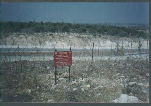
On the first of April, 2002, the Israeli army distributed a written notice in the village streets and fields informing landowners in the village of the Israeli decision to build a separation wall and military garrison on their land. Construction works for the wall started on the same day – the first of April, 2002 – giving landowners no time for objection.
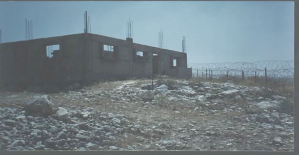
On the other hand, the army started to build the military garrison on 15.7.2003. It is located inside the segregation zone to the west of the wall at a distance of 400 meters from the boundaries of the village master plan.
The garrison has been built on Al -Rahawat Al- Sharqiyah area over 15 dunums of land, 10 of them are classified as village public land and 5 as private land belonging to farmer Ramadan Mohammed Ibrahim. It is worth mentioning that the village public land has been defined by the village council as built up area; besides, The number of affected farmers is over a hundred.
Table 1: Area of confiscated and separated land according to the village council
|
Total area of land confiscated |
1038 dunum |
|
Total area of land bulldozed and trees uprooted |
912 |
|
Total area of land confiscated after amendment of direction of separation wall |
2000 |
|
General total |
3950 |
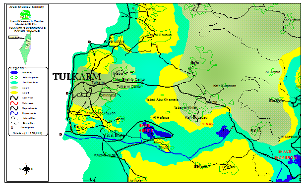
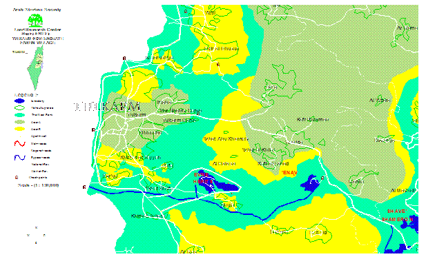
The village of Faro'un to the south of Tulkarem city and Segregation Wall crossing the village land to the west and south.
Map prepared by GIS unit- LRC
Table 2: Information about the land confiscated for the erection of the military garrison:
|
owner name |
Age |
No. of fam. Mem. |
Area in dunum |
Location |
No. of plot |
No. of parcel |
Number & type of cultivation |
|
Ramadan Mohammed Ibrahim |
63 |
10 |
5 |
Rahawat Al Sharqiya |
8474 |
9 |
100 olive trees |
|
Public land |
– |
– |
10 |
Rahawat Al Sharqiya |
8474 |
– |
Built up area |
In an interview with LRC field worker, the head of Faro'un village council, Basim Omer, said the following:
''Since a year the village farmers have been deprived of reaching their fields and cultivated land. The Israeli measures of building the separation line are just an introduction to the confiscation of the village land. All the efforts and attempts made by the village community to reach their agricultural land inside the segregation zone have failed as a result of the Israeli refusal and objection''. See photo 1
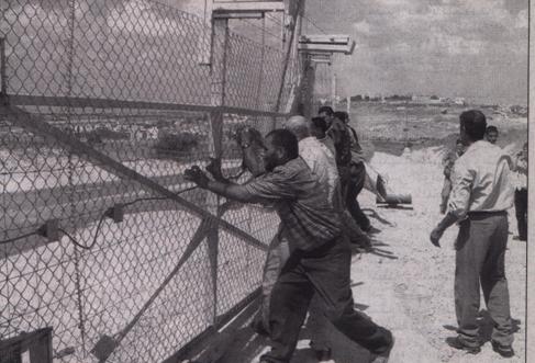
Villagers from Faro'un trying to remove the Segregation wall to reach their besieged land
Photo taken from Al Ayam newspaper
Land status
-
70 % of the land is cultivated with olives.
-
5 % of the land is cultivated with citrus, guava and almond tress.
-
The land confiscated for the erection of the wall was cultivated with olive trees which were completely uprooted. See Photo 2
Olive trees besieged in separation zone are seen in the background
Photo taken by LRC field worker
Previous violations against the land
1. Three years ago the village land was divided into two parts as a result of constructing a bypass road leading to the settlement of Avne Havitz, 5 km to the east of Faro'un village.
2. During the past 3 years, Al- Taibah military checkpoint was pushed 3 km inside the land of Faro'un village within the West Bank proper.
3. Hundreds of dunums of the village land were expropriated and annexed to Israel immediately after the 1967 war.
Distance of confiscated and separated land from the boundaries of the village master plan:
The distance of the Segregation Wall varies from 0.5 meter to 1500 meters from the boundaries of the village master plan, while the newly erected military garrison is about 400 meters away.
There are a number of houses whose distance from the wall is only 0.5 meter. They belong to the following persons:
1. Mr. Jawad Rashad Hasan Issa, See Photo 3

The Segregation Wall travels only half meter from the newly built house of Mr. Jawad Isa
Photo taken by LRC field worker
2. Mr. Farid Abdul Jabar Farekh, See Photo 4
The Segregation Wall passing 5 meters away by the unfinished house of Mr. Farid Farekh
Photo taken by LRC field worker
The aforementioned two houses were recently built and still un- inhabited. The Israeli army prevented its owners from reaching them and threatened to kill any one detected in the vicinity of the two houses. Effects of the wall and military garrison on local people and trade:
The economic effects:
1. The prevention of at least 700 village workers from reaching their workplaces inside the green line, which, in turn, reduced income and standard of living in the village.
2. The uprooting of more than 3000 olive trees.
3. The increase of unemployment amongst village workers to the level of 50%.
4. The decrease of nutrition level, particularly amongst children, resulting from high level of unemployment and low income.
Second: the social effects:
1. An increase in the level of tension among village inhabitants, especially children, who find themselves in direct and daily touch with Israeli military patrols constantly wandering in the area.
2. As a result of loosing land, quite many farmers have ceased to be farmers and went to other jobs.
Prepared by
The Land Research Center
LRC