• About The Project
  • Palestine in Century
  • Selected Maps
  • Glossary
  • About ARIJ
  • About LRC
  • By Year
    • Case Studies By Year
    • Daily Report By Year
Monday, November 9, 2026
POICA
No Result
View All Result
  • Home
  • Settlements
    • New Israeli Settlements
    • Settlement Expansion
  • Israeli Violations
    • Agriculture
    • Confiscation
    • Demolition
    • Environment
    • Eviction of Palestinians
    • Settlers Attacks
  • Bypass Roads
  • Israeli Plans
  • Segregation
    • Checkpoints
    • Closure
    • Separation Plans
  • Military Orders
  • Reports
    • Daily Report
    • Monthly Report
    • Quarterly Report
  • Home
  • Settlements
    • New Israeli Settlements
    • Settlement Expansion
  • Israeli Violations
    • Agriculture
    • Confiscation
    • Demolition
    • Environment
    • Eviction of Palestinians
    • Settlers Attacks
  • Bypass Roads
  • Israeli Plans
  • Segregation
    • Checkpoints
    • Closure
    • Separation Plans
  • Military Orders
  • Reports
    • Daily Report
    • Monthly Report
    • Quarterly Report
No Result
View All Result
POICA
No Result
View All Result

Colonial Scheme to Expand “Tel Manshiya” colony on Umm Ar-Rihan lands / North Jenin

August 15, 2022
in Settlement Expansion
Colonial Scheme to Expand “Tel Manshiya” colony on Umm Ar-Rihan lands / North Jenin

ROWE


The Israeli Occupation Authorities Ratified a colonial scheme to expand Tel Manshiya colony on confiscated lands in Jenin Governorate, North the West Bank.

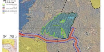
Thursday, July 28th 2022, the colonization subcommittee published a post that approved licensing an organizational plan numbered (3/6/166), which will be activated in two weeks after serving the notice.

Israeli Settlement Plan numbered (3/6/166)

The scheme has a total area of (105 dunums), and will install (107 colonial units) on ‘Anin and Ya’od towns, the scheme will devour a part of natural block number 2 of Ya’abad town lands , and parts of natural block number (6) in Khallet Salih of ‘Anin town.

According to the plan , the new colonial block will be at the northeast of Tel Manshiya colony , it composes of buildings type (Residential A) on a total area of (28 dunums) , residences type (Residential B) on a total area of (9 dunums) , open public area on a total of 53 dunums) and a new colonial road on an area of 12 dunums.

After analyzing the plan , it will obviously eat up Umm Ar-Rihan forest which is annexed by the Annexation and Expansion Wall, in this plan the Israeli government changed allocation of these lands from agricultural lands and forests to construction areas.

Umm Ar-Rihan forest has a total area of (15 thousand dunums) has a distinguished environmental significance, it is a part of Umm Ar-Rihan lands which is blocked by the Annexation and Expansion Wall , and construction is not permitted for Palestinians at this area, while illegal colonies get support from the Israeli Government to expand and develop . And at the time Palestinians do not get licenses to build at the area, and any new constructions are quickly demolished by the Israeli occupation, Colonists supported by the Israeli government build large and expensive buildings.


Prepared by
 The Land Research Center
LRC

Recommended For You

Approval of a Major Expansion Plan for the Tekoa Settlement East of Bethlehem

by arij
September 1, 2026
0
Approval of a Major Expansion Plan for the Tekoa Settlement East of Bethlehem

Targets ≈6,000 dunams of Palestinian land On July 20, 2026, the so-called “Gush Etzion Settlement Regional Council” in the occupied West Bank approved a large-scale settlement master plan...

Read moreDetails

First Half of 2026
“Israeli Settlement Expansion Targets More Than 22,000 Dunams of Palestinian Land”

by arij
September 2, 2026
0
First Half of 2026  “Israeli Settlement Expansion Targets More Than 22,000 Dunams of Palestinian Land”

  Preface, Israeli settlement construction in the occupied West Bank is one of the  tools used by Israel to consolidate control over Palestinian land and reshape the Palestinian...

Read moreDetails

على ما مساحته 1006.4 دونما من أراضي بلدة يانون
“سلطات الاحتلال الإسرائيلي تشرع بتغيير نفوذ بؤرة استيطانية في الضفة الغربية المحتلة”

by arij
March 14, 2026
0
على ما مساحته 1006.4 دونما من أراضي بلدة يانون  “سلطات الاحتلال الإسرائيلي تشرع بتغيير نفوذ بؤرة استيطانية في الضفة الغربية المحتلة”

في الثاني عشر من شهر شباط من العام 2026, نشر رئيس قسم الاستيطان والتنظيم فيما يسمى "بالإدارة المدنية الإسرائيلية", الذراع الأيمن لحكومة الاحتلال الإسرائيلية اعلانا مفاده " اعلان...

Read moreDetails

حين تتقلص الخريطة: تسارع غير مسبوق في توسّع المستوطنات الإسرائيلية خلال عام 2025

by arij
February 16, 2026
0
حين تتقلص الخريطة: تسارع غير مسبوق في توسّع المستوطنات الإسرائيلية خلال عام 2025

مقدمة: - ان السياسة الاستيطانية الإسرائيلية في الضفة الغربية المحتلة هي واحدة من أكثر القضايا التي تقف عائقا في تحقيق سلام عادل وقابل للحياة في الأراضي الفلسطينية المحتلة....

Read moreDetails

حين يصبح الاستيطان سياسة دولة: 26 ألف وحدة جديدة تهدد الضفة الغربية

by arij
November 27, 2025
0
حين يصبح الاستيطان سياسة دولة: 26 ألف وحدة جديدة تهدد الضفة الغربية

في ظلّ صمتٍ دوليٍّ متزايد، يكشف معهد الأبحاث التطبيقية – القدس (أريج) عن طرح سلطات الاحتلال الإسرائيلي مخططات بناء استيطانية لأكثر من 26 ألف وحدة استيطانية جديدة في...

Read moreDetails
Next Post
Colonial Scheme to Expand “Tel Manshiya” colony on Umm Ar-Rihan lands / North Jenin

مخطط استعماري لتوسعة مستعمرة " تل منشيه" على أراضي غابة أم الريحان شمال جنين

LATEST NEWS

“في خدمة المستوطنات والبؤر الاستيطانية الإسرائيلية”  سلطات الاحتلال تصدر 41 أمرا عسكريا لإنشاء خطوط مياه جديدة

“في خدمة المستوطنات والبؤر الاستيطانية الإسرائيلية”
سلطات الاحتلال تصدر 41 أمرا عسكريا لإنشاء خطوط مياه جديدة

by arij
October 21, 2026
0

........................................................

سلطات الاحتلال الإسرائيلي تستولي على 370 دونما من أراضي أبو ديس بذريعة أملاك حكومية

سلطات الاحتلال الإسرائيلي تستولي على 370 دونما من أراضي أبو ديس بذريعة أملاك حكومية

by arij
September 23, 2026
0

........................................................

سلطات الاحتلال الإسرائيلي تتم رسميا اعداد المخطط الهيكلي للبؤرة الاستيطانية «أفيا» (يتسيف/شديما سابقًا) شرق مدينة بيت ساحور

سلطات الاحتلال الإسرائيلي تتم رسميا اعداد المخطط الهيكلي للبؤرة الاستيطانية «أفيا» (يتسيف/شديما سابقًا) شرق مدينة بيت ساحور

by arij
September 17, 2026
0

........................................................

الاحتلال الإسرائيلي يخصص 1627 دونما لصالح البؤرة الاستيطانية “كيدا ” في محافظة نابلس

الاحتلال الإسرائيلي يخصص 1627 دونما لصالح البؤرة الاستيطانية “كيدا ” في محافظة نابلس

by arij
September 10, 2026
0

........................................................

flag_yellow_lowEU-PfP-Logo

This website and its content were initiated in 1993 by the Applied Research Institute – Jerusalem (ARIJ) and the Land Research Center (LRC) with the support from the European Union up until 2023. Since then, the Applied Research Institute – Jerusalem (ARIJ) has taken over the continued development and maintenance of the website. The views expressed remain solely those of ARIJ) and do not necessarily reflect those of the European Union.

© 2026 Copyright | ARIJ | All Rights reserved.

No Result
View All Result
  • Home
  • Settlements
    • New Israeli Settlements
    • Settlement Expansion
  • Israeli Violations
    • Agriculture
    • Confiscation
    • Demolition
    • Environment
    • Eviction of Palestinians
    • Settlers Attacks
  • Bypass Roads
  • Israeli Plans
  • Segregation
    • Checkpoints
    • Closure
    • Separation Plans
  • Military Orders
  • Reports
    • Daily Report
    • Monthly Report
    • Quarterly Report

© 2026 Copyright | ARIJ | All Rights reserved.