• About The Project
  • Palestine in Century
  • Selected Maps
  • Glossary
  • About ARIJ
  • About LRC
  • By Year
    • Case Studies By Year
    • Daily Report By Year
Saturday, June 6, 2026
POICA
No Result
View All Result
  • Home
  • Settlements
    • New Israeli Settlements
    • Settlement Expansion
  • Israeli Violations
    • Agriculture
    • Confiscation
    • Demolition
    • Environment
    • Eviction of Palestinians
    • Settlers Attacks
  • Bypass Roads
  • Israeli Plans
  • Segregation
    • Checkpoints
    • Closure
    • Separation Plans
  • Military Orders
  • Reports
    • Daily Report
    • Monthly Report
    • Quarterly Report
No Result
View All Result
POICA
No Result
View All Result

Eviction Notice for a plot in “Khallet Hassan” area / Salfit Governorate

February 1, 2022
in Military Orders
إخطار بإخلاء قطعة أرض في منطقة ” خلة حسان” / محافظة سلفيت


  • Violation: Eviction Notice for 5 agricultural dunums.
  • Location: Khallet Hassan – Bidya town / Salfit governorate.
  • Date: December 15th 2021.
  • Perpetrators: Governmental Properties Inspector / The Israeli Civil Administration.
  • Victims: Family of Farmer Kamil Salama.
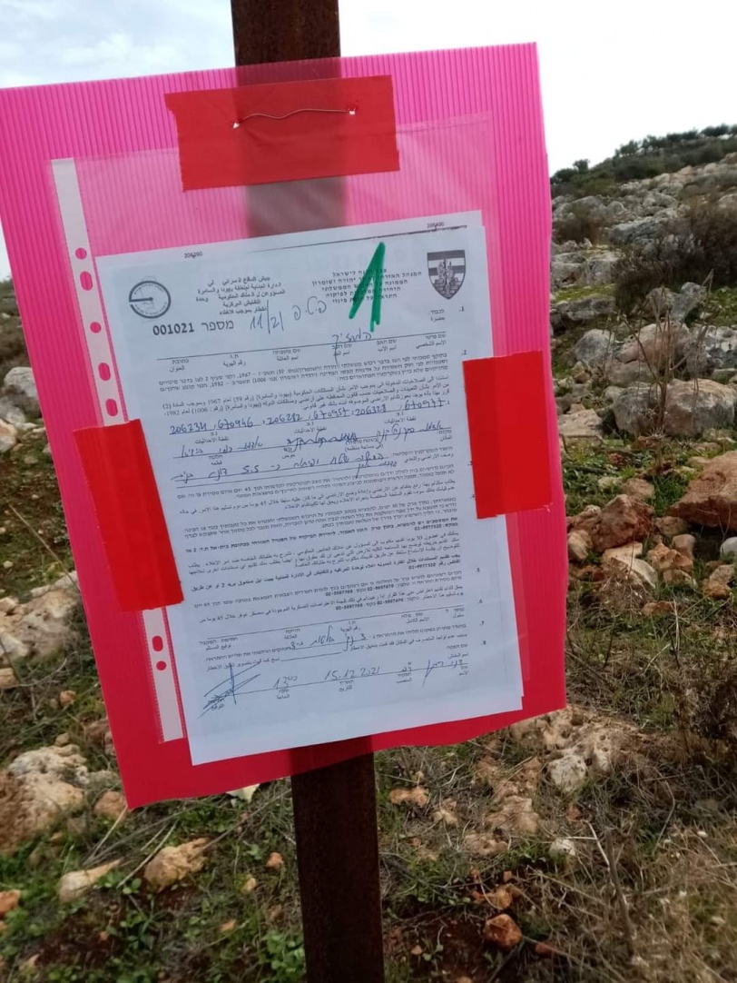
Description:

As part of the occupation’s plan to empty “Khallet Hassan” area to take over it for future colonial expansion, The Israeli Civil Administration served an eviction notice to a plot in Bidya.

Wednesday morning, December 15th 2021, The building inspector at  the Israeli Civil Administration raided Khallet Hassan area , and hanged a military notice on a siege that surrounds a plot with a total area of 5.5 dunums , recently planted with olive trees since march.

Military notice number (1021), orders the owner to evict the plot within 45 days.

The targeted plot belongs to farmer Kamel Yousef Salama from Bidya town north Salfit , and located in natural block 9 of Khallet Hassan.

Khallet Hassan area north Bidya is heavily targeted by Israeli land grabs , an Israeli company took over 1200 dunums , 900 dunums of which were returned to the owners recently following pressures and demonstrations by Human Right organizations on the Israeli government  .

The area is surrounded by many colonies including: Karnei Shamron, Ma’ale Shamron, Novim ,  and Giva’at Yaer , which makes it a hot spot for confiscations.

In addition, The Israeli occupation forces prohibit farmers from planting their own lands, and destroy agricultural projects.

Bidya town:[1]

  • Bidya is located 25 km south east of Nablus city and surrounded by Deir Istiya and
  • Kafr Thulth (north), Seneria , Masha, and Az-Zawiya (west) , Qarawat Bani
    Hussan and Sarta (east), and Kafr Ad-Deek (south).
  • Bidya has a population of (10,451) people according to  2017 census.
  • Bidya has a total area of 13,827 dunums , of which 1,367 dunums are a built
    up area.

The occupation confiscated 637 dunums of its land for the following purpose:

  •  17 donoms were confiscated for the expansion of Ariel” colony from 1999;
  •  620 dunum were seized for the building of   Bypass roads 505 and  5;
  •  The Israeli Occupation is planning to construct a segment of the
    Annexation and Expansion wall on the town’s lands. (the plan is to construct
    a 4118 m segment, which will eat up 411 dunums and isolate 3,690 dunums behind it.

Oslo accords classified the town’s lands as the following:
–    (B) area : 2,045 dunums.
–    (C ) area: 11,782 dunums.


[1] GIS-LRC


Prepared by
 The Land Research Center
LRC

Recommended For You

سلطات الاحتلال الإسرائيلي بصدد الاستيلاء على موقع قبر النبي صموئيل شمال غرب مدينة القدس

by arij
May 23, 2026
0
سلطات الاحتلال الإسرائيلي بصدد الاستيلاء على موقع قبر النبي صموئيل شمال غرب مدينة القدس

 نشرت سلطات الاحتلال الإسرائيلي في الثامن عشر من شهر أيار من العام 2026 اعلانا مفاده الاستيلاء على الأراضي الفلسطينية في قرية النبي صموئيل شمال غرب القدس المحتلة. وجاء...

Read moreDetails

إقامة منطقة عسكرية عسكرية داخل أراضي (أ) في جنين

by arij
May 19, 2026
0
إقامة منطقة عسكرية عسكرية داخل أراضي (أ) في جنين

   في السابع من شهر أيار من العام 2026، وزعت سلطات الاحتلال الإسرائيلي أمرا عسكريا جديدة على أهالي مدينة جنين يقضي بمصادرة 7.2 دونما من الأراضي الفلسطينية في...

Read moreDetails

“بمساحة اجمالية 177 دونما من أرضي البيرة وبيتين”, طريق استيطاني لخدمة البؤر الاستيطانية في محافظة رام الله

by arij
May 18, 2026
0
“بمساحة اجمالية 177 دونما من أرضي البيرة وبيتين”, طريق استيطاني لخدمة البؤر الاستيطانية في محافظة رام الله

في الحادي عشر من شهر أيار من العام 2026, نشرت دائرة أراضي إسرائيل اعلانا جديدا يقضي بمصادرة المزيد من الأراضي الفلسطينية في محافظة رام الله لأغراض استيطانية في...

Read moreDetails

“في خدمة مستوطنة ناحال حيلتس”, طريق استيطاني إسرائيلي جديد على أراضي بتير وبيت جالا في محافظة بيت لحم

by arij
May 18, 2026
0
“في خدمة مستوطنة ناحال حيلتس”, طريق استيطاني إسرائيلي جديد على أراضي بتير وبيت جالا في محافظة بيت لحم

تواصل سلطات الاحتلال الإسرائيلي إحكام سيطرتها على المزيد من الأراضي الفلسطينية في الضفة الغربية المحتلة، وهذه المرة من خلال استهداف أراضي محافظة بيت لحم. ففي السادس والعشرين من...

Read moreDetails

مناطق نفوذ المستوطنات ودورها في إعادة تشكيل الجغرافيا الفلسطينية

by arij
April 23, 2026
0
مناطق نفوذ المستوطنات ودورها في إعادة تشكيل الجغرافيا الفلسطينية

أصدرت سلطات الاحتلال الإسرائيلي في العاشر من شهر نيسان 2026 الكراسة رقم (273)، وهي وثيقة تضم مجموعة من المناشير والأوامر والتعيينات الإسرائيلية المتعلقة بالجوانب الأمنية والعسكرية والإدارية، إضافة...

Read moreDetails
Next Post

ARIJ Daily Report – Thu 16th 12 2021

LATEST NEWS

سلطات الاحتلال الإسرائيلي بصدد الاستيلاء على موقع قبر النبي صموئيل شمال غرب مدينة القدس

سلطات الاحتلال الإسرائيلي بصدد الاستيلاء على موقع قبر النبي صموئيل شمال غرب مدينة القدس

by arij
May 23, 2026
0

........................................................

إقامة منطقة عسكرية عسكرية داخل أراضي (أ) في جنين

إقامة منطقة عسكرية عسكرية داخل أراضي (أ) في جنين

by arij
May 19, 2026
0

........................................................

الآثار كأداة للضم الزاحف: مشروع القانون الإسرائيلي لإعادة هندسة الجغرافيا والهوية في الضفة الغربية

الآثار كأداة للضم الزاحف: مشروع القانون الإسرائيلي لإعادة هندسة الجغرافيا والهوية في الضفة الغربية

by arij
May 23, 2026
0

........................................................

النكبة الفلسطينية في ذكراها الثامنة والسبعين: من التطهير العرقي إلى الإبادة وإعادة هندسة الجغرافيا الفلسطينية 

النكبة الفلسطينية في ذكراها الثامنة والسبعين: من التطهير العرقي إلى الإبادة وإعادة هندسة الجغرافيا الفلسطينية 

by arij
May 18, 2026
0

........................................................

flag_yellow_lowEU-PfP-Logo

This website and its content were initiated in 1993 by the Applied Research Institute – Jerusalem (ARIJ) and the Land Research Center (LRC) with the support from the European Union up until 2023. Since then, the Applied Research Institute – Jerusalem (ARIJ) has taken over the continued development and maintenance of the website. The views expressed remain solely those of ARIJ) and do not necessarily reflect those of the European Union.

© 2026 Copyright | ARIJ | All Rights reserved.

No Result
View All Result
  • Home
  • Settlements
    • New Israeli Settlements
    • Settlement Expansion
  • Israeli Violations
    • Agriculture
    • Confiscation
    • Demolition
    • Environment
    • Eviction of Palestinians
    • Settlers Attacks
  • Bypass Roads
  • Israeli Plans
  • Segregation
    • Checkpoints
    • Closure
    • Separation Plans
  • Military Orders
  • Reports
    • Daily Report
    • Monthly Report
    • Quarterly Report

© 2026 Copyright | ARIJ | All Rights reserved.