• About The Project
  • Palestine in Century
  • Selected Maps
  • Glossary
  • About ARIJ
  • About LRC
  • By Year
    • Case Studies By Year
    • Daily Report By Year
Monday, June 8, 2026
POICA
No Result
View All Result
  • Home
  • Settlements
    • New Israeli Settlements
    • Settlement Expansion
  • Israeli Violations
    • Agriculture
    • Confiscation
    • Demolition
    • Environment
    • Eviction of Palestinians
    • Settlers Attacks
  • Bypass Roads
  • Israeli Plans
  • Segregation
    • Checkpoints
    • Closure
    • Separation Plans
  • Military Orders
  • Reports
    • Daily Report
    • Monthly Report
    • Quarterly Report
No Result
View All Result
POICA
No Result
View All Result

Halt of Work Notice on the Pretext of “Assaulting Antiquities” in ‘Azzun town / Qalqilya governorate

July 5, 2022
in Military Orders
Halt of Work Notice on the Pretext of “Assaulting Antiquities” in ‘Azzun town / Qalqilya governorate


  • Violation: Halt of Rehabilitation on an agricultural land.
  • Location: ‘Azzun town / Qalqilya city.
  • Date: April 17th 2022.
  • Perpetrators: The building inspector at the Israeli civil administration.
  • Victims: Farmer Adam Bedwan.

Description:

Saturday Morning, About 10:00 am , the Israeli occupation authorities raided ‘Azzun town in Qalqilya governorate, and headed to the northern part of the village targeting a plot that is currently goes through rehabilitation works in “Kafayef Njas” area in natural block 10 of of ‘Azzun. Reportedly, The targeted plot has a total area of three dunums , and belong to farmer Adam Bedwan (42) from ‘Azzun town , the affected received a military order numbered (981) issued by Antiquities officer at the Occupation authorities , that ordered to demolish what was built of stones and retaining walls , on the pretext of building in an antiquities area.

Notice number 981 which target a plot belongs to citizen Adam Bedwan


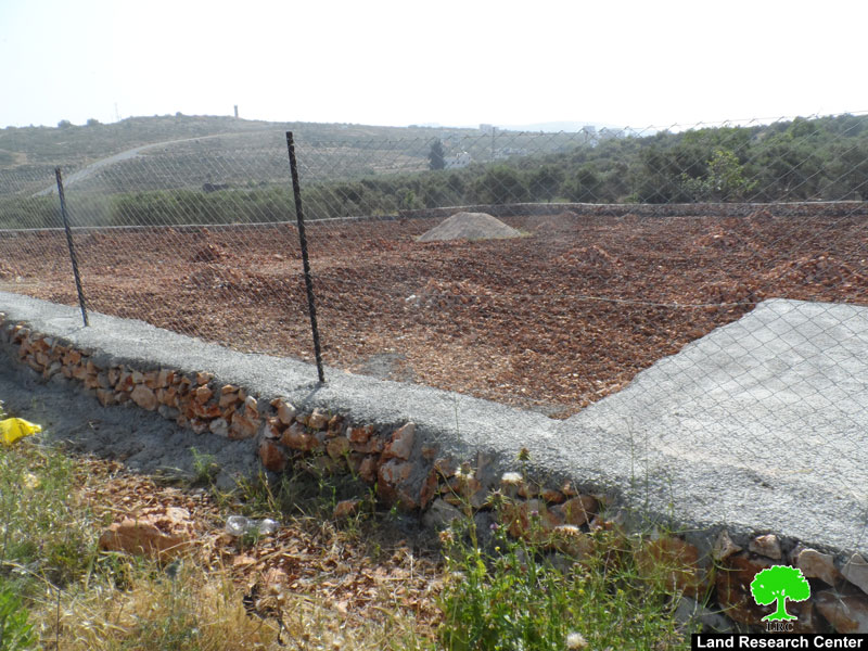
Photos 1+2 : The targeted plot

Affected farmer pointed out: “A year ago, I bought a plot and I recently started rehabilitating it in order to plant it with Olive trees , I also installed a siege around it, but I was shocked with a military notice claiming that the area is an antiquities site, while in fact nothing indicates that any antiquities were at the area.

The only thing I could do was to file an objection with the help of a legal aid institution, noting that I support a family of 6 , 2 of them are children.”

Noteworthy, The Occupation Authorities announced a large area of ‘Azzun as “State properties” , and another part as natural reserves. In other words, the occupation is imposing heavy restrictions on land use, as a result a large portion of the area’s residents had left.

About Azzun:[1]

Location: ‘Azzun town is located on the road between Nablus and Qalqilya known as bypass 55 , 23 km west Nablus , 9 km east Qalqilya , 22 Km south Tulkarm city , connected to Ramallah with a paved road that reaches to villages of Kufur Thulth , Masha , Deir Ballut , Birzeit , during the Jordanian Rule to Palestine a military road , consequently ‘Azzun is surrounded by many villages:

North: Sear , Jayous , Kufur Jamal , Kufur ‘Aboush , Kufur Zibad, Kufur Sour.

South: Kufur Thulth , Senirya, Masha, Bidya , Az-Zawiya.

West: An-Nabi Elyas , ‘Asla.

East: Kufur Laqif, Jinsafut , Hajja , Baqat Al-Hatab, Amatin , Fara’ata , Jit , Kufur Qadum , Sarra.

Area and People:

‘Azzun has  a total area of 24 thousand dunums, it reaches to the west to Habla and Qalqilya lands , and to the east to Kufur Laqif and Deir Istiya , and to the west , towards the green line to ‘Azzun forest known locally as (Tabsur),  but illegal Israeli Colonists however  call it Re’anana , only 9139 dunums remained out of 24 000 dunums , of which only 1209 are a built up area for the town.

According to 2017 census, ‘Azzun has a population of 11256 people , and it includes many hamlets and/or small villages like Asla , An-Nabi Elyas , ‘Azbet At-Tabeeb.

Colonization in ‘Azzun:

The occupation confiscated 903 dunums for the construction of settlements:

  • “Ma’ale Shemron” , established in 1980 , ate up 1903 dunums, with a built up area of 216 dunums , and populates 549 illegal settlers.
  • Ghanat Shamron establishe din 1985 , with a built up area 484 dunums.
  • Karnei Shamron , established in 1978 , with a total area of 7339 dunums , built up area 1351 dunums , and a population of 6270.


[1] GIS-LRC


Prepared by
The Land Research Center
LRC

Recommended For You

سلطات الاحتلال الإسرائيلي بصدد الاستيلاء على موقع قبر النبي صموئيل شمال غرب مدينة القدس

by arij
May 23, 2026
0
سلطات الاحتلال الإسرائيلي بصدد الاستيلاء على موقع قبر النبي صموئيل شمال غرب مدينة القدس

 نشرت سلطات الاحتلال الإسرائيلي في الثامن عشر من شهر أيار من العام 2026 اعلانا مفاده الاستيلاء على الأراضي الفلسطينية في قرية النبي صموئيل شمال غرب القدس المحتلة. وجاء...

Read moreDetails

إقامة منطقة عسكرية عسكرية داخل أراضي (أ) في جنين

by arij
May 19, 2026
0
إقامة منطقة عسكرية عسكرية داخل أراضي (أ) في جنين

   في السابع من شهر أيار من العام 2026، وزعت سلطات الاحتلال الإسرائيلي أمرا عسكريا جديدة على أهالي مدينة جنين يقضي بمصادرة 7.2 دونما من الأراضي الفلسطينية في...

Read moreDetails

“بمساحة اجمالية 177 دونما من أرضي البيرة وبيتين”, طريق استيطاني لخدمة البؤر الاستيطانية في محافظة رام الله

by arij
May 18, 2026
0
“بمساحة اجمالية 177 دونما من أرضي البيرة وبيتين”, طريق استيطاني لخدمة البؤر الاستيطانية في محافظة رام الله

في الحادي عشر من شهر أيار من العام 2026, نشرت دائرة أراضي إسرائيل اعلانا جديدا يقضي بمصادرة المزيد من الأراضي الفلسطينية في محافظة رام الله لأغراض استيطانية في...

Read moreDetails

“في خدمة مستوطنة ناحال حيلتس”, طريق استيطاني إسرائيلي جديد على أراضي بتير وبيت جالا في محافظة بيت لحم

by arij
May 18, 2026
0
“في خدمة مستوطنة ناحال حيلتس”, طريق استيطاني إسرائيلي جديد على أراضي بتير وبيت جالا في محافظة بيت لحم

تواصل سلطات الاحتلال الإسرائيلي إحكام سيطرتها على المزيد من الأراضي الفلسطينية في الضفة الغربية المحتلة، وهذه المرة من خلال استهداف أراضي محافظة بيت لحم. ففي السادس والعشرين من...

Read moreDetails

مناطق نفوذ المستوطنات ودورها في إعادة تشكيل الجغرافيا الفلسطينية

by arij
April 23, 2026
0
مناطق نفوذ المستوطنات ودورها في إعادة تشكيل الجغرافيا الفلسطينية

أصدرت سلطات الاحتلال الإسرائيلي في العاشر من شهر نيسان 2026 الكراسة رقم (273)، وهي وثيقة تضم مجموعة من المناشير والأوامر والتعيينات الإسرائيلية المتعلقة بالجوانب الأمنية والعسكرية والإدارية، إضافة...

Read moreDetails
Next Post
أمر عسكري بإغلاق طرق في مسافر يطا جنوب الخليل

Closure Imposed on Masafer Yatta Roads south Hebron

LATEST NEWS

سلطات الاحتلال الإسرائيلي بصدد الاستيلاء على موقع قبر النبي صموئيل شمال غرب مدينة القدس

سلطات الاحتلال الإسرائيلي بصدد الاستيلاء على موقع قبر النبي صموئيل شمال غرب مدينة القدس

by arij
May 23, 2026
0

........................................................

إقامة منطقة عسكرية عسكرية داخل أراضي (أ) في جنين

إقامة منطقة عسكرية عسكرية داخل أراضي (أ) في جنين

by arij
May 19, 2026
0

........................................................

الآثار كأداة للضم الزاحف: مشروع القانون الإسرائيلي لإعادة هندسة الجغرافيا والهوية في الضفة الغربية

الآثار كأداة للضم الزاحف: مشروع القانون الإسرائيلي لإعادة هندسة الجغرافيا والهوية في الضفة الغربية

by arij
May 23, 2026
0

........................................................

النكبة الفلسطينية في ذكراها الثامنة والسبعين: من التطهير العرقي إلى الإبادة وإعادة هندسة الجغرافيا الفلسطينية 

النكبة الفلسطينية في ذكراها الثامنة والسبعين: من التطهير العرقي إلى الإبادة وإعادة هندسة الجغرافيا الفلسطينية 

by arij
May 18, 2026
0

........................................................

flag_yellow_lowEU-PfP-Logo

This website and its content were initiated in 1993 by the Applied Research Institute – Jerusalem (ARIJ) and the Land Research Center (LRC) with the support from the European Union up until 2023. Since then, the Applied Research Institute – Jerusalem (ARIJ) has taken over the continued development and maintenance of the website. The views expressed remain solely those of ARIJ) and do not necessarily reflect those of the European Union.

© 2026 Copyright | ARIJ | All Rights reserved.

No Result
View All Result
  • Home
  • Settlements
    • New Israeli Settlements
    • Settlement Expansion
  • Israeli Violations
    • Agriculture
    • Confiscation
    • Demolition
    • Environment
    • Eviction of Palestinians
    • Settlers Attacks
  • Bypass Roads
  • Israeli Plans
  • Segregation
    • Checkpoints
    • Closure
    • Separation Plans
  • Military Orders
  • Reports
    • Daily Report
    • Monthly Report
    • Quarterly Report

© 2026 Copyright | ARIJ | All Rights reserved.