• About The Project
  • Palestine in Century
  • Selected Maps
  • Glossary
  • About ARIJ
  • About LRC
  • By Year
    • Case Studies By Year
    • Daily Report By Year
Friday, May 1, 2026
POICA
No Result
View All Result
  • Home
  • Settlements
    • New Israeli Settlements
    • Settlement Expansion
  • Israeli Violations
    • Agriculture
    • Confiscation
    • Demolition
    • Environment
    • Eviction of Palestinians
    • Settlers Attacks
  • Bypass Roads
  • Israeli Plans
  • Segregation
    • Checkpoints
    • Closure
    • Separation Plans
  • Military Orders
  • Reports
    • Daily Report
    • Monthly Report
    • Quarterly Report
No Result
View All Result
POICA
No Result
View All Result

Serving a demolition order targeting residential and agricultural structures in Dhera’ Awad / Tubas Governorate

February 20, 2019
in Military Orders
Serving a demolition order targeting residential and agricultural structures in Dhera’ Awad / Tubas Governorate


  • Violation: Serving a demolition order targeting residential and agricultural structures.
  • Location: Dhera’ Awwad – South East Tubas.
  • Date: December 25 – 2018.
  • Perpetrator: The occupation’s building and organizing commission.
  • Description:

The Israeli occupation troops raided Dhera’ Awwad area in December 25-2018 and served a demolition order to Adnan As-Salameen, the order number (050274) gives the affected Palestinian 7 days to object on the final demolition order.

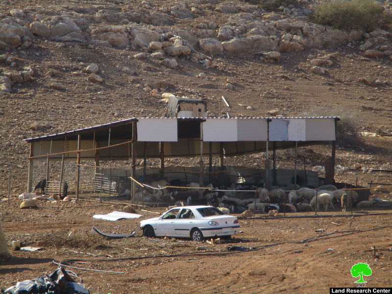
Field observation shows that the targeted structures are a barracks used for sheep husbandry (160 m2) , a residential room built of bricks and  zinc ceiling (60 m2  ) and a (9 m2 ) kitchen, the structure is a residence of a family of 15 , 11 of them are children.


Photos 1-2: The targeted structures.

Military order 050274

Affected farmer was subjected by Israeli demolition opertions 5 times in the recent years, he told LRC reporter: “agriculture and animal husbandry are my only source of income, I have been living in the area for more than 20 years, during that time I was a subject of Israeli violence. Lately, I consulted the Jerusalem center for human rights and legal aid, but the occupation, as usual uses deceiving ways and never gives a Palestinian a just trial”

About Dhra’ Awwad:

It should be marked that the area of Dhra’ Awwad is located 2km to the north of Al-Hamra military checkpoint and 30km to the south of Tubas. The area was notified of demolition until residents won a plea submitted to Israeli courts to halt demolitions. But this changed in the aftermath of the latest wave of rage in Jerusalem and the West Bank.

 The residents of Dhra’ Awwad come originally from the southern part of the occupied historic Palestine in 1948. Residents first fled to the area of  al-Samu’, south Hebron and then moved to the area of Dhra’ Awwad, looking for water and pastures.


Prepared by
 The Land Research Center
LRC

Recommended For You

مناطق نفوذ المستوطنات ودورها في إعادة تشكيل الجغرافيا الفلسطينية

by arij
April 23, 2026
0
مناطق نفوذ المستوطنات ودورها في إعادة تشكيل الجغرافيا الفلسطينية

أصدرت سلطات الاحتلال الإسرائيلي في العاشر من شهر نيسان 2026 الكراسة رقم (273)، وهي وثيقة تضم مجموعة من المناشير والأوامر والتعيينات الإسرائيلية المتعلقة بالجوانب الأمنية والعسكرية والإدارية، إضافة...

Read moreDetails

INFOGRAPHIC: Mapping Control – Israeli Militray Orders across the occupied West Bank – 2025

by arij
April 16, 2026
0

    Prepared by:   The Applied Research Institute – Jerusalem

Read moreDetails

سلطات الاحتلال الإسرائيلي تستهدف قرية الجيب بأمر عسكري جديد

by arij
March 17, 2026
0
سلطات الاحتلال الإسرائيلي تستهدف قرية الجيب بأمر عسكري جديد

نشر المسؤول عن الأملاك الحكومية وأملاك الغائبين في الإدارة المدنية الإسرائيلية في الحادي عشر من شهر اذار من العام 2026 اعلاننا مفاده نية ما يسمى " المسؤول عن...

Read moreDetails

سلطات الاحتلال الإسرائيلي تستخدم الأوامر العسكرية لتعمق المشروع الاستيطاني في الضفة الغربية المحتلة

by arij
February 26, 2026
0
سلطات الاحتلال الإسرائيلي تستخدم الأوامر العسكرية لتعمق المشروع الاستيطاني في الضفة الغربية المحتلة

تقديم منذ احتلال الضفة الغربية عام 1967، اعتمدت سلطات الاحتلال الإسرائيلي منهجية واسعة عبر استخدام الأوامر العسكرية كأداة "قانونية" لفرض الوقائع الجغرافية والديموغرافية على الأرض الفلسطينية. وأصبحت هذه...

Read moreDetails

بين مطرقة الأوامر العسكرية وسندان التقييد الجغرافي, أوامر عسكرية إسرائيلية جديدة تطال أكثر من 1000 دونم في طوباس

by arij
November 26, 2025
0
بين مطرقة الأوامر العسكرية وسندان التقييد الجغرافي, أوامر عسكرية إسرائيلية جديدة تطال أكثر من 1000 دونم في طوباس

في الحادي والعشرين من شهر تشرين الأول لعام 2025، تسلّم أهالي محافظة طوباس سلسلة من الأوامر العسكرية الإسرائيلية التي استهدفت مساحات واسعة من الأراضي الفلسطينية في المحافظة. وقد...

Read moreDetails
Next Post
Serving a demolition order targeting residential and agricultural structures in Dhera’ Awad / Tubas Governorate

الاحتلال الإسرائيلي  يخطر مواطناً بهدم منشآته السكنية والزراعية في منطقة ذراع عواد / محافظة طوباس

LATEST NEWS

مناطق نفوذ المستوطنات ودورها في إعادة تشكيل الجغرافيا الفلسطينية

مناطق نفوذ المستوطنات ودورها في إعادة تشكيل الجغرافيا الفلسطينية

by arij
April 23, 2026
0

........................................................

التمدد الاستيطاني الإسرائيلي في الضفة الغربية المحتلة وأثره في تقويض مقومات الدولة الفلسطينية

التمدد الاستيطاني الإسرائيلي في الضفة الغربية المحتلة وأثره في تقويض مقومات الدولة الفلسطينية

by arij
April 16, 2026
0

........................................................

INFOGRAPHIC: ISRAELI SETTLER VIOLENCE IN 2025

by arij
April 16, 2026
0

........................................................

العدالة المؤجلة ورأي بلا تنفيذ: من قرار المحكمة إلى واقع الضم

أدوات غير مباشرة للاستيطان الإسرائيلي في مناطق (أ) و(ب) لإعادة تشكيل الجغرافيا والسيطرة في الضفة الغربية   

by arij
April 16, 2026
0

........................................................

flag_yellow_lowEU-PfP-Logo

This website and its content were initiated in 1993 by the Applied Research Institute – Jerusalem (ARIJ) and the Land Research Center (LRC) with the support from the European Union up until 2023. Since then, the Applied Research Institute – Jerusalem (ARIJ) has taken over the continued development and maintenance of the website. The views expressed remain solely those of ARIJ) and do not necessarily reflect those of the European Union.

© 2026 Copyright | ARIJ | All Rights reserved.

No Result
View All Result
  • Home
  • Settlements
    • New Israeli Settlements
    • Settlement Expansion
  • Israeli Violations
    • Agriculture
    • Confiscation
    • Demolition
    • Environment
    • Eviction of Palestinians
    • Settlers Attacks
  • Bypass Roads
  • Israeli Plans
  • Segregation
    • Checkpoints
    • Closure
    • Separation Plans
  • Military Orders
  • Reports
    • Daily Report
    • Monthly Report
    • Quarterly Report

© 2026 Copyright | ARIJ | All Rights reserved.