• About The Project
  • Palestine in Century
  • Selected Maps
  • Glossary
  • About ARIJ
  • About LRC
  • By Year
    • Case Studies By Year
    • Daily Report By Year
Thursday, May 14, 2026
POICA
No Result
View All Result
  • Home
  • Settlements
    • New Israeli Settlements
    • Settlement Expansion
  • Israeli Violations
    • Agriculture
    • Confiscation
    • Demolition
    • Environment
    • Eviction of Palestinians
    • Settlers Attacks
  • Bypass Roads
  • Israeli Plans
  • Segregation
    • Checkpoints
    • Closure
    • Separation Plans
  • Military Orders
  • Reports
    • Daily Report
    • Monthly Report
    • Quarterly Report
No Result
View All Result
POICA
No Result
View All Result

Settlers uproot 80 olive trees in Ras Karkar Ramallah

November 12, 2018
in Settlers Attacks
Settlers uproot 80 olive trees in Ras Karkar Ramallah


  • Violation: uprooting trees.
  • Location: Ras Karkar town / North Ramallah.
  • Date: August 17, 2018.
  • Perpetrators: Settlers of “Nerya” outpost.
  • Victims: As-Samhan family.

Description:

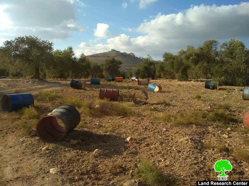
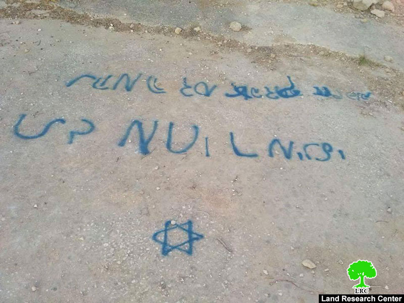
Friday afternoon, Number of settlers from “Nerya” illegal outpost sneaked to an agricultural area north-east Ras Karkar , about 3 km away from villagers homes but only 1.5 km away from the illegal outpost, and carried out ravaging, uprooted 80 trees and wrote radical provoking signs in Hebrew.

According to the ministry of agriculture report, they uprooted 80 trees (70 olive plants cultivated 3 years ago, 3 grapes plants and 7 millennial olive trees (60 years old) were partly destroyed by cutting parts of them), they also destroyed a cistern (with a 60 m3 capacity) through filling it with dirt and rocks, and wrote radical Hebrew signs on its door before they ran away from the location.


One of the affected villagers from As-Samhan family , Khaled Samhan (41) told LRC observer:

“Saturday morning, when my brothers and I headed to our land,  we were shocked when we found out that illegal settlers uprooted 70 trees and destroyed other 7 millennial olive trees by cutting parts of them, they also uprooted 3 grapes plants and felled a well with water and dirt, and wrote radical signs on the well’s door, we immediately called (The cooperation administration) then a number of Israeli police members came by, they wrote a report but did not do anything”

The area was always subjected by settlers as it is an agricultural area and contains more than 9 water springs.

Iyad Haddad an activist told LRC observer:

“Ras Karkar is a subjected area in the northern country side of Ramallah, it is about only 1.5 km away from3 Israeli illegal colonies (Talmon, Dolev and Neria) and about 3 Km from Ras Karkar built up area. In the recent years the area was subjected by Israeli violations like uprooting trees, destroying plants and water wells, and writing radical signs, the occupation’s police did not do anything to stop such assaults (the Israeli police is in charge in area C)

Ras Karkar[1]

15 kilometer north  west of Ramallah, Ras Karkar is surrounded by Deir ‘Ammar (north),  Kafr Ni’ma and Deir Ibziq  (south), Al Jania (east), Bani Harth (west).

Ras Karkar has a population of 1956 people according to statistics conducted by the Palestinian Central Bureau of Statistics in 2017. It has a total area of 5050, 330 of which are a built-up area of the village.

The Israeli occupation devoured more than 32  dunums of the lands of the village for Talmon C colony which was built in 1989. Moreover, bypass number ‘463 took over 295 dunums of the village lands.

According to Oslo Accords, 19% of Ras Karkar is under Area B (PA has full civil and security control) while most of the village lands (81%) is under Area C (Israel maintains full security and administrative control). Here are the area in dunums:

  • Area B (940) dunums
  • Area C (4110) dunums

[1] [i] Source: Geographic Information System- Monitoring Israeli Violations Team- Land Research Center

Prepared by
 The Land Research Center
LRC


Recommended For You

بين قصرة وترمسعيا: العنف الاستيطاني الاسرائيلي يضرب المجتمع الفلسطيني

by arij
May 6, 2026
0

في الثالث من شهر أيار من العام 2026، شهد مزارعون في عدة قرى في الضفة الغربية المحتلة على مشهد بات مألوفًا وقاسيا في آنٍ واحد: أشجار مثمرة مقطوعة...

Read moreDetails

INFOGRAPHIC: ISRAELI SETTLER VIOLENCE IN 2025

by arij
April 16, 2026
0

INFOGRAPHIC: ISRAELI SETTLER VIOLENCE IN 2025     Prepared by:   The Applied Research Institute – Jerusalem  

Read moreDetails

The West Bank: Between Settler Aggression and Occupation Support – 2025 Highlights

by arij
March 25, 2026
0
The West Bank: Between Settler Aggression and Occupation Support – 2025 Highlights

In the occupied West Bank (oWB), the violence committed by Israeli settlers is no longer a series of isolated, random attacks; it has effectively become a de facto...

Read moreDetails

From a Circle of Violence to a Circle of Impunity: The Structural Empowerment of Settlers

by arij
November 24, 2025
0

Beyond the “Violence Circle” In much of the global discourse, the Israeli settlers on the Palestinians frame the Israeli–Palestinian conflict as a “circle of violence”, a continuous sequence...

Read moreDetails

من دائرة العنف إلى دائرة الإفلات من العقاب: التمكين البنيوي للمستوطنين الإسرائيليين

by arij
November 24, 2025
0
“ما يزيد عن 25 ألف دونم من أراض الزيتون”, موسم الزيتون في فلسطين تحت رهن الأوامر العسكرية

ما وراء "دائرة العنف"              يشهد الصراع الفلسطيني الإسرائيلي منذ عقود متغيرات دراماتيكية، حيث يتجاوز العنف الذي تمارسه اسرائيل على الأرض الحدود التقليدية للمواجهات المسلحة ليصبح جزءا من هيكلية...

Read moreDetails
Next Post

ARIJ Daily Report –Sat, 11th 08 2018

LATEST NEWS

بين قصرة وترمسعيا: العنف الاستيطاني الاسرائيلي يضرب المجتمع الفلسطيني

by arij
May 6, 2026
0

........................................................

مناطق نفوذ المستوطنات ودورها في إعادة تشكيل الجغرافيا الفلسطينية

مناطق نفوذ المستوطنات ودورها في إعادة تشكيل الجغرافيا الفلسطينية

by arij
April 23, 2026
0

........................................................

التمدد الاستيطاني الإسرائيلي في الضفة الغربية المحتلة وأثره في تقويض مقومات الدولة الفلسطينية

التمدد الاستيطاني الإسرائيلي في الضفة الغربية المحتلة وأثره في تقويض مقومات الدولة الفلسطينية

by arij
April 16, 2026
0

........................................................

INFOGRAPHIC: ISRAELI SETTLER VIOLENCE IN 2025

by arij
April 16, 2026
0

........................................................

flag_yellow_lowEU-PfP-Logo

This website and its content were initiated in 1993 by the Applied Research Institute – Jerusalem (ARIJ) and the Land Research Center (LRC) with the support from the European Union up until 2023. Since then, the Applied Research Institute – Jerusalem (ARIJ) has taken over the continued development and maintenance of the website. The views expressed remain solely those of ARIJ) and do not necessarily reflect those of the European Union.

© 2026 Copyright | ARIJ | All Rights reserved.

No Result
View All Result
  • Home
  • Settlements
    • New Israeli Settlements
    • Settlement Expansion
  • Israeli Violations
    • Agriculture
    • Confiscation
    • Demolition
    • Environment
    • Eviction of Palestinians
    • Settlers Attacks
  • Bypass Roads
  • Israeli Plans
  • Segregation
    • Checkpoints
    • Closure
    • Separation Plans
  • Military Orders
  • Reports
    • Daily Report
    • Monthly Report
    • Quarterly Report

© 2026 Copyright | ARIJ | All Rights reserved.