• About The Project
  • Palestine in Century
  • Selected Maps
  • Glossary
  • About ARIJ
  • About LRC
  • By Year
    • Case Studies By Year
    • Daily Report By Year
Friday, June 5, 2026
POICA
No Result
View All Result
  • Home
  • Settlements
    • New Israeli Settlements
    • Settlement Expansion
  • Israeli Violations
    • Agriculture
    • Confiscation
    • Demolition
    • Environment
    • Eviction of Palestinians
    • Settlers Attacks
  • Bypass Roads
  • Israeli Plans
  • Segregation
    • Checkpoints
    • Closure
    • Separation Plans
  • Military Orders
  • Reports
    • Daily Report
    • Monthly Report
    • Quarterly Report
No Result
View All Result
POICA
No Result
View All Result

Stop-work orders on structures in the Ramallah village of Rammun

May 13, 2015
in Military Orders
Stop-work orders on structures in the Ramallah village of Rammun


Violation: stop-work orders on Bedouins’ residents

Location:  Rammun village-Ramallah

Date: May 13, 2015

Perpetrators: Planning and Construction Committee- Israel Civil Administration

Victims:  7 families (46 members including 21 children)

Details:

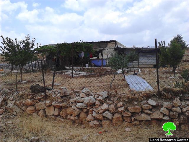
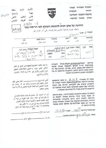
 A massive force from the Israeli occupation army accompanied by a staff from the Civil Administration on May 13, 2015 raided the area of Al-Shafaghoryih, east Rammun village in Ramallah governorate and delivered 7 Bedouin families stop-work orders on their structures under the claim of “unlicensed construction” within area classified “C” according to Oslo Accords.

According to the military order, the affected people were given a deadline until June 04, 2015 to complete all licensing procedures. This comes in time with the hearing session of the Planning and Construction Committee- Israel Civil Administration in the Israeli court of Beit El to consider the status of the notified structures.

The targeted Bedouin community is reported to be located 1km away from the master plan of Rammun village (from the east) and 2km to the west of Alon bypass road.

The chieftain of the Bedouin community Sheik Harun Al-Kalha told a researcher from Land Research Center the following:

“The 42 members of the community have been residing the area since 2008 as per to a leasing contract with Citizen Khlaif Mlaihat, taking into account the land is classified Tabo and has never been notified with either stop-work or demolition. Residents of this community used to live in the area of Al-Mu’arrajat before they got displaced in the aftermath of a collective demolition on their community”. The following table shows information about the damage resulted due to the latest order:

Affected citizen

Family

Minors

No.

No. and nature of structure

Photo

Order

Residence

Barns

Bathroom

Kitchen

Storehouse

Mohammad Ja’lih

8

0

250 sheep (partnership)

2 metal slabs barracks (60m2)+ one tent (90m2)

One barn(60m2)+

1

1

One storehouse (12m2)

1+2

307088

Salman Ja’lih

5

3

One metal slabs barrack (60m2)+

One barn(12m2)+

0

1

One storehouse (12m2)

3

Qusai Ja’lih

4

2

One metal slabs barrack (60m2)+

One tent (16m2)

0

0


4

Khalil Mlaihat

7

0

174 sheep (partnership)

2 metal slabs barracks (45m2)+ one tent (16m2)

two barn(60m2)+

1

1

One storehouse (9m2)

5+6

181518

Mohammad Mlaihat

6

4

One metal slabs barrack (60m2)+

One tent (45m2)

0

1

One storehouse (9m2)

7+8

Habis Mlaihat

8

6

One metal slabs barrack (45m2)+

One tent (45m2)

0

00

0

9+10

Ahmad Mlaihat

8

6

One metal slabs barrack (45m2)+


0


0

11+12


46

21

424

9 metal slabs barracks + 2 tents

4 metal slabs barracks + 3 tents

2

4

4


Source: Field observation- Department of Monitoring Israeli Violations- Land Research Center-2015


In reality, the issue is not all about unlicensed construction than it is on the occupation’s intention to take over more lands in the area of their control (Area C according to Oslo Accords). The Israeli occupation considers such lands as a colonial reserve, which will be hard to negotiate on in any future agreements with Palestinians.

 In a press conference, Israeli Minister of Economy Neftali Benet told journalist the following:  

“The Oslo era is almost over; a real epoch is getting introduced to Israel’s politics. It is time to vision an economic peace through increasing investments ,enhancing the lifestyle of Palestinians, applying the Israeli sovereignty on areas classified “C” according to Oslo Accords and giving residents of the those areas full Israeli citizenship”


Prepared by
 The Land Research Center
LRC
 

Recommended For You

سلطات الاحتلال الإسرائيلي بصدد الاستيلاء على موقع قبر النبي صموئيل شمال غرب مدينة القدس

by arij
May 23, 2026
0
سلطات الاحتلال الإسرائيلي بصدد الاستيلاء على موقع قبر النبي صموئيل شمال غرب مدينة القدس

 نشرت سلطات الاحتلال الإسرائيلي في الثامن عشر من شهر أيار من العام 2026 اعلانا مفاده الاستيلاء على الأراضي الفلسطينية في قرية النبي صموئيل شمال غرب القدس المحتلة. وجاء...

Read moreDetails

إقامة منطقة عسكرية عسكرية داخل أراضي (أ) في جنين

by arij
May 19, 2026
0
إقامة منطقة عسكرية عسكرية داخل أراضي (أ) في جنين

   في السابع من شهر أيار من العام 2026، وزعت سلطات الاحتلال الإسرائيلي أمرا عسكريا جديدة على أهالي مدينة جنين يقضي بمصادرة 7.2 دونما من الأراضي الفلسطينية في...

Read moreDetails

“بمساحة اجمالية 177 دونما من أرضي البيرة وبيتين”, طريق استيطاني لخدمة البؤر الاستيطانية في محافظة رام الله

by arij
May 18, 2026
0
“بمساحة اجمالية 177 دونما من أرضي البيرة وبيتين”, طريق استيطاني لخدمة البؤر الاستيطانية في محافظة رام الله

في الحادي عشر من شهر أيار من العام 2026, نشرت دائرة أراضي إسرائيل اعلانا جديدا يقضي بمصادرة المزيد من الأراضي الفلسطينية في محافظة رام الله لأغراض استيطانية في...

Read moreDetails

“في خدمة مستوطنة ناحال حيلتس”, طريق استيطاني إسرائيلي جديد على أراضي بتير وبيت جالا في محافظة بيت لحم

by arij
May 18, 2026
0
“في خدمة مستوطنة ناحال حيلتس”, طريق استيطاني إسرائيلي جديد على أراضي بتير وبيت جالا في محافظة بيت لحم

تواصل سلطات الاحتلال الإسرائيلي إحكام سيطرتها على المزيد من الأراضي الفلسطينية في الضفة الغربية المحتلة، وهذه المرة من خلال استهداف أراضي محافظة بيت لحم. ففي السادس والعشرين من...

Read moreDetails

مناطق نفوذ المستوطنات ودورها في إعادة تشكيل الجغرافيا الفلسطينية

by arij
April 23, 2026
0
مناطق نفوذ المستوطنات ودورها في إعادة تشكيل الجغرافيا الفلسطينية

أصدرت سلطات الاحتلال الإسرائيلي في العاشر من شهر نيسان 2026 الكراسة رقم (273)، وهي وثيقة تضم مجموعة من المناشير والأوامر والتعيينات الإسرائيلية المتعلقة بالجوانب الأمنية والعسكرية والإدارية، إضافة...

Read moreDetails
Next Post
“Additional opportunity to object a demolition” order on 9 residences in Jericho

“Additional opportunity to object a demolition” order on 9 residences in Jericho

LATEST NEWS

سلطات الاحتلال الإسرائيلي بصدد الاستيلاء على موقع قبر النبي صموئيل شمال غرب مدينة القدس

سلطات الاحتلال الإسرائيلي بصدد الاستيلاء على موقع قبر النبي صموئيل شمال غرب مدينة القدس

by arij
May 23, 2026
0

........................................................

إقامة منطقة عسكرية عسكرية داخل أراضي (أ) في جنين

إقامة منطقة عسكرية عسكرية داخل أراضي (أ) في جنين

by arij
May 19, 2026
0

........................................................

الآثار كأداة للضم الزاحف: مشروع القانون الإسرائيلي لإعادة هندسة الجغرافيا والهوية في الضفة الغربية

الآثار كأداة للضم الزاحف: مشروع القانون الإسرائيلي لإعادة هندسة الجغرافيا والهوية في الضفة الغربية

by arij
May 23, 2026
0

........................................................

النكبة الفلسطينية في ذكراها الثامنة والسبعين: من التطهير العرقي إلى الإبادة وإعادة هندسة الجغرافيا الفلسطينية 

النكبة الفلسطينية في ذكراها الثامنة والسبعين: من التطهير العرقي إلى الإبادة وإعادة هندسة الجغرافيا الفلسطينية 

by arij
May 18, 2026
0

........................................................

flag_yellow_lowEU-PfP-Logo

This website and its content were initiated in 1993 by the Applied Research Institute – Jerusalem (ARIJ) and the Land Research Center (LRC) with the support from the European Union up until 2023. Since then, the Applied Research Institute – Jerusalem (ARIJ) has taken over the continued development and maintenance of the website. The views expressed remain solely those of ARIJ) and do not necessarily reflect those of the European Union.

© 2026 Copyright | ARIJ | All Rights reserved.

No Result
View All Result
  • Home
  • Settlements
    • New Israeli Settlements
    • Settlement Expansion
  • Israeli Violations
    • Agriculture
    • Confiscation
    • Demolition
    • Environment
    • Eviction of Palestinians
    • Settlers Attacks
  • Bypass Roads
  • Israeli Plans
  • Segregation
    • Checkpoints
    • Closure
    • Separation Plans
  • Military Orders
  • Reports
    • Daily Report
    • Monthly Report
    • Quarterly Report

© 2026 Copyright | ARIJ | All Rights reserved.