• About The Project
  • Palestine in Century
  • Selected Maps
  • Glossary
  • About ARIJ
  • About LRC
  • By Year
    • Case Studies By Year
    • Daily Report By Year
Sunday, June 7, 2026
POICA
No Result
View All Result
  • Home
  • Settlements
    • New Israeli Settlements
    • Settlement Expansion
  • Israeli Violations
    • Agriculture
    • Confiscation
    • Demolition
    • Environment
    • Eviction of Palestinians
    • Settlers Attacks
  • Bypass Roads
  • Israeli Plans
  • Segregation
    • Checkpoints
    • Closure
    • Separation Plans
  • Military Orders
  • Reports
    • Daily Report
    • Monthly Report
    • Quarterly Report
No Result
View All Result
POICA
No Result
View All Result

Notifying a park and a tent with stop work in Wad Fukin

October 21, 2013
in Military Orders
Notifying a park and a tent with stop work in Wad Fukin


Violation: serving a stop work order on a park and a tent

Location: Wad Fukin/ Bethlehem governorate

Date: 21/10/2013

Perpetrators: Civil Administration – Supreme council- Inspection Sub-Committee

Victims: residents of the village

Details:

 On October 21st 2013, a massive force of the occupation army accompanied by the Civil Administration raided the area of Ein Midiak in the village of Wad Fukin and served the village council a stop work order on a park of 500m2 in area and a tent relative to it. This park is the only breather for the village residents.

The military order no. 160173 mentioned that the park and the tenet were unlicensed constructions and compelled the village council of immediate stop work.  October 13th 2013 was assigned as the session of the Inspection Sub-Committee to consider the status of the notified structures.

 The military order no. 160173


Photos1-3: a scene of the threatened park

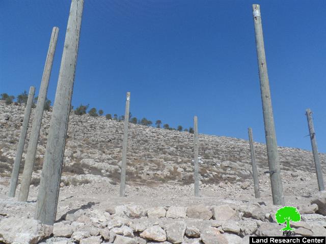
The military order no. 160174 served on the tent]

Photo4:  pillars for the under construction tent


It should be mentioned that the park was established in 2012 and funded by the government of the Netherlands for the sake of creating a recreational area for the residents. In terms of the tent, it was supposed to be expanded into another part of the park but the occupation came to destroy this dream. This proves the occupation brutality represented even in denying kids their right to play.

Citizen Rasha from the village council to the LRC researcher: "this very park is where all families gather and meet where kids play and enjoy their time. It is considered the only recreational area in the village. The park is located in Ein Midiak, which is surrounded by green mountains of captivating scenery. The occupation invested all effort to harass us by serving the stop work order on the park and by colonial expansion on a wider spectrum".

A resident of town Jamil Assaf to the LRC said that: "if the park gets closed, the only breather for the people in the area will be shut down. Kids will be denied the right to play and families will be deprived from a recreational place". 

The reason behind serving an order on the park is the interests of Betar Illit colonists  in the area. Every now and then, colonists break into the park and sit there as if it was theirs. This bans Palestinians from being in the area. Not only that, colonists used to throw stones on people at the park to harass them and push them to leave so they can hang out in there.

About Wad Fukin:

It is located 15 kilometer west of Bethlehem and is surrounded by the borders of 1967 (north and west), Nahhalin and Husan (east), and Jab'a (south). Wad Fukin has a population of 1168 according to statistics conducted in 2007. It has a total area of 3817 dunums, 161 of which are built-up area.

The Israeli occupation confiscated 299 dunums of Wadi Fukin lands for the sake of two colonies. The first is Har Hadasa which was built in 1978 and devoured 4 dunums while the other is Betar Illit which was built in 1985 and confiscated 295 dunums.

The Apartheid Wall confiscated 402 dunums and isolated 980 dunums in a way that denies people access to their lands. The length of the constructed Wall on Fukin lands is 4,029 meters.

According to Oslo Accords, 7% of Wad Fukin is under Area B (PA is in charge of civil matters with Israel responsible for security) while most of the village lands (93%) is under Area C (Israel maintains full security and administrative control). Here are the area in dunums:

  • Area B (275) dunums
  • Area C (3500) dunums


Prepared by
The Land Research Center
LRC


Recommended For You

سلطات الاحتلال الإسرائيلي بصدد الاستيلاء على موقع قبر النبي صموئيل شمال غرب مدينة القدس

by arij
May 23, 2026
0
سلطات الاحتلال الإسرائيلي بصدد الاستيلاء على موقع قبر النبي صموئيل شمال غرب مدينة القدس

 نشرت سلطات الاحتلال الإسرائيلي في الثامن عشر من شهر أيار من العام 2026 اعلانا مفاده الاستيلاء على الأراضي الفلسطينية في قرية النبي صموئيل شمال غرب القدس المحتلة. وجاء...

Read moreDetails

إقامة منطقة عسكرية عسكرية داخل أراضي (أ) في جنين

by arij
May 19, 2026
0
إقامة منطقة عسكرية عسكرية داخل أراضي (أ) في جنين

   في السابع من شهر أيار من العام 2026، وزعت سلطات الاحتلال الإسرائيلي أمرا عسكريا جديدة على أهالي مدينة جنين يقضي بمصادرة 7.2 دونما من الأراضي الفلسطينية في...

Read moreDetails

“بمساحة اجمالية 177 دونما من أرضي البيرة وبيتين”, طريق استيطاني لخدمة البؤر الاستيطانية في محافظة رام الله

by arij
May 18, 2026
0
“بمساحة اجمالية 177 دونما من أرضي البيرة وبيتين”, طريق استيطاني لخدمة البؤر الاستيطانية في محافظة رام الله

في الحادي عشر من شهر أيار من العام 2026, نشرت دائرة أراضي إسرائيل اعلانا جديدا يقضي بمصادرة المزيد من الأراضي الفلسطينية في محافظة رام الله لأغراض استيطانية في...

Read moreDetails

“في خدمة مستوطنة ناحال حيلتس”, طريق استيطاني إسرائيلي جديد على أراضي بتير وبيت جالا في محافظة بيت لحم

by arij
May 18, 2026
0
“في خدمة مستوطنة ناحال حيلتس”, طريق استيطاني إسرائيلي جديد على أراضي بتير وبيت جالا في محافظة بيت لحم

تواصل سلطات الاحتلال الإسرائيلي إحكام سيطرتها على المزيد من الأراضي الفلسطينية في الضفة الغربية المحتلة، وهذه المرة من خلال استهداف أراضي محافظة بيت لحم. ففي السادس والعشرين من...

Read moreDetails

مناطق نفوذ المستوطنات ودورها في إعادة تشكيل الجغرافيا الفلسطينية

by arij
April 23, 2026
0
مناطق نفوذ المستوطنات ودورها في إعادة تشكيل الجغرافيا الفلسطينية

أصدرت سلطات الاحتلال الإسرائيلي في العاشر من شهر نيسان 2026 الكراسة رقم (273)، وهي وثيقة تضم مجموعة من المناشير والأوامر والتعيينات الإسرائيلية المتعلقة بالجوانب الأمنية والعسكرية والإدارية، إضافة...

Read moreDetails
Next Post

ARIJ Daily Report - Tue, 22/10/2013

LATEST NEWS

سلطات الاحتلال الإسرائيلي بصدد الاستيلاء على موقع قبر النبي صموئيل شمال غرب مدينة القدس

سلطات الاحتلال الإسرائيلي بصدد الاستيلاء على موقع قبر النبي صموئيل شمال غرب مدينة القدس

by arij
May 23, 2026
0

........................................................

إقامة منطقة عسكرية عسكرية داخل أراضي (أ) في جنين

إقامة منطقة عسكرية عسكرية داخل أراضي (أ) في جنين

by arij
May 19, 2026
0

........................................................

الآثار كأداة للضم الزاحف: مشروع القانون الإسرائيلي لإعادة هندسة الجغرافيا والهوية في الضفة الغربية

الآثار كأداة للضم الزاحف: مشروع القانون الإسرائيلي لإعادة هندسة الجغرافيا والهوية في الضفة الغربية

by arij
May 23, 2026
0

........................................................

النكبة الفلسطينية في ذكراها الثامنة والسبعين: من التطهير العرقي إلى الإبادة وإعادة هندسة الجغرافيا الفلسطينية 

النكبة الفلسطينية في ذكراها الثامنة والسبعين: من التطهير العرقي إلى الإبادة وإعادة هندسة الجغرافيا الفلسطينية 

by arij
May 18, 2026
0

........................................................

flag_yellow_lowEU-PfP-Logo

This website and its content were initiated in 1993 by the Applied Research Institute – Jerusalem (ARIJ) and the Land Research Center (LRC) with the support from the European Union up until 2023. Since then, the Applied Research Institute – Jerusalem (ARIJ) has taken over the continued development and maintenance of the website. The views expressed remain solely those of ARIJ) and do not necessarily reflect those of the European Union.

© 2026 Copyright | ARIJ | All Rights reserved.

No Result
View All Result
  • Home
  • Settlements
    • New Israeli Settlements
    • Settlement Expansion
  • Israeli Violations
    • Agriculture
    • Confiscation
    • Demolition
    • Environment
    • Eviction of Palestinians
    • Settlers Attacks
  • Bypass Roads
  • Israeli Plans
  • Segregation
    • Checkpoints
    • Closure
    • Separation Plans
  • Military Orders
  • Reports
    • Daily Report
    • Monthly Report
    • Quarterly Report

© 2026 Copyright | ARIJ | All Rights reserved.