• About The Project
  • Palestine in Century
  • Selected Maps
  • Glossary
  • About ARIJ
  • About LRC
  • By Year
    • Case Studies By Year
    • Daily Report By Year
Thursday, June 25, 2026
POICA
No Result
View All Result
  • Home
  • Settlements
    • New Israeli Settlements
    • Settlement Expansion
  • Israeli Violations
    • Agriculture
    • Confiscation
    • Demolition
    • Environment
    • Eviction of Palestinians
    • Settlers Attacks
  • Bypass Roads
  • Israeli Plans
  • Segregation
    • Checkpoints
    • Closure
    • Separation Plans
  • Military Orders
  • Reports
    • Daily Report
    • Monthly Report
    • Quarterly Report
No Result
View All Result
POICA
No Result
View All Result

New military road under construction in Kafr Qadum village

August 20, 2007
in Military Orders
New military road under construction in Kafr Qadum village

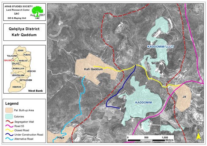
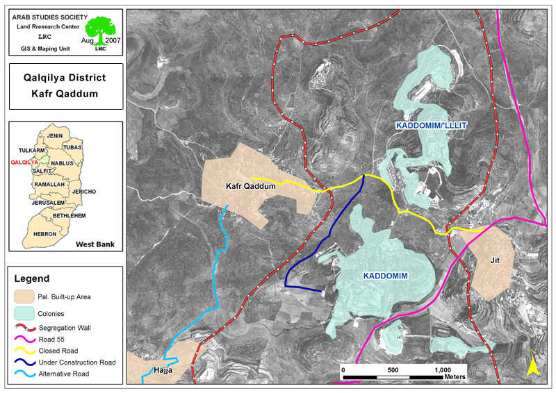
At the beginning of this month Israeli bulldozers started to open a new Military road at the length of 1904 m and width of 5 meters connecting between what so-called ' Israeli civil administration offices' in the north western side of the  colony of Kaddomim and the local road that links between the village of Kafr Qadum and the main Nablus – Qalqiliay road number 55.


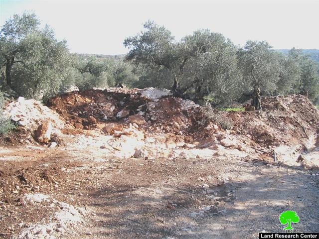
The aforementioned local road has been closed for Palestinian use ever since the beginning of the current uprising in the year 2000 under the pretext of being close to the borders of Kaddomim Elite (kaddomim north colony).  In reality, this road was closed because it passes between the colony of Kaddomim and Kaddomim north (yellow color in the attached map), an area considered vital for the geographical continuity of  the two colonies, hence,  targeted for confiscation. See Map 1 & Photo 1


 (Photo 1: closed local road passing by Kaddomim Elite colony)


The under construction military road bypasses the colony from the west before it meets the local closed Kafr Qadum road that leads to road number 55.


Last March, the Israeli occupation army issued a military order carrying the number of T/15/07 stating the confiscation of 9 dunums and 520 square meters for the construction of the above mentioned road for ' security matters'.


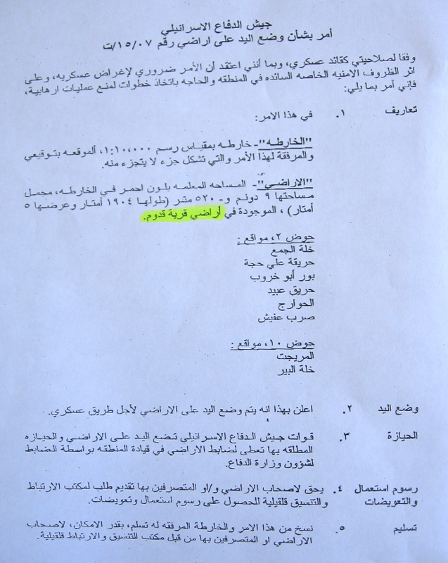
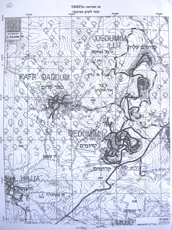
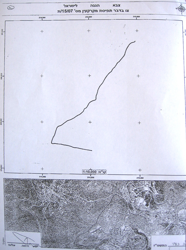
(Photos 2, 3 & 4 : a copy of the military order and attached maps)


Impact of the  road on Kafr Qadum village

The following are some of the impacts of the road on the village:

1.     Expropriating more Palestinian land , uprooting more than 900 fruitful olive trees and separating about 1600 dunums of most fertile land located between the under construction road and the colony of Kaddomim. This land is the main source of living for more than 50 families who will be added to the  64% unemployment record in the village  because of the ongoing closure and repressive measures.

1.     Some Palestinian houses are situated only 170 meters from the under construction road which will put them under the threat of demolition for ' security reasons'  as always claimed..

2.     The construction of the road will end the hope in any possible future re-opening of the closed Kafr Qadum road as part of it will become a military road  only used by the army to reach the Nablus- Qalqiliya main road number 55. This means a total blockage of the village from the east and a geographical continuity between Kaddomim and its northern colonial expansion of Kaddomim Elite (see the attached map). The closure of this road has increased the suffering of the village citizens as they are obliged to use a longer, more costly and underdeveloped alternative road through Hajja village down south before reaching road 55 to Nablus.


Introduction to Kafr Qadum

The village of Kafr Qadum is located Qalqiliya governorate, 12 km to the west of Nablus city and 25 km to the east of Qalqiliya city. The village's total land area is 17161 dunums (one dunum equals 1000 M2) of which only 398 dunums are built up area. 2500 dunums of the village land area are grazing zones, 5000 dunums have been taken for the construction of Kaddomim colony and its future colonial expansion and the remaining areas are agricultural fields of which 85 % are covered with olive trees. Out of 640 families there are 280 families who totally depend on foreign aid for survival due to the ongoing Israeli military closure and ensuing economic hardships.


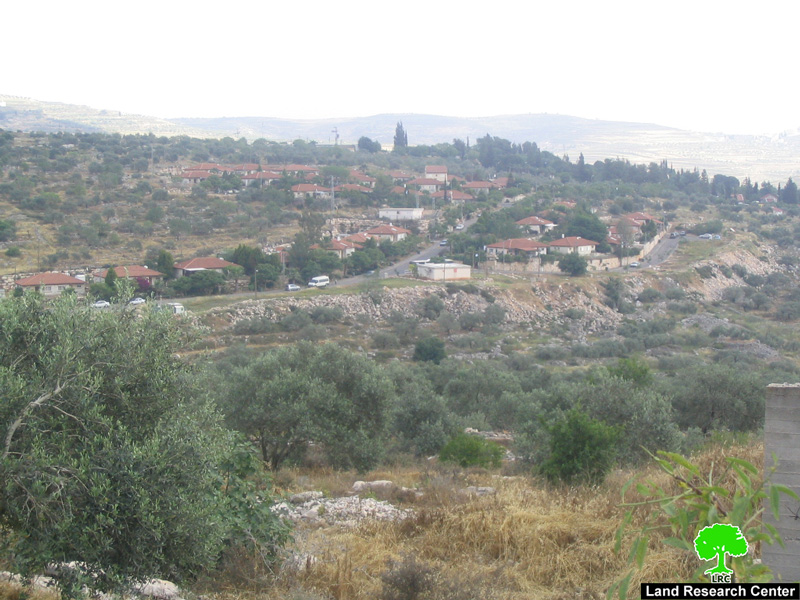
(Photo 5: a general view of Kafr Qaddum village)


Kaddomim colony

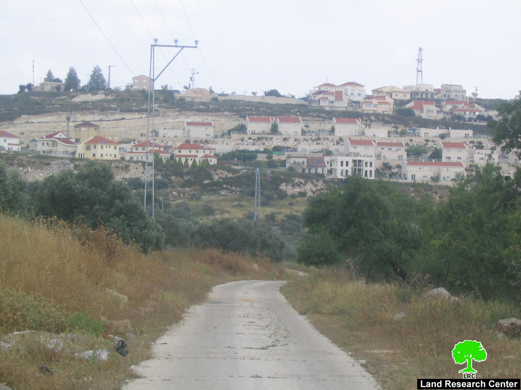
The colony of Kaddomim was established in 1975 and then extended north and south to become one of the biggest colonies in the occupied West Bank. During this on going expansion process, the colony of Kaddomim Illit (Kaddomim North) as well as the colony of Jabel Mohammed (Kaddomim South) were  also founded at the expense of  the lands of the Palestinian village of Kafr Qaddum. At the end of 2005, the total number of settlers living in these three colonies reached 3087, while their built up are was 1003 dunums and municipal boundaries was 2039 dunums (Source: Foundation for Middle East Peace).


(Photo 6 : The colony of Kaddomim built over Kafr Kaddum land in 1975)


Related case study

  • Land confiscated for military road in Kafr Qaddum village, Qalqiliya governorate, June, 2007.


Prepared by
The Land Research Center
LRC


Recommended For You

الاحتلال الاسرائيلي يوسع سيطرته على أراضي جبل الفرديس بمصادرة 317 دونم اخرى

by arij
June 15, 2026
0
الاحتلال الاسرائيلي يوسع سيطرته على أراضي جبل الفرديس بمصادرة 317 دونم اخرى

  في الخامس والعشرين من شهر ايار من العام 2026 نشرط سلطات الاحتلال الاسرائيلي امرا عسكريا جديدا يحمل اسم "أمر بشأن قانون الأراضي استملاك للمصلحة العامة) (يهودا والسامرة)...

Read moreDetails

بواقع 19 دونما – سلسلة من الأوامر العسكري الإسرائيلي تستهدف أراضي محافظة بيت لحم بذريعة الأغراض العسكرية

by arij
June 13, 2026
0
بواقع 19 دونما – سلسلة من الأوامر العسكري الإسرائيلي تستهدف أراضي محافظة بيت لحم بذريعة الأغراض العسكرية

سلمت سلطات الاحتلال الإسرائيلي أهالي محافظة بيت لحم سلسلة من الأوامر العسكرية لمصادرة مساحات شاسعة من الأراضي الفلسطينية في المحافظة بذريعة أغراض عسكرية. واستهدفت الأوامر العسكرية الجديدة عددا...

Read moreDetails

بمساحة اجمالية بلغت 208 دونما – سلطات الاحتلال الإسرائيلي تصادر الاراضي في محافظة طوباس لصالح معسكر اسرائيلي

by arij
June 13, 2026
0
بمساحة اجمالية بلغت 208 دونما – سلطات الاحتلال الإسرائيلي تصادر الاراضي في محافظة طوباس لصالح معسكر اسرائيلي

سلّمت سلطات الاحتلال الإسرائيلي، في السابع من حزيران 2026، أهالي مدينة طوباس شمال الضفة الغربية المحتلة أمراً عسكرياً جديداً بعنوان: "أمر بشأن وضع اليد على أراضٍ رقم 79/26/ت...

Read moreDetails

الاحتلال يرسّخ بؤرة “يتسيف” الاستيطانية عبر تخصيص 92 دونماً من أراضي بيت ساحور

by arij
June 9, 2026
0
الاحتلال يرسّخ بؤرة “يتسيف” الاستيطانية عبر تخصيص 92 دونماً من أراضي بيت ساحور

أصدر جيش الاحتلال الإسرائيلي في الخامس من شهر اذار من العام 2026 إعلاناً عسكرياً جديداً موقع من قبل ما يُسمّى بـ “قائد قوات جيش الدفاع الإسرائيلي في منطقة...

Read moreDetails

كراسة أوامر إسرائيلية جديدة تمهد لمصادرة أكثر من 20 ألف دونم في الضفة الغربية المحتلة

by arij
June 9, 2026
0
كراسة أوامر إسرائيلية جديدة تمهد لمصادرة أكثر من 20 ألف دونم في الضفة الغربية المحتلة

في الخامس من شهر اذار من العام 2026، أصدرت سلطات الاحتلال الإسرائيلي كراسة جديدة من الأوامر العسكرية التي تهدف إلى توسيع نطاق النشاطات الاستيطانية على الأراضي الفلسطينية، وذلك...

Read moreDetails
Next Post
Closing of all the local agricultural roads in Deir Al Ghusun town

Closing of all the local agricultural roads in Deir Al Ghusun town

LATEST NEWS

الاحتلال الاسرائيلي يوسع سيطرته على أراضي جبل الفرديس بمصادرة 317 دونم اخرى

الاحتلال الاسرائيلي يوسع سيطرته على أراضي جبل الفرديس بمصادرة 317 دونم اخرى

by arij
June 15, 2026
0

........................................................

بواقع 19 دونما – سلسلة من الأوامر العسكري الإسرائيلي تستهدف أراضي محافظة بيت لحم بذريعة الأغراض العسكرية

بواقع 19 دونما – سلسلة من الأوامر العسكري الإسرائيلي تستهدف أراضي محافظة بيت لحم بذريعة الأغراض العسكرية

by arij
June 13, 2026
0

........................................................

بمساحة اجمالية بلغت 208 دونما – سلطات الاحتلال الإسرائيلي تصادر الاراضي في محافظة طوباس لصالح معسكر اسرائيلي

بمساحة اجمالية بلغت 208 دونما – سلطات الاحتلال الإسرائيلي تصادر الاراضي في محافظة طوباس لصالح معسكر اسرائيلي

by arij
June 13, 2026
0

........................................................

الاحتلال يرسّخ بؤرة “يتسيف” الاستيطانية عبر تخصيص 92 دونماً من أراضي بيت ساحور

الاحتلال يرسّخ بؤرة “يتسيف” الاستيطانية عبر تخصيص 92 دونماً من أراضي بيت ساحور

by arij
June 9, 2026
0

........................................................

flag_yellow_lowEU-PfP-Logo

This website and its content were initiated in 1993 by the Applied Research Institute – Jerusalem (ARIJ) and the Land Research Center (LRC) with the support from the European Union up until 2023. Since then, the Applied Research Institute – Jerusalem (ARIJ) has taken over the continued development and maintenance of the website. The views expressed remain solely those of ARIJ) and do not necessarily reflect those of the European Union.

© 2026 Copyright | ARIJ | All Rights reserved.

No Result
View All Result
  • Home
  • Settlements
    • New Israeli Settlements
    • Settlement Expansion
  • Israeli Violations
    • Agriculture
    • Confiscation
    • Demolition
    • Environment
    • Eviction of Palestinians
    • Settlers Attacks
  • Bypass Roads
  • Israeli Plans
  • Segregation
    • Checkpoints
    • Closure
    • Separation Plans
  • Military Orders
  • Reports
    • Daily Report
    • Monthly Report
    • Quarterly Report

© 2026 Copyright | ARIJ | All Rights reserved.