On April 21, 2007, Um Salamouna village south of Bethlehem city received new Israeli military orders to demolish six Palestinian houses in the village under the pretext of lacking building permits. See the Table below:
Table 1: Owners of houses and Military Orders' Numbers
|
Owner's Name |
Military Order No. |
|
Mohammad Mahmoud Hayyan |
|
|
Mohammad Talab Taqatqa |
|
|
Khaled 'lyan |
|
|
Akram Isma'eel Abu Rahma |
|
|
Sami Ibrahim Taqatqa |
|
|
NA |
141212 |
Source: Um Salamuna Village Council – 2007
It is worth mentioning that the six threatened houses were built on a total area of 720 square meters, with a total cost exceeds 500,000 NIS ($125,000). According to the military orders, the owners of the houses may file their objections at the Israeli Civil Administration in Beit El by May 10, 2007, even though its rejections are a certainty based on thousands of similar cases.
Um Salamouna Village
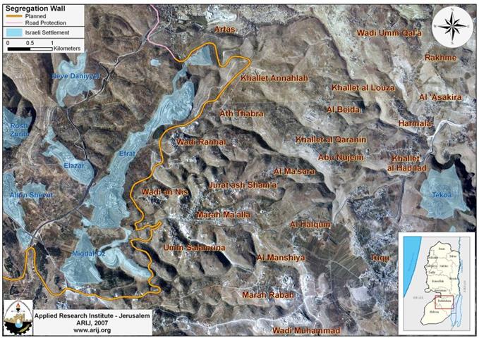
Um Salamouna, a small Palestinian village located south of Bethlehem Government, housed a population of 807 residents (PCBS 2006). The Israeli Apartheid Segregation Wall surrounded Um Salamouna village at its western side, Al Halqum village lays to the east, Marah M'alla village to its north and the village of Marah Rabah at its south side.
The Israeli Segregation Wall Southwest Bethlehem Governorate
The Israeli Segregation Wall section in southwest Bethlehem starts at the governorate's northwestern parts at the city of Beit Jala (from bypass road #60, the tunnel section), and runs along road # 60 west of Artas village where it runs eastward to encompasses all of Efrat settlement (established in 1979, pop. 7300 Israeli settlers). It is worth mentioning that the constructions in this section of the Segregation Wall started in December 2005. See map 1

Map of the Wall in Southwest Bethlehem
This section of the Segregation Wall stretches for a length of 16.3 kilometers, comprising about 31% of the total Wall length in Bethlehem Governorate. It is routed to confine the entire western rural areas (53,261 Dunums, nearly 9% of the Bethlehem governorate's area), which include villages of Al Walajeh, Battir, Husan, Nahalin and Wadi Fukin, Khallet 'Afaneh, Khallet Al Balluta and Khallet Beit Sakaria in one Big Ghetto; population exceed 20,000) will be segregated West of the Wall from Bethlehem Governorates lands. The segregated area includes the Palestinian villages segregated in addition to 12 Israeli settlements within what the Israeli call, the Gush Etzion settlements bloc, of which 10 settlements in Bethlehem and 2 in Hebron).
Um Salamouna Planned Terminal
On September 5, 2006, Palestinian residents from Bethlehem and Hebron Governorates received the military order # (69/06/T), in which 152 dunums of their own lands will be confiscated to construct a new terminal southwest of Bethlehem Governorate (Umm Salamouna Planned Terminal), and to resume the construction of the Israeli Segregation Wall in that same area.), in which of their own lands will be confiscated to construct a new terminal southwest of Bethlehem Governorate (Umm Salamouna Planned Terminal), and to resume the construction of the Israeli Segregation Wall in that same area.
The Israeli plan for Um Salamouna terminal comes to serve the Israeli policy to tighten the grip on the Palestinians and their movement and access to their agricultural lands, but more than that, it will serve as a commercial terminal leading to alternative route for the Palestinian trucks to use in order to avoid using the settlers bypass road # 60. See Map 2

Map of Um Salamouna Planned Terminal
Finally, the most common Israeli pretext to demolish the Palestinian houses in area 'C' (according to Oslo Agreement fall under Israeli control) is the lack of building permits as the Israeli civil administration imposes incapacitating conditions on issuing building licenses to Palestinians and most of the applications submitted for building licenses are often rejected, leaving the Palestinians with no other option but to build without permits, despite the fact that the Israeli civil administration; being an occupation power is not entitled to carry out any demolishing unless rendered as a security threat.
Under the Fourth Geneva Convention, Israel, the occupying power, are prohibited from destroying the Palestinian properties.
-
Article 53 of the convention provides that: Any destruction by the Occupying Power of real or personal property belonging individually or collectively to private persons, or to the State, or to other public authorities, or to social or cooperative organizations, is prohibited, except where such destruction is rendered absolutely necessary by military operations.
-
Article 147 of the same convention indicated that: Extensive destruction and appropriation of property not justified by military necessity and carried out unlawfully and wantonly. is a grave breach of the Convention.
-
Art. 23 of the Hague Convention of 1907 also provide: In addition to the prohibitions provided by special Conventions, it is especially forbidden to destroy or seize the enemy's property, unless such destruction or seizure be imperatively demanded by the necessities of war;
Israel and since the first day of its occupation of the Palestinian Territory, relentlessly and persistently violated all the International law rules and agreements, practicing aggressively against the Palestinians, exploiting the international silence and that no deterrent measure against their doings have been taken, something that encouraged them to continue to adopt escalating measures against the owners of the land, as in the case of the six aforementioned families whom houses will be demolished sooner than later.
Prepared by
The Applied Research Institute – Jerusalem
ARIJ