An Israeli Company announced plans to develop 165 dunums of lands belongs to Haris village residents. The land of issue were declared 'confiscated' by the Israeli Occupation Forces some time ago (18+ months) through a military order that was randomly dispersed in the fields for the village residents to find, the order stated that the confiscation is for the construction of the Israeli Segregation Wall.
Haris village is located to the northwest of Salfit city (northwest of the West Bank). It sets on a total area of 8370 dunums, out of which, 242 dunums classified as the built-up area where population exceeds 3000 residents according to the Palestinian central Bureau of Statistics– 2006. The village is bordered by a strip of Israeli settlements from the west and the south (Barqan, Barqan industrial zone, Revava and Kiryat Netafim); the village of Deir Istiya from the north and the village of Kifl Haris from the east.
The Israeli Settlement impact on in Haris Village
The Village of Haris is one of many Palestinian cities and villages that has fallen a victim to the Israeli settlement program which commenced following Israel's occupation of the Wet Bank and the Gaza Strip in 1967. Today Five Israel settlements with an area of 4779 dunums surround the village of Haris, out of which, 2980 Dunums (36%) belong to Haris village residents. See table 1: Israeli settlements established on lands of Haris Village.
Table 1: Israel settlements established on lands of Haris village
|
No. |
NAME |
Establishment Date |
Area in Dunums |
POP_2006 |
|
Barqan |
1981 |
649 |
1319 |
|
|
Barqan industrial Zone |
1991 |
399 |
Industrial Settlement |
|
|
Revava |
1981 |
1417 |
868 |
|
|
Kiryat Netafim |
1982 |
386 |
444 |
|
|
West (Arial West Park Industrial) |
0 |
1928 |
Industrial Settlement |
|
|
|
Total |
|
4779 |
2631 |
Source: ARIJ GIS Database 2006
The Israeli Segregation Wall threatens the existence of Haris village
Today the village of Haris is facing a greater threat than that to lose considerable portion of its lands, it is threaten of extinction because of the Israeli Segregation Wall. An Analysis conducted by the GIS unit at the Applied Research Institute – Jerusalem (ARIJ) of the Israeli revised Segregation Wall route of April 30, 2006 concluded that the village of Haris will lose more than 90 percents of its lands behind the Israeli Segregation Wall which will run for 2.1 km on lands of the village, starting from its southern side where it moves toward the western side of the village; see Table 2, land use land cover of Haris village and the lands slated for isolation by the Israeli Segregation Wall.
Table 2: Land Use/ Land Cover of Haris village Lands
|
Land Use/ Land Cover of Haris village |
Land Area classification in Haris village |
Of which land isolated behind the Segregation Wall |
% of total village area. |
|
Agricultural lands (Arable land & permanent Crops ) |
1729 |
1416 |
17% |
|
Forests & Open spaces with little or no vegetation) |
3422 |
3415 |
40.8% |
|
Jewish settlement |
2977 |
2977 |
35.6% |
|
Palestinian Built-up Area |
242 |
31 |
0.4% |
|
Total Area |
8370 |
7839 |
93.8% |
Source: ARIJ GIS Database 2006
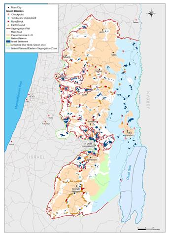
Table 2 above clearly illustrates how the Israeli Segregation Wall is routed to encompass the five Israeli settlements around Haris village and more than that it takes in the greater part of the village's open spaces and agricultural lands; all which evidently confirm that Israel’s intention aim to include the settlements and as much uninhabited lands from the West Bank before they carryout the yet another unilateral so-called disengagement (redeployment) from selected areas in the West Bank ; much similar to that carried out in Gaza in 2005. See Map 1
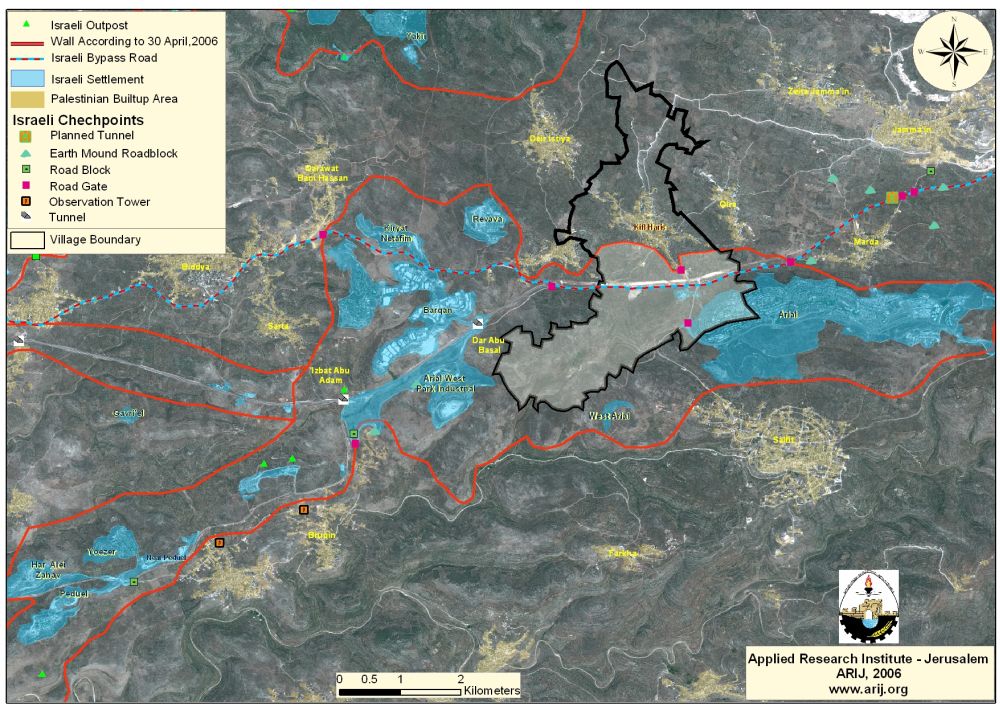
The Israeli Segregation Wall around Ariel Settlement Bloc
The Segregation Wall in Haris village is a part-section of the Segregation Wall set to enfold Ariel settlements Bloc. According to the Israeli Army’s updated map of the Segregation Wall in the West Bank, published on April 30, 2006, the Segregation Wall around Ariel settlements bloc is set to divide the settlements bloc into two segments, the Ariel finger and the Kedumim finger. The Ariel Finger will run a length of 81.5 Km to enclose 57.5 Km² and will encompass 14 Israeli settlements with a population exceeding 24000 Israeli settlers, including three industrial Zones.
As for Kedumim Finger, it will run a length of 45.5 km² to enclose 51.5 Km² and to encompass a total of 12 Israeli settlements housing more than 19000 Israeli Settlers.
According to the new arrangement with regard to the Segregation Wall previously set to circulate Ariel settlements bloc and what came afterward, the length of the Segregation Wall has increased from 120 km to 133 km in the new map of April 30, 2006; causing the Palestinians to lose more lands; and even worse place a number of Palestinian villages in an isolated enclaves, totally segregated from the surrounding Palestinian villages and their traditional way of life.
To Conclude
Israel's decision to construct the Segregation Wall has violated all International Laws and Human rights Conventions for its malicious and devastative consequences to Palestinians’ way of life and their lands and natural resources as it deprive them their conventional rights assigned to them by the laws and conventions especially the right to freedom of movement which is protected by Article 12 of the International Covenant on Civil and Political Rights (ICCPR), which states: 'Everyone lawfully within the territory of a State shall, within that territory, have the right to liberty of movement and freedom to choose his residence.'correspondingly stated in Article 3 of the Fourth Geneva Convention of 1949 also strictly prohibits the occupying power from initiating 'violence to life and person' and 'outrages upon personal dignity, in particular humiliating and degrading treatment'.
Other rights are contingent upon freedom of movement and also protected in their own right. For instance, the right of access to healthcare is protected by Article 12 of the International Covenant on Economic, Social and Cultural Rights (ICESCR); the right to education is protected under Article 12 of the ICESCR and Article 26 of the Universal Declaration of Human Rights (UDHR); the right to freedom of religion is protected under Article 18 of the ICCPR; the right to work is protected under Article 6 of the ICESCR; the right to food and water is protected under Article 11 of the ICESCR and Article 26 of the UDHR; and other rights also fall under various aspects of human rights law.
References:
- PCBS, Palestinian central Bureau of Statistics. 12 Dec 2006. Palestinian central Bureau of Statistics. <http://www.pcbs.gov.ps/>.
- The Palestinian Hydrology Group. Retrieved Dec 12, 2006, from The Water and Sanitation Hygiene Monitoring Project Web site: http://www.phg.org/campaign/QueriesSystem.aspx
Prepared by
The Applied Research Institute – Jerusalem
ARIJ