• About The Project
  • Palestine in Century
  • Selected Maps
  • Glossary
  • About ARIJ
  • About LRC
  • By Year
    • Case Studies By Year
    • Daily Report By Year
Friday, April 24, 2026
POICA
No Result
View All Result
  • Home
  • Settlements
    • New Israeli Settlements
    • Settlement Expansion
  • Israeli Violations
    • Agriculture
    • Confiscation
    • Demolition
    • Environment
    • Eviction of Palestinians
    • Settlers Attacks
  • Bypass Roads
  • Israeli Plans
  • Segregation
    • Checkpoints
    • Closure
    • Separation Plans
  • Military Orders
  • Reports
    • Daily Report
    • Monthly Report
    • Quarterly Report
No Result
View All Result
POICA
No Result
View All Result

Recent Israeli violations in Tulkarem district

March 9, 2017
in Military Orders
Recent Israeli violations in Tulkarem district


The Tulkarem district was among the first districts targeted by the Israeli Segregation Wall plan that started in 2002. So far, about 42000 dunums of fertile agricultural lands have been destroyed, confiscated or segregated by the construction of the Wall in this district. The targeted land is considered amongst the most fertile in the West Bank where it served as the food basket for Palestinians in Tulkarem and elsewhere. The Israeli policy of acquisition and forceful seizure of Palestinian natural resources in this district has led, among other violations, to the total confiscation of many artisan wells, the uprooting of thousands of fruitful trees of various species and the destruction of  green houses. 

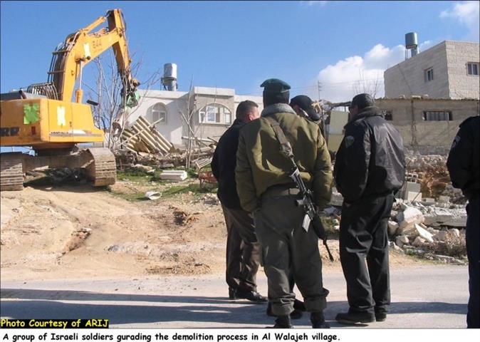
On the other hand, dozens of Palestinian houses were wiped out to make room for the construction of the Wall in place, and many other houses were also removed from the vicinity of the Wall.   

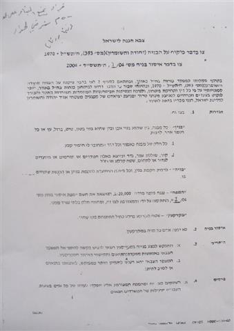
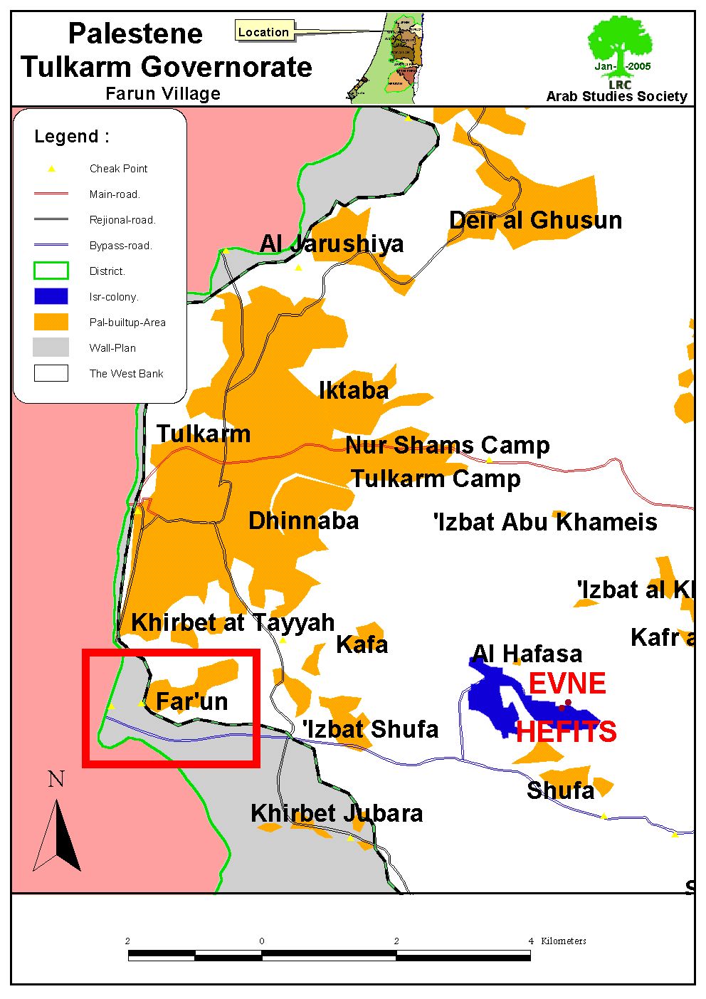
On December 18th, 2004, the Israeli army distributed new military orders stating the confiscation of more Palestinian lands to create a new security zone to the east of the Wall at  width of 500 meters, extending from the village of Aqaba in the north to the village of Al Kafriyat in the south (27 km long by 0.5 km wide strip of land -13.5 km2 -). The military orders prohibited Palestinians from using the land for any purpose under the pretext of security reasons.


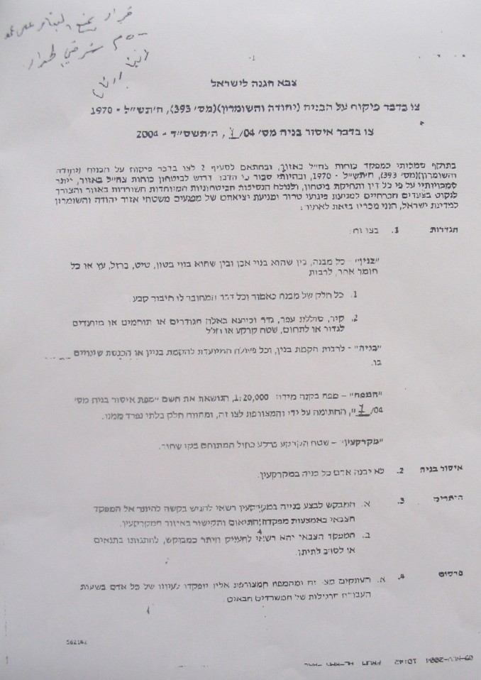
Picture 1- A copy of  the Israeli military order 

 This latest Israeli measure proves with no doubt that the real goal behind building the Wall hasn't been security, as the Israeli occupation authorities claim, rather, it has been to confiscate as much vacant lands as possible from Palestinians; thus, diminishing the possibility of  a viable Palestinian state. This, also, proves that the Wall doesn't represent fixed borders to Israel, as some people say, instead, it serves as a tool for gradual annexation of Palestinian lands under the pretext of security.


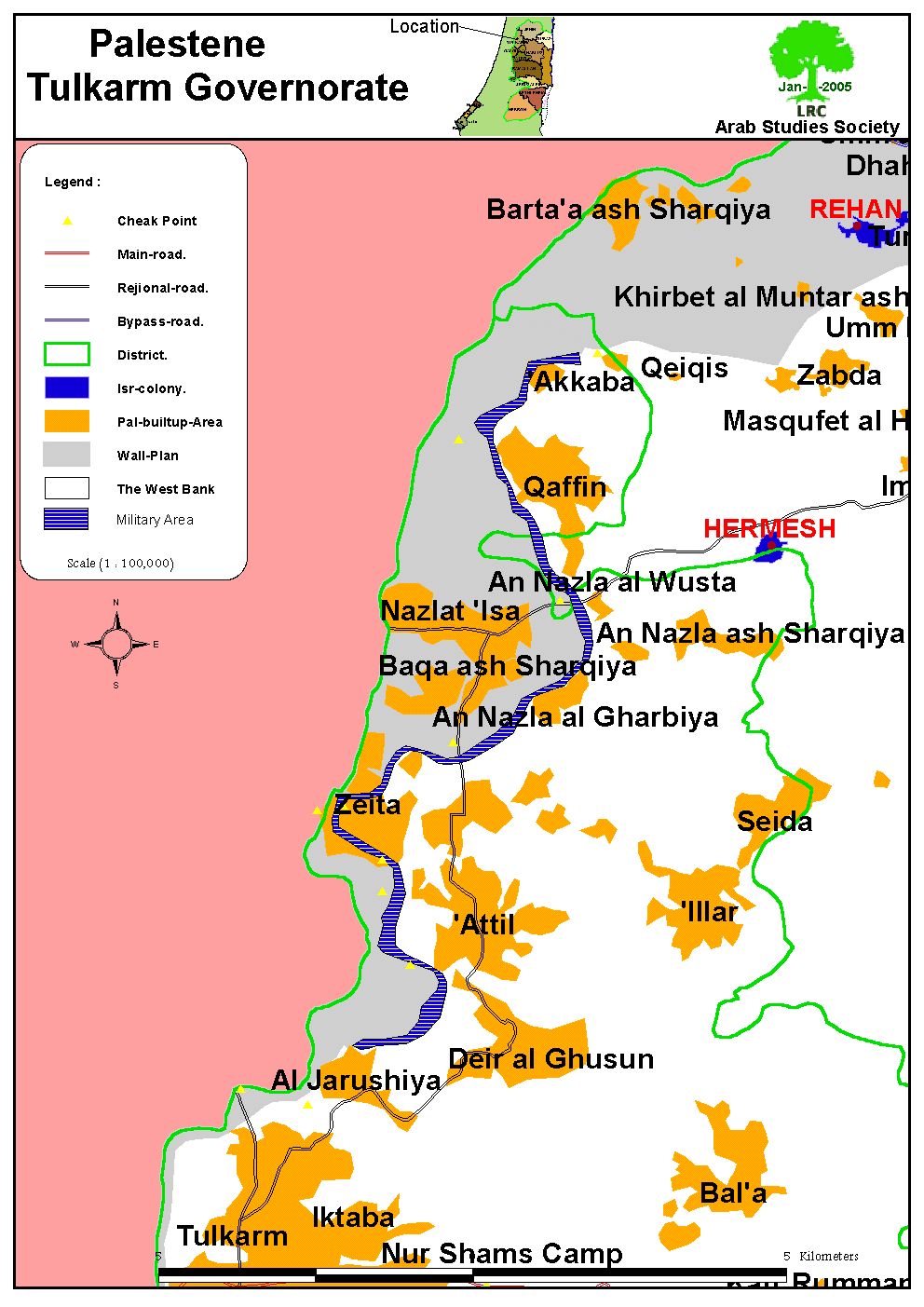
 Map 1- The newly announced military ( security ) zone along the eastern side of the Wall in Tulkarem district in shaded blue color

The following recent violations were documented by LRC field workers in the Tulkarem district: 

1- On October 15, 2004, the Israeli occupation forces confiscated 21 dunums of Faro'un village lands for military purposes and for building a tunnel for exclusive Jewish use as part of the Israeli  Segregation plan. So far, 11 tunnels of this type have been constructed in the northern parts of the West Bank.  The targeted lands are located near Al Kafriyat permanent checkpoint in the southeastern parts of the village, parcels number 8473 and 8474. Actual works in the tunnel already started on December 12.2004. The lands are owned by Mr. Mohammed Mahmud Ibrahim, Mr. Hassan Budeir and Mr. Khalil Hamdan.


Map 2- Location of Faro'un village

In addition, two houses were demolished and 10 others are awaiting demolition in Faro'un village  under the pretext of their location close to the Wall path. The owners of these houses had appealed against the demolition orders, but no avail.  

2- On November 18, 2004 the Israeli army erected a new watch tower on agricultural lands located in the western side of Shufa village. 


 Map 3- Location of Shufa village.

On the other hands, the Israeli bulldozers started on December 20, 2004 devastating Palestinian agricultural lands in the southwestern parts of Shufa village, aiming at constructing roads and tunnels for the service of Israeli settlers in the area.  

 
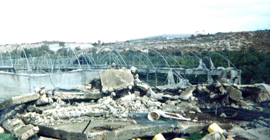
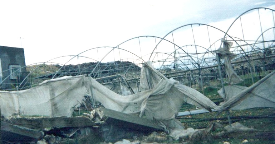
Pictures 2 & 3 – Shufa- Tulkarem: Plastic houses destroyed by Israeli army bulldozers. Photo courtesy of LRC


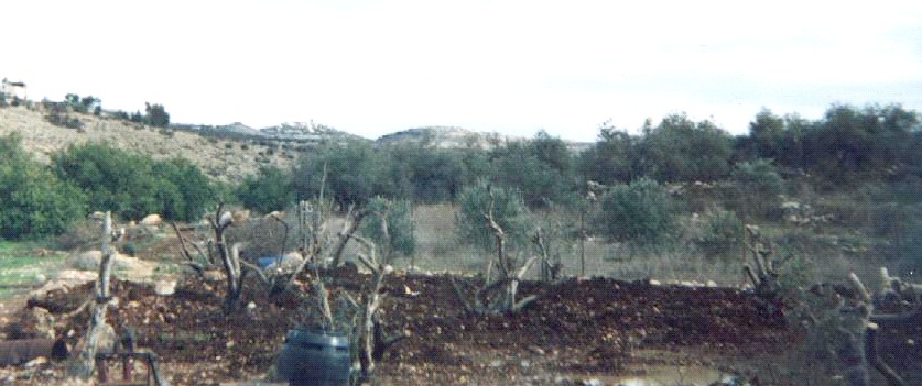
Picture 4- Shufa- Tulkarem: Some of the uprooted olive trees have been relocated and replanted by Palestinian farmers. Photo courtesy of LRC


Prepared by
 The Land Research Center
LRC


Recommended For You

مناطق نفوذ المستوطنات ودورها في إعادة تشكيل الجغرافيا الفلسطينية

by arij
April 23, 2026
0
مناطق نفوذ المستوطنات ودورها في إعادة تشكيل الجغرافيا الفلسطينية

أصدرت سلطات الاحتلال الإسرائيلي في العاشر من شهر نيسان 2026 الكراسة رقم (273)، وهي وثيقة تضم مجموعة من المناشير والأوامر والتعيينات الإسرائيلية المتعلقة بالجوانب الأمنية والعسكرية والإدارية، إضافة...

Read moreDetails

INFOGRAPHIC: Mapping Control – Israeli Militray Orders across the occupied West Bank – 2025

by arij
April 16, 2026
0

    Prepared by:   The Applied Research Institute – Jerusalem

Read moreDetails

سلطات الاحتلال الإسرائيلي تستهدف قرية الجيب بأمر عسكري جديد

by arij
March 17, 2026
0
سلطات الاحتلال الإسرائيلي تستهدف قرية الجيب بأمر عسكري جديد

نشر المسؤول عن الأملاك الحكومية وأملاك الغائبين في الإدارة المدنية الإسرائيلية في الحادي عشر من شهر اذار من العام 2026 اعلاننا مفاده نية ما يسمى " المسؤول عن...

Read moreDetails

سلطات الاحتلال الإسرائيلي تستخدم الأوامر العسكرية لتعمق المشروع الاستيطاني في الضفة الغربية المحتلة

by arij
February 26, 2026
0
سلطات الاحتلال الإسرائيلي تستخدم الأوامر العسكرية لتعمق المشروع الاستيطاني في الضفة الغربية المحتلة

تقديم منذ احتلال الضفة الغربية عام 1967، اعتمدت سلطات الاحتلال الإسرائيلي منهجية واسعة عبر استخدام الأوامر العسكرية كأداة "قانونية" لفرض الوقائع الجغرافية والديموغرافية على الأرض الفلسطينية. وأصبحت هذه...

Read moreDetails

بين مطرقة الأوامر العسكرية وسندان التقييد الجغرافي, أوامر عسكرية إسرائيلية جديدة تطال أكثر من 1000 دونم في طوباس

by arij
November 26, 2025
0
بين مطرقة الأوامر العسكرية وسندان التقييد الجغرافي, أوامر عسكرية إسرائيلية جديدة تطال أكثر من 1000 دونم في طوباس

في الحادي والعشرين من شهر تشرين الأول لعام 2025، تسلّم أهالي محافظة طوباس سلسلة من الأوامر العسكرية الإسرائيلية التي استهدفت مساحات واسعة من الأراضي الفلسطينية في المحافظة. وقد...

Read moreDetails
Next Post
Al-Walajeh Devastated by Israeli Bulldozers

Al-Walajeh Devastated by Israeli Bulldozers

LATEST NEWS

مناطق نفوذ المستوطنات ودورها في إعادة تشكيل الجغرافيا الفلسطينية

مناطق نفوذ المستوطنات ودورها في إعادة تشكيل الجغرافيا الفلسطينية

by arij
April 23, 2026
0

........................................................

التمدد الاستيطاني الإسرائيلي في الضفة الغربية المحتلة وأثره في تقويض مقومات الدولة الفلسطينية

التمدد الاستيطاني الإسرائيلي في الضفة الغربية المحتلة وأثره في تقويض مقومات الدولة الفلسطينية

by arij
April 16, 2026
0

........................................................

INFOGRAPHIC: ISRAELI SETTLER VIOLENCE IN 2025

by arij
April 16, 2026
0

........................................................

العدالة المؤجلة ورأي بلا تنفيذ: من قرار المحكمة إلى واقع الضم

أدوات غير مباشرة للاستيطان الإسرائيلي في مناطق (أ) و(ب) لإعادة تشكيل الجغرافيا والسيطرة في الضفة الغربية   

by arij
April 16, 2026
0

........................................................

flag_yellow_lowEU-PfP-Logo

This website and its content were initiated in 1993 by the Applied Research Institute – Jerusalem (ARIJ) and the Land Research Center (LRC) with the support from the European Union up until 2023. Since then, the Applied Research Institute – Jerusalem (ARIJ) has taken over the continued development and maintenance of the website. The views expressed remain solely those of ARIJ) and do not necessarily reflect those of the European Union.

© 2026 Copyright | ARIJ | All Rights reserved.

No Result
View All Result
  • Home
  • Settlements
    • New Israeli Settlements
    • Settlement Expansion
  • Israeli Violations
    • Agriculture
    • Confiscation
    • Demolition
    • Environment
    • Eviction of Palestinians
    • Settlers Attacks
  • Bypass Roads
  • Israeli Plans
  • Segregation
    • Checkpoints
    • Closure
    • Separation Plans
  • Military Orders
  • Reports
    • Daily Report
    • Monthly Report
    • Quarterly Report

© 2026 Copyright | ARIJ | All Rights reserved.