The northern part of the West Bank comprise the Palestinian governorates of Jenin Tulkarm, Qalqiliya, Nablus, Salfit, Tubas and some northern parts of Ramallah governorate, this area was called by the Israeli authorities during the years of Israeli occupation to the Palestinian Territories as the ''Shomron Area''. The area is bounded by the Armistice Line (Green line) west, Israel (north), the Jordan Valley (east) and Ramallah governorate at its southern part.
In the Oslo II interim agreement that was signed in September 1995 between the Palestinians and Israelis, the Palestinian governorates were divided into three areas A, B and C aiming at a phasing withdrawal of the Israeli forces from those areas until the accomplishment of a final status agreement.
-
Area A: the Israeli army has pulled out fully and all responsibilities for internal security and Public order are held by Palestinians.
-
Area B: Palestinians have full control over the civil administration and Israel continues to have overriding responsibility for security.
-
Area (C): the Palestinians have responsibility for civil life such as economics, health and education; however Israel retains full control over security and administration related to territory.
On the 8th of October 2003, the Israeli chief commander Mosheh Kaplenski, issued a military order prohibiting the Palestinian vehicles from using the main and secondary roads in Area (C) in the northern part of the West Bank ''Shomron Area'' for 4 days, conducted under the pretext of providing security for the Israeli settlers using these roads and at the same time linking the settlements together; thus, separating the northern districts of the West Bank such as Tubas, Salfit, Tulkarm, Qalqiliyia, Jenin and Nablus from each other and disrupting the daily life of thousands of Palestinian citizens residing in those Palestinian governorates. See map of closure
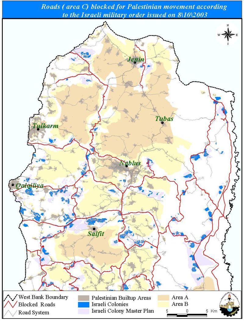
Table 1: The Palestinian population in the northern governorates.
|
Districts |
Population |
|
Tulkarm |
128870 |
|
Nablus |
250994 |
|
Salfit |
46635 |
|
Tubas |
35203 |
|
Jenin |
195112 |
|
Qalqiliya |
69235 |
Source: PCBS 1999
The military order imposed on the Palestinian cities and villages in that area hindered the ability of Palestinians to enjoy the right to live an ordinary life and resulted in the hampering and freezing of their daily activities since these roads are considered to be the main arteries of supply i.e. food and fuel. It is needles to say that the Palestinian farmers are also suffering as they are not able to reach their lands or to reach the commercial markets to sell their agricultural production.
The situation in the Occupied Palestinian Territories deteriorated very rapidly since the clashes began between the Israeli occupation troops and Palestinian civilians on the 28th of September 2000, after the provocative visit of Israeli Prime minister Ariel Sharon to Al-Aqsa Mosque in Jerusalem. Most Palestinian cities at the northern part of the West Bank have been witnessing unprecedented activities of the Israeli army in the area and have been under continuous siege and curfew since that date. Civilians are humiliated by the IOF at checkpoints and most of the times are forced to wait for long time depending on the mood of the guard on duty for minutes, hours or days. Table 2 gives the numbers of checkpoints and roadblocks in the northern Palestinian governorates including those, which have been removed recently.
Table 2:- A detailed table of the number of Roadblocks, Checkpoints, Wall Gates and Trenches in the Northern parts of the West Bank
|
District |
Roadblocks |
Permanent checkpoints |
Wall Gates |
Trenches |
|
Jenin |
9 |
13 |
1 |
2 |
|
Nablus |
9 |
9 |
8 |
– |
|
Qalqilyia |
4 |
2 |
2 |
– |
|
Tulkarm |
7 |
6 |
3 |
– |
|
Tubas |
1 |
2 |
1 |
– |
|
Salfit |
– |
2 |
4 |
– |
|
Total |
30 |
34 |
19 |
2 |
Source: ARIJ GIS database 2003
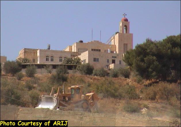
In addition, Nablus city for example, is surrounded by 24 Israeli settlements and has been a target of settlers' attacks who terrorize the Palestinians living close to those settlements and implemented a 'shoot to kill' policy in addition to severe torture and deliberate running over. Table 3 shows the Israeli settlements located in Nablus district along with date of establishment, type of settlement and settlement population.
Table 3: Israeli settlements located in Nablus district
|
settlement |
Date of Establishment |
Type of settlement |
Population 2002 |
|
Homesh |
1980 |
Mixed |
165 |
|
Shavei Shomron |
1978 |
Religious |
592 |
|
Elon Moreh |
1980 |
Religious |
1030 |
|
Mekhora |
1973 |
Non- Religious |
121 |
|
Itamar (Tel Hayim) |
1984 |
Religious |
580 |
|
Bracha |
1983 |
Religious- Urban |
743 |
|
Yizhar |
1983 |
Religious |
438 |
|
Gittit |
1972 |
Non- Religious Moshav |
174 |
|
Migdalim |
1984 |
Non- Religious |
218 |
|
Shilo |
1978 |
Religious |
1757 |
|
Eli |
1984 |
Urban |
2869 |
|
Mizpe Rahel (Shuvut Rahel) |
1992 |
Religious |
NA |
|
Matkhan Tappuah |
1978 |
NA |
324 |
|
South East of Eli |
1999 |
NA |
NA |
|
South of Shavei Shomron |
NA |
NA |
NA |
|
South Elon Moreh |
1980 |
NA |
NA |
|
South Mekhora |
NA |
NA |
NA |
|
South East far of Itamar |
NA |
NA |
NA |
|
South East near of Itamar |
NA |
NA |
NA |
|
Itamar East 2 |
NA |
NA |
NA |
|
Itamar East 1 |
NA |
NA |
NA |
|
East Gittit |
NA |
NA |
NA |
|
North West Gittit |
NA |
NA |
NA |
|
East Migdalim |
NA |
NA |
NA |
See Photos of Israeli settlements in Nablus city.

Photo 1: Shavei Shomron settlement Photo Courtesy of PEACENOW
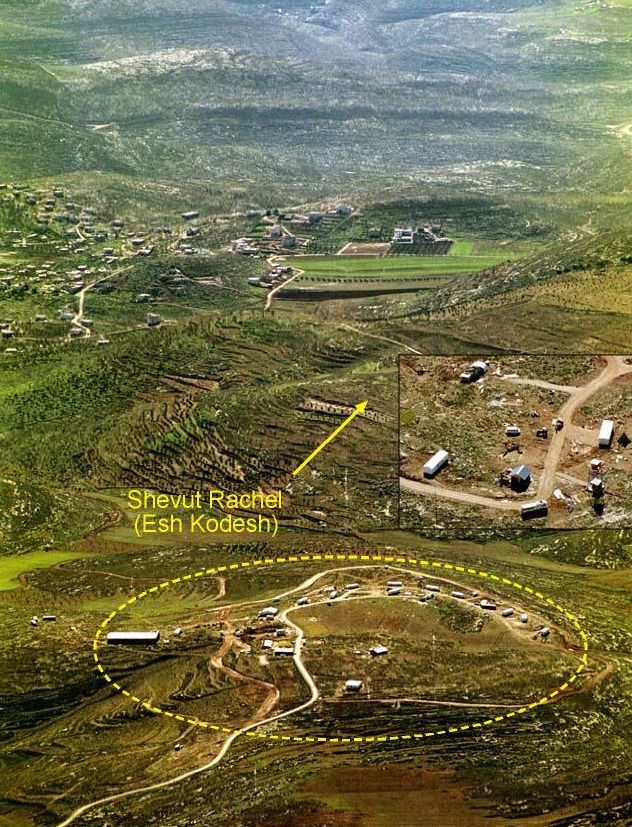
Photo 2: Shuvut Rahel settlement
Photo Courtesy of PEACENOW
The sufferings and difficulties the Palestinian citizens are facing these days by the Israeli Occupying Forces are much more serious and comprehensive and can not be illustrated in only a few words. However, the restoration of calmness, peace and security, freedom of movement should return to the region, and the harassment and siege of Palestinian normal daily life by the occupying forces should come to a complete and immediate end.
Prepared by:
The Applied Research Institute – Jerusalem