• About The Project
  • Palestine in Century
  • Selected Maps
  • Glossary
  • About ARIJ
  • About LRC
  • By Year
    • Case Studies By Year
    • Daily Report By Year
Sunday, June 7, 2026
POICA
No Result
View All Result
  • Home
  • Settlements
    • New Israeli Settlements
    • Settlement Expansion
  • Israeli Violations
    • Agriculture
    • Confiscation
    • Demolition
    • Environment
    • Eviction of Palestinians
    • Settlers Attacks
  • Bypass Roads
  • Israeli Plans
  • Segregation
    • Checkpoints
    • Closure
    • Separation Plans
  • Military Orders
  • Reports
    • Daily Report
    • Monthly Report
    • Quarterly Report
No Result
View All Result
POICA
No Result
View All Result

Lands declared as state land in Nahhalin village for future settlement expansion

April 11, 2003
in Military Orders
Lands declared as state land in Nahhalin village for future settlement expansion

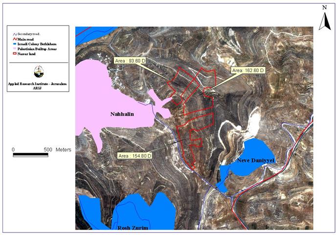
Daher Nassar, a Christian Arab, immigrated to Palestine from Lebanon at the beginning of last century with his family. He settled in Bethlehem where his ambition was to build a new life as a landowner. He managed to purchase a piece of land with an area of 400 dunums (40 hectares), south of Bethlehem city along the Hebron road and in one of the most fertile lands in the district. He registered the land in 1924 and since then is paying its taxes. See Map 1


The location of Nassar's land as well as Nahhalin village is located in the so-called Gush Etzion settlement block and is surrounded by four settlements; five hundred meters to the north lies Neve Daniel settlement, equidistance to the south is Eliazar, to the west is the Ultra Orthodox settlement of Betar Illit and to the east is the rapidly-expanding settlement of Efrat. This block is basically supported by religious Jews who consider the block to be a part of (Metropolitan Jerusalem plan).


Licenses for access to water, electricity and permits for construction have been consistently denied. The family has suffered numerous acts of persecution by the settlers from the surrounding settlements. In addition, vandalism on the land, trees, equipment and buildings as well as personal physical attacks has been recorded. Israeli soldiers have also prevented them on several occasions to work in their land and were threatened to continue doing their work.    

In 1990, a military order was issued to demolish two small buildings used by the family for storage as they were constructed without permits. This attempt was successfully blocked by the family as they got the necessary papers and permits later on.    In October 1991, Israeli surveying teams came to the land for ambiguous reasons, and one month later the Israeli government declared 300 dunums of the original 420 dunums as a (state land). The reason behind this action was to transfer the land for expanding the Israeli settlement of Neve Daniel. See copy of military order.

Military order No 88/91 declaring 300 dunums of Nassar's land as a state land
 

The Nassar family made an appeal to the committee designated by the Israeli military authorities as an advisory committee of a judicial nature that discusses petitions against the decisions of the military authorities to declare land as belonging to the state. The appeal (1& 2 )was rejected on January 29, 2002    in spite of the fact that the owners possessed land registration documents (TABU) whichprove that the land is that family belonging. 

The next step was that the family appealed to the supreme court of Israel against the decision. The appeal was to be heard on February 5th 2003, while the Supreme Court decided to delay this appeal till April 27th 2003. The declaration of private land as (state land) is a very common policy used by the Israeli Authorities in order to grab the Palestinian land under (legal) pretense.The appellants presented conclusive evidence of ownership, and that the transfer of their land to nearby settlements contradicts with the international law and international conventions.   

Prepared by:
The Applied Research Institute – Jerusalem


Recommended For You

سلطات الاحتلال الإسرائيلي بصدد الاستيلاء على موقع قبر النبي صموئيل شمال غرب مدينة القدس

by arij
May 23, 2026
0
سلطات الاحتلال الإسرائيلي بصدد الاستيلاء على موقع قبر النبي صموئيل شمال غرب مدينة القدس

 نشرت سلطات الاحتلال الإسرائيلي في الثامن عشر من شهر أيار من العام 2026 اعلانا مفاده الاستيلاء على الأراضي الفلسطينية في قرية النبي صموئيل شمال غرب القدس المحتلة. وجاء...

Read moreDetails

إقامة منطقة عسكرية عسكرية داخل أراضي (أ) في جنين

by arij
May 19, 2026
0
إقامة منطقة عسكرية عسكرية داخل أراضي (أ) في جنين

   في السابع من شهر أيار من العام 2026، وزعت سلطات الاحتلال الإسرائيلي أمرا عسكريا جديدة على أهالي مدينة جنين يقضي بمصادرة 7.2 دونما من الأراضي الفلسطينية في...

Read moreDetails

“بمساحة اجمالية 177 دونما من أرضي البيرة وبيتين”, طريق استيطاني لخدمة البؤر الاستيطانية في محافظة رام الله

by arij
May 18, 2026
0
“بمساحة اجمالية 177 دونما من أرضي البيرة وبيتين”, طريق استيطاني لخدمة البؤر الاستيطانية في محافظة رام الله

في الحادي عشر من شهر أيار من العام 2026, نشرت دائرة أراضي إسرائيل اعلانا جديدا يقضي بمصادرة المزيد من الأراضي الفلسطينية في محافظة رام الله لأغراض استيطانية في...

Read moreDetails

“في خدمة مستوطنة ناحال حيلتس”, طريق استيطاني إسرائيلي جديد على أراضي بتير وبيت جالا في محافظة بيت لحم

by arij
May 18, 2026
0
“في خدمة مستوطنة ناحال حيلتس”, طريق استيطاني إسرائيلي جديد على أراضي بتير وبيت جالا في محافظة بيت لحم

تواصل سلطات الاحتلال الإسرائيلي إحكام سيطرتها على المزيد من الأراضي الفلسطينية في الضفة الغربية المحتلة، وهذه المرة من خلال استهداف أراضي محافظة بيت لحم. ففي السادس والعشرين من...

Read moreDetails

مناطق نفوذ المستوطنات ودورها في إعادة تشكيل الجغرافيا الفلسطينية

by arij
April 23, 2026
0
مناطق نفوذ المستوطنات ودورها في إعادة تشكيل الجغرافيا الفلسطينية

أصدرت سلطات الاحتلال الإسرائيلي في العاشر من شهر نيسان 2026 الكراسة رقم (273)، وهي وثيقة تضم مجموعة من المناشير والأوامر والتعيينات الإسرائيلية المتعلقة بالجوانب الأمنية والعسكرية والإدارية، إضافة...

Read moreDetails
Next Post
Land theft continues in Hebron

Land theft continues in Hebron

LATEST NEWS

سلطات الاحتلال الإسرائيلي بصدد الاستيلاء على موقع قبر النبي صموئيل شمال غرب مدينة القدس

سلطات الاحتلال الإسرائيلي بصدد الاستيلاء على موقع قبر النبي صموئيل شمال غرب مدينة القدس

by arij
May 23, 2026
0

........................................................

إقامة منطقة عسكرية عسكرية داخل أراضي (أ) في جنين

إقامة منطقة عسكرية عسكرية داخل أراضي (أ) في جنين

by arij
May 19, 2026
0

........................................................

الآثار كأداة للضم الزاحف: مشروع القانون الإسرائيلي لإعادة هندسة الجغرافيا والهوية في الضفة الغربية

الآثار كأداة للضم الزاحف: مشروع القانون الإسرائيلي لإعادة هندسة الجغرافيا والهوية في الضفة الغربية

by arij
May 23, 2026
0

........................................................

النكبة الفلسطينية في ذكراها الثامنة والسبعين: من التطهير العرقي إلى الإبادة وإعادة هندسة الجغرافيا الفلسطينية 

النكبة الفلسطينية في ذكراها الثامنة والسبعين: من التطهير العرقي إلى الإبادة وإعادة هندسة الجغرافيا الفلسطينية 

by arij
May 18, 2026
0

........................................................

flag_yellow_lowEU-PfP-Logo

This website and its content were initiated in 1993 by the Applied Research Institute – Jerusalem (ARIJ) and the Land Research Center (LRC) with the support from the European Union up until 2023. Since then, the Applied Research Institute – Jerusalem (ARIJ) has taken over the continued development and maintenance of the website. The views expressed remain solely those of ARIJ) and do not necessarily reflect those of the European Union.

© 2026 Copyright | ARIJ | All Rights reserved.

No Result
View All Result
  • Home
  • Settlements
    • New Israeli Settlements
    • Settlement Expansion
  • Israeli Violations
    • Agriculture
    • Confiscation
    • Demolition
    • Environment
    • Eviction of Palestinians
    • Settlers Attacks
  • Bypass Roads
  • Israeli Plans
  • Segregation
    • Checkpoints
    • Closure
    • Separation Plans
  • Military Orders
  • Reports
    • Daily Report
    • Monthly Report
    • Quarterly Report

© 2026 Copyright | ARIJ | All Rights reserved.