• About The Project
  • Palestine in Century
  • Selected Maps
  • Glossary
  • About ARIJ
  • About LRC
  • By Year
    • Case Studies By Year
    • Daily Report By Year
Sunday, June 7, 2026
POICA
No Result
View All Result
  • Home
  • Settlements
    • New Israeli Settlements
    • Settlement Expansion
  • Israeli Violations
    • Agriculture
    • Confiscation
    • Demolition
    • Environment
    • Eviction of Palestinians
    • Settlers Attacks
  • Bypass Roads
  • Israeli Plans
  • Segregation
    • Checkpoints
    • Closure
    • Separation Plans
  • Military Orders
  • Reports
    • Daily Report
    • Monthly Report
    • Quarterly Report
No Result
View All Result
POICA
No Result
View All Result

Israeli Military Orders in the Wake of Sharm El-Sheikh Memorandum

September 27, 1999
in Military Orders
Israeli Military Orders in the Wake of Sharm El-Sheikh Memorandum


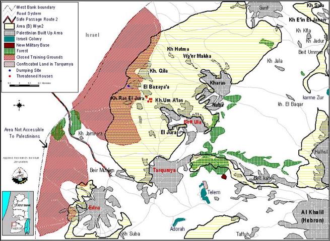
On the 15th of May 1999, 16 Israeli military orders  were approved by the Israeli military command sealing off large areas of land  in the West Bank as closed training grounds. Two of these orders concern areas  belonging to the Palestinian villages of Beit Ula (population 6,815) and Edna  (population  13,541) 10km northwest of Hebron (Figure 1).

Figure 1 Map showing Beit Ula, Edna, and the newly closed areas.

However, the villagers were not informed of these orders until  the 6th of September 1999 (i.e. after the signing of  the Sharm  El Sheikh Memorandum which was on the th of September,1999). In Beit  Ula 13,000 dunums were included in the closure, while in Edna 10,000 dunums.

Yet, according to the Sharm El Sheikh Memorandum (alternatively  known as Wye 2), around 5,000 dunums out of Beit Ula's 13,000 expropriated dunums  and 950 dunums of Edna's 10000 expropriated dunums lie in Area B (Figure 2).  In fact, a number of Palestinian houses are threatened with demolition despite  the fact that they lie in Area B. The area also includes a dumping site and a  factory employing 20 Palestinian workers (Figure 3).

Figure 2 Part of the closed area.


Figure 3 The dumping site.


Moreover, the military orders specifically state that the closure  does not apply to persons living within the designated area. Nevertheless, in  Beit Ula several  people of the Ajarmeh family living within the closure area were ordered to leave.  Prior to these orders, thirteen families were notified that their houses would  be demolished under the pretext that they were built without permits (Figure 4).

Figure 4 The houses threatened with demolition


Since most of the land is agricultural, these live-fire training  grounds affect around 200 families that make their living from agriculture and  livestock. Moreover, the proximity of the closures to  Palestinian built up areas impedes their development and natural growth.

Usually, the closing of an area for military training is limited  by a specific time period; those of Beit Ula and Edna are open-ended. Thus, claiming  that these orders are administrative and routine (i.e. independent of political  developments) is invalid. Indeed, upon closer inspection of the location of the  closures  the real reasons behind them could be foretold:

Firstly, the two closure areas flank the provisional 'Safe  Passage' route  from both sides. This works quite well with the IDF's endeavor to control the  'Safe Passage' route even in areas that are expected to be under Palestinian  authority.

Secondly, both areas lie near the Green-line (the 1949 armistice  line separating the West Bank from Israel). Locating the training grounds specifically  there denotes an Israeli intention to exclude the West Bank's border areas from  any settlement over the boundaries of the proposed Palestinian State.

Thirdly, the location of the closure near Edna produces an  additional area that is inaccessible to Palestinians by virtue of its lying between  the 'Green-line' and the closed area. Thus, Israel closes off an area practically  without doing so officially (see map).

Recently, another 40 dunums, belonging to the Saqur and Al-Muraqtan  families of Tarqumiya  village that lies between Edna and Beit Ula was expropriated for the expansion  of Telem  settlement (Figure 5 ). The villagers mentioned that the land used to be cultivated  with olive trees until five years ago when settlers uprooted them. Not only  that, but also a new military outpost overlooking  areas transferred to Area B according to Sharm El Sheikh Memorandum has been reported  in  the vicinity (Figure 6 ).

Figure 5 The expropriated land with Tarqumiya in the background.


 Figure 6 The new military outpost.


Unilateral Israeli practices such as those defy the Fourth  Geneva Convention and basic principles of international law. Nevertheless, the  Israeli  government continues to transgress the rights of Palestinians unabated.


Prepared by:
The Applied Research Institute – Jerusalem


Recommended For You

سلطات الاحتلال الإسرائيلي بصدد الاستيلاء على موقع قبر النبي صموئيل شمال غرب مدينة القدس

by arij
May 23, 2026
0
سلطات الاحتلال الإسرائيلي بصدد الاستيلاء على موقع قبر النبي صموئيل شمال غرب مدينة القدس

 نشرت سلطات الاحتلال الإسرائيلي في الثامن عشر من شهر أيار من العام 2026 اعلانا مفاده الاستيلاء على الأراضي الفلسطينية في قرية النبي صموئيل شمال غرب القدس المحتلة. وجاء...

Read moreDetails

إقامة منطقة عسكرية عسكرية داخل أراضي (أ) في جنين

by arij
May 19, 2026
0
إقامة منطقة عسكرية عسكرية داخل أراضي (أ) في جنين

   في السابع من شهر أيار من العام 2026، وزعت سلطات الاحتلال الإسرائيلي أمرا عسكريا جديدة على أهالي مدينة جنين يقضي بمصادرة 7.2 دونما من الأراضي الفلسطينية في...

Read moreDetails

“بمساحة اجمالية 177 دونما من أرضي البيرة وبيتين”, طريق استيطاني لخدمة البؤر الاستيطانية في محافظة رام الله

by arij
May 18, 2026
0
“بمساحة اجمالية 177 دونما من أرضي البيرة وبيتين”, طريق استيطاني لخدمة البؤر الاستيطانية في محافظة رام الله

في الحادي عشر من شهر أيار من العام 2026, نشرت دائرة أراضي إسرائيل اعلانا جديدا يقضي بمصادرة المزيد من الأراضي الفلسطينية في محافظة رام الله لأغراض استيطانية في...

Read moreDetails

“في خدمة مستوطنة ناحال حيلتس”, طريق استيطاني إسرائيلي جديد على أراضي بتير وبيت جالا في محافظة بيت لحم

by arij
May 18, 2026
0
“في خدمة مستوطنة ناحال حيلتس”, طريق استيطاني إسرائيلي جديد على أراضي بتير وبيت جالا في محافظة بيت لحم

تواصل سلطات الاحتلال الإسرائيلي إحكام سيطرتها على المزيد من الأراضي الفلسطينية في الضفة الغربية المحتلة، وهذه المرة من خلال استهداف أراضي محافظة بيت لحم. ففي السادس والعشرين من...

Read moreDetails

مناطق نفوذ المستوطنات ودورها في إعادة تشكيل الجغرافيا الفلسطينية

by arij
April 23, 2026
0
مناطق نفوذ المستوطنات ودورها في إعادة تشكيل الجغرافيا الفلسطينية

أصدرت سلطات الاحتلال الإسرائيلي في العاشر من شهر نيسان 2026 الكراسة رقم (273)، وهي وثيقة تضم مجموعة من المناشير والأوامر والتعيينات الإسرائيلية المتعلقة بالجوانب الأمنية والعسكرية والإدارية، إضافة...

Read moreDetails
Next Post
Expansion of Karni Shamron settlement in Tulkarm

Expansion of Karni Shamron settlement in Tulkarm

LATEST NEWS

سلطات الاحتلال الإسرائيلي بصدد الاستيلاء على موقع قبر النبي صموئيل شمال غرب مدينة القدس

سلطات الاحتلال الإسرائيلي بصدد الاستيلاء على موقع قبر النبي صموئيل شمال غرب مدينة القدس

by arij
May 23, 2026
0

........................................................

إقامة منطقة عسكرية عسكرية داخل أراضي (أ) في جنين

إقامة منطقة عسكرية عسكرية داخل أراضي (أ) في جنين

by arij
May 19, 2026
0

........................................................

الآثار كأداة للضم الزاحف: مشروع القانون الإسرائيلي لإعادة هندسة الجغرافيا والهوية في الضفة الغربية

الآثار كأداة للضم الزاحف: مشروع القانون الإسرائيلي لإعادة هندسة الجغرافيا والهوية في الضفة الغربية

by arij
May 23, 2026
0

........................................................

النكبة الفلسطينية في ذكراها الثامنة والسبعين: من التطهير العرقي إلى الإبادة وإعادة هندسة الجغرافيا الفلسطينية 

النكبة الفلسطينية في ذكراها الثامنة والسبعين: من التطهير العرقي إلى الإبادة وإعادة هندسة الجغرافيا الفلسطينية 

by arij
May 18, 2026
0

........................................................

flag_yellow_lowEU-PfP-Logo

This website and its content were initiated in 1993 by the Applied Research Institute – Jerusalem (ARIJ) and the Land Research Center (LRC) with the support from the European Union up until 2023. Since then, the Applied Research Institute – Jerusalem (ARIJ) has taken over the continued development and maintenance of the website. The views expressed remain solely those of ARIJ) and do not necessarily reflect those of the European Union.

© 2026 Copyright | ARIJ | All Rights reserved.

No Result
View All Result
  • Home
  • Settlements
    • New Israeli Settlements
    • Settlement Expansion
  • Israeli Violations
    • Agriculture
    • Confiscation
    • Demolition
    • Environment
    • Eviction of Palestinians
    • Settlers Attacks
  • Bypass Roads
  • Israeli Plans
  • Segregation
    • Checkpoints
    • Closure
    • Separation Plans
  • Military Orders
  • Reports
    • Daily Report
    • Monthly Report
    • Quarterly Report

© 2026 Copyright | ARIJ | All Rights reserved.