• About The Project
  • Palestine in Century
  • Selected Maps
  • Glossary
  • About ARIJ
  • About LRC
  • By Year
    • Case Studies By Year
    • Daily Report By Year
Tuesday, October 13, 2026
POICA
No Result
View All Result
  • Home
  • Settlements
    • New Israeli Settlements
    • Settlement Expansion
  • Israeli Violations
    • Agriculture
    • Confiscation
    • Demolition
    • Environment
    • Eviction of Palestinians
    • Settlers Attacks
  • Bypass Roads
  • Israeli Plans
  • Segregation
    • Checkpoints
    • Closure
    • Separation Plans
  • Military Orders
  • Reports
    • Daily Report
    • Monthly Report
    • Quarterly Report
No Result
View All Result
POICA
No Result
View All Result

Expansion of Karni Shamron settlement in Tulkarm

October 13, 1999
in Settlement Expansion
Expansion of Karni Shamron settlement in Tulkarm


A piece of land owned by Mr. Abdullah Bashir is being the target of colonizing activity after the colonizer Moshe Zer obtained a court order to take hold of the land. The reasoning behind the decision was the inability of Mr. Bashir to pay $130,000 fine for attacking Zer while he was leading a group of colonizers in an attempt to take hold of a land in Jabal Al Deib by force.

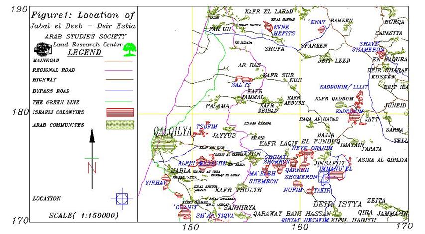
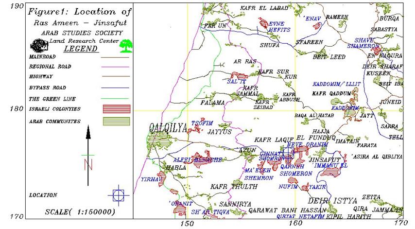
The land lies on the main road connecting Nablus and Qalqiliya. The location, called Ra'as Amer, is in the village of Jinsafut basin 11, parcel 20. The total area of the land is 42 dunums. The land is also located next to the settlement Karni Shamron where colonizers managed to get hold of an adjoining land of Mr. Bashir's where they have established a sewing factory.

Location map


Picture of factory The settlement of Karni Shamron right across the road


Mr. Bashir's land.


The colonizers attempted feverently to take hold of the land. They have proposed to pay $3 million to Mr. Bashir to sell them the land. When he refused to sell it, the colonizers used different ways to forcefully take hold of the land. In 1980, the Military Commander of the West Bank tried to annex the land to the nearby settlement of Karni Shamron (established in 1977). Mr. Bashir appealed the decision to the Israeli High Court in case number 90/81 and managed to get a decision on 22/4/1981 that annulled the actions of the Military Commander. The attempts of the colonizers cooled off after the decision while waiting for the right moment to try again. The colonizers took advantage of the inability of Mr. Bashir to pay a hefty fine of $130,000 in addition to $7,000 lawyers fees in the case of the attack of Moshe Zer and requested from the Central Court to grant Zer the right to take hold of the land until Mr. Bashir pays the fine. The Court replied positively to the decision and up until this point in time Mr. Bashir in unable to regain his land back ever since.


Prepared by
The Land Research Center
LRC


Recommended For You

Approval of a Major Expansion Plan for the Tekoa Settlement East of Bethlehem

by arij
September 1, 2026
0
Approval of a Major Expansion Plan for the Tekoa Settlement East of Bethlehem

Targets ≈6,000 dunams of Palestinian land On July 20, 2026, the so-called “Gush Etzion Settlement Regional Council” in the occupied West Bank approved a large-scale settlement master plan...

Read moreDetails

First Half of 2026
“Israeli Settlement Expansion Targets More Than 22,000 Dunams of Palestinian Land”

by arij
September 2, 2026
0
First Half of 2026  “Israeli Settlement Expansion Targets More Than 22,000 Dunams of Palestinian Land”

  Preface, Israeli settlement construction in the occupied West Bank is one of the  tools used by Israel to consolidate control over Palestinian land and reshape the Palestinian...

Read moreDetails

على ما مساحته 1006.4 دونما من أراضي بلدة يانون
“سلطات الاحتلال الإسرائيلي تشرع بتغيير نفوذ بؤرة استيطانية في الضفة الغربية المحتلة”

by arij
March 14, 2026
0
على ما مساحته 1006.4 دونما من أراضي بلدة يانون  “سلطات الاحتلال الإسرائيلي تشرع بتغيير نفوذ بؤرة استيطانية في الضفة الغربية المحتلة”

في الثاني عشر من شهر شباط من العام 2026, نشر رئيس قسم الاستيطان والتنظيم فيما يسمى "بالإدارة المدنية الإسرائيلية", الذراع الأيمن لحكومة الاحتلال الإسرائيلية اعلانا مفاده " اعلان...

Read moreDetails

حين تتقلص الخريطة: تسارع غير مسبوق في توسّع المستوطنات الإسرائيلية خلال عام 2025

by arij
February 16, 2026
0
حين تتقلص الخريطة: تسارع غير مسبوق في توسّع المستوطنات الإسرائيلية خلال عام 2025

مقدمة: - ان السياسة الاستيطانية الإسرائيلية في الضفة الغربية المحتلة هي واحدة من أكثر القضايا التي تقف عائقا في تحقيق سلام عادل وقابل للحياة في الأراضي الفلسطينية المحتلة....

Read moreDetails

حين يصبح الاستيطان سياسة دولة: 26 ألف وحدة جديدة تهدد الضفة الغربية

by arij
November 27, 2025
0
حين يصبح الاستيطان سياسة دولة: 26 ألف وحدة جديدة تهدد الضفة الغربية

في ظلّ صمتٍ دوليٍّ متزايد، يكشف معهد الأبحاث التطبيقية – القدس (أريج) عن طرح سلطات الاحتلال الإسرائيلي مخططات بناء استيطانية لأكثر من 26 ألف وحدة استيطانية جديدة في...

Read moreDetails
Next Post
The expansion of Emanuel settlement in Nablus

The expansion of Emanuel settlement in Nablus

LATEST NEWS

“في خدمة المستوطنات والبؤر الاستيطانية الإسرائيلية”  سلطات الاحتلال تصدر 32 أمرًا عسكريًا لإنشاء خطوط مياه جديدة

“في خدمة المستوطنات والبؤر الاستيطانية الإسرائيلية”
سلطات الاحتلال تصدر 32 أمرًا عسكريًا لإنشاء خطوط مياه جديدة

by arij
September 29, 2026
0

........................................................

سلطات الاحتلال الإسرائيلي تستولي على 370 دونما من أراضي أبو ديس بذريعة أملاك حكومية

سلطات الاحتلال الإسرائيلي تستولي على 370 دونما من أراضي أبو ديس بذريعة أملاك حكومية

by arij
September 23, 2026
0

........................................................

سلطات الاحتلال الإسرائيلي تتم رسميا اعداد المخطط الهيكلي للبؤرة الاستيطانية «أفيا» (يتسيف/شديما سابقًا) شرق مدينة بيت ساحور

سلطات الاحتلال الإسرائيلي تتم رسميا اعداد المخطط الهيكلي للبؤرة الاستيطانية «أفيا» (يتسيف/شديما سابقًا) شرق مدينة بيت ساحور

by arij
September 17, 2026
0

........................................................

الاحتلال الإسرائيلي يخصص 1627 دونما لصالح البؤرة الاستيطانية “كيدا ” في محافظة نابلس

الاحتلال الإسرائيلي يخصص 1627 دونما لصالح البؤرة الاستيطانية “كيدا ” في محافظة نابلس

by arij
September 10, 2026
0

........................................................

flag_yellow_lowEU-PfP-Logo

This website and its content were initiated in 1993 by the Applied Research Institute – Jerusalem (ARIJ) and the Land Research Center (LRC) with the support from the European Union up until 2023. Since then, the Applied Research Institute – Jerusalem (ARIJ) has taken over the continued development and maintenance of the website. The views expressed remain solely those of ARIJ) and do not necessarily reflect those of the European Union.

© 2026 Copyright | ARIJ | All Rights reserved.

No Result
View All Result
  • Home
  • Settlements
    • New Israeli Settlements
    • Settlement Expansion
  • Israeli Violations
    • Agriculture
    • Confiscation
    • Demolition
    • Environment
    • Eviction of Palestinians
    • Settlers Attacks
  • Bypass Roads
  • Israeli Plans
  • Segregation
    • Checkpoints
    • Closure
    • Separation Plans
  • Military Orders
  • Reports
    • Daily Report
    • Monthly Report
    • Quarterly Report

© 2026 Copyright | ARIJ | All Rights reserved.