• About The Project
  • Palestine in Century
  • Selected Maps
  • Glossary
  • About ARIJ
  • About LRC
  • By Year
    • Case Studies By Year
    • Daily Report By Year
Friday, June 6, 2025
POICA
No Result
View All Result
  • Home
  • Settlements
    • New Israeli Settlements
    • Settlement Expansion
  • Israeli Violations
    • Agriculture
    • Confiscation
    • Demolition
    • Environment
    • Eviction of Palestinians
    • Settlers Attacks
  • Bypass Roads
  • Israeli Plans
  • Segregation
    • Checkpoints
    • Closure
    • Separation Plans
  • Military Orders
  • Reports
    • Daily Report
    • Monthly Report
    • Quarterly Report
No Result
View All Result
POICA
No Result
View All Result

Wadi Al-Teen Quarry and the Systematic Expropriation of Palestinian Natural Resources

March 12, 1997
in Confiscation
Wadi Al-Teen Quarry and the Systematic Expropriation of Palestinian Natural Resources


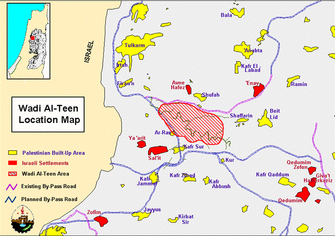
Wadi Al-Teen is a large valley located 5 kilometers southeast of Tulkarm city and 4.5 kilometers to the east of the Green Line which separates the West Bank from Israel (Map 1). The valley is characterized by a rocky surface and sharp slopes, with various locations planted with orchard and olive trees. Wadi Al-Teen represents an important natural grazing area which supports many livestock farmers in neighboring Palestinian villages. It also serves as the main catchment area for runoff rainwater. This runoff rainwater feeds large agricultural areas located at the flat end of the valley near Tulkarm city (Map 2, aerial photo). The size of Wadi Al-Teen catchment area is estimated at 80 km2 and collects a minimum of 18 million cubic meters of water per year, a major source for water for agricultural production in the area.

 
Map 1: Location Map of Wadi Al-Teen

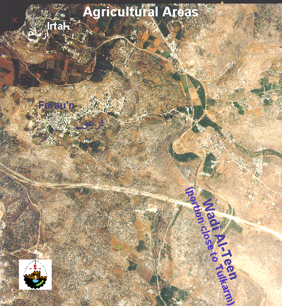
Map 2:Agricultural Areas Fed by Wadi Al-Teen Runoff Water (309 k bytes)


On 11 August 1994, the Israeli Central Planning Office for 'Judea and Samaria', located in Beit El, proposed the expropriation of 968.5 hectares of Wadi Al-Teen area to be utilized as quarries for private Israeli companies. Although a major portion of the land to be expropriated is privately owned by Palestinians, the Israeli Highest Planning Committee approved the proposal and it was thereafter referred to as Detailed Planning Scheme 24/52. The Israeli Highest Planning Committee based its decision on article 20/24 (1) of the 1966 Jordanian Town Planning and Building Law Number 79, which was in use before the Israeli occupation of the West Bank.

The quarry plan includes the confiscation, with no consultation or compensation, of 968.5 hectares (2,421 acres) of land belonging to the five Palestinian villages of Shufah, Saffarin, Kur, Kafr Sur, and Ar-Ras (Map3). The confiscated area will be used by private Israeli companies to quarry and extract granite stone, open roads to connect the quarry area with the main Tulkarm – Kuf Sur area, and reserve land tracts as a buffer zone for variety of purposes (Table 1).


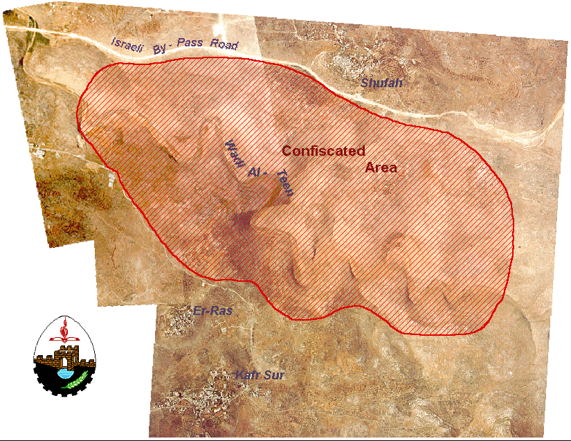
Map 3:The Planned Wadi Al-Teen Quarry (aerial photo 426 k bytes)


Table 1: Planning Scheme of Wadi Al-Teen Quarry

Purpose

Area in Hectares

Percentage

Quarry

341.5

35.3

Buffer Zone

548.0

56.6

'Green Area'

71.0

7.3

Roads

8.0

0.8

Total

968.5

100.0

1 hectar = 2.5 acres


Israel recently began to implement the quarry plan despite formal and public Palestinian protest. Several objections were submitted to Israeli courts by Palestinians against the project supported with land ownership deeds, however, no response was given (Al-Quds Newspaper, 3 December 1996).

The construction of a quarry in Wadi Al-Teen will undoubtedly bring environmental degradation, threaten the biodiversity and wildlife in the area, close off major natural grazing and agricultural areas, and deprive Palestinian farmers of runoff water used for irrigation. Furthermore, the plan will adversely affect the living environment in neighboring Palestinian villages due to dust and other types of air pollution. Most important, this project allows Israel to exploit Palestinian stone, the main natural raw material in the West Bank. As the West Bank lacks any other major natural raw materials, granite, as well as other stone types, are considered the white oil of Palestine and the only abundant raw material available to support the Palestinian economy.

The Wadi Al-Teen quarry is not a unique incident but one of seven Israeli quarries which Israel had created in the West Bank (Map 4). These quarries, occupying an area of 1,673.3 hectares (4,183 acres), are built on land that Israel confiscated after the signing of the Oslo I agreement of 1993. These quarries represent a systematic pirating of Palestinians' natural resources and the destruction of their environment. The quarries are also blatant violations of international law and specifically the Fourth Geneva Convention. As an occupying power, Israel is prohibited by international law to expropriate and utilize the West Bank's natural resources unless it is for the sole benefit of the occupied population, the Palestinian people.

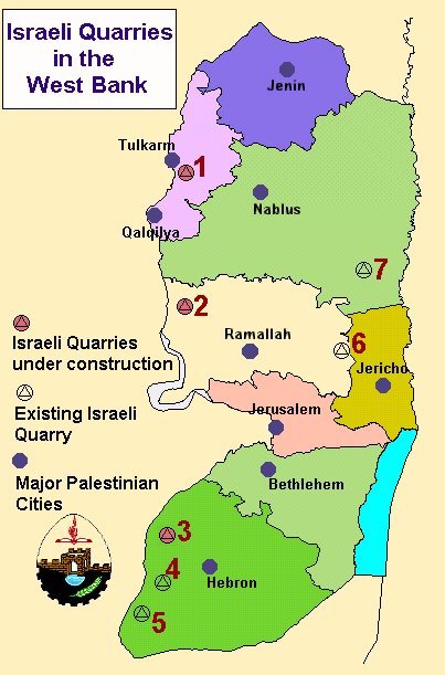
Map 4: Israeli Quarries in the West Bank


Prepared by:
The Applied Research Institute – Jerusalem

Recommended For You

هدم وسرقة بيت تعبئة زراعي في كردلة – ضربة موجعة للاقتصاد المحلي

by arij
January 21, 2025
0
Demolition and Theft of an Agricultural Packing Facility in Kardala: A Severe Blow to the Local Economy

تفاصيل الانتهاك: منذ احتلال الضفة الغربية عام 1967، باتت قرية كردلة هدفًا رئيسيًا للاحتلال الإسرائيلي الذي يسعى بكل الوسائل لتفريغها من سكانها الأصليين، تمهيدًا للاستيلاء على أراضيها ومواردها....

Read moreDetails

Demolition and Theft of an Agricultural Packing Facility in Kardala: A Severe Blow to the Local Economy

by arij
January 20, 2025
0
Demolition and Theft of an Agricultural Packing Facility in Kardala: A Severe Blow to the Local Economy

Since the occupation of the West Bank in 1967, the village of Kardala has become on the list of the prime and major targets for the Israeli occupation,...

Read moreDetails

تستهدف ما يزيد عن6900, تسجيل الأراضي في القدس في خدمة مشروع الاستيطان الإسرائيلي وشرعنة الاستيلاء على الأرض

by arij
May 8, 2023
0
POSITION PAPER: A Land Mine before the “Two State Solution

   تسوية الأراضي هي أحدى اهم حيل إسرائيل لتهويد القدس الشرقية، وقد كان القضاء الإسرائيلي قد أصدر إعلاناً عن بدء "تسوية أراضٍ" بمسميات وأرقام جديدة للأحواض في احياء...

Read moreDetails

الاحتلال يصادر محتويات منتزه في جبل السنداس جنوب مدينة الخليل

by arij
September 14, 2022
0
الاحتلال يصادر محتويات منتزه في جبل السنداس جنوب مدينة الخليل

  الانتهاك: مصادرة مواد منتزه. تاريخ الانتهاك: 31/08/2022. الموقع: جبل السنداس/ مدينة الخليل. الجهة المعتدية: الإدارة المدنية التابعة للإحتلال. الجهة المتضررة: المواطن يسري الجمل. التفاصيل: أقدمت سلطات الاحتلال...

Read moreDetails

The Occupation Confiscates Properties of a Park Owner at Hebron City

by arij
September 15, 2022
0
الاحتلال يصادر محتويات منتزه في جبل السنداس جنوب مدينة الخليل

  Violation: Confiscation of park properties. Date: August 31st 2022. Location: As-Sindas Mountain / Hebron city. Perpetrators: The Israeli Civil Administration. Victims: Citizen Yusri Aj-Jamal. Description: Wednesday ,...

Read moreDetails
Next Post
A New Israeli Colony in the Southern Vicinity of Bethlehem  Givat Hazayit (Um Tale’ Hill)

A New Israeli Colony in the Southern Vicinity of Bethlehem
Givat Hazayit (Um Tale' Hill)

LATEST NEWS

ثمانية وخمسون عاما على حرب 1967: تقويض حل الدولتين

ثمانية وخمسون عاما على حرب 1967: تقويض حل الدولتين

by arij
June 5, 2025
0

........................................................

58 Years since the 1967 War: Undermining the Two-State Solution

58 Years since the 1967 War: Undermining the Two-State Solution

by arij
June 5, 2025
0

........................................................

Infographic – The Geopolitics of Area C

ورقة موقف: إسرائيل تصادق على استئناف تسجيل الأراضي في الضفة الغربية

by arij
June 5, 2025
0

........................................................

77 عام  على النكبة الفلسطينية: حاضر مستمر لا تاريخ منتهي

77 عام  على النكبة الفلسطينية: حاضر مستمر لا تاريخ منتهي

by arij
June 2, 2025
0

........................................................

flag_yellow_lowEU-PfP-Logo

This website has been produced with the assistance of the European Union. The contents of this publication are the sole responsibility of ARIJ & LRC and can in no way be taken to reflect the views of the European Union.

© 2025 Copyright ARIJ . All Rights reserved. .

No Result
View All Result
  • Home
  • Settlements
    • New Israeli Settlements
    • Settlement Expansion
  • Israeli Violations
    • Agriculture
    • Confiscation
    • Demolition
    • Environment
    • Eviction of Palestinians
    • Settlers Attacks
  • Bypass Roads
  • Israeli Plans
  • Segregation
    • Checkpoints
    • Closure
    • Separation Plans
  • Military Orders
  • Reports
    • Daily Report
    • Monthly Report
    • Quarterly Report

© 2025 Copyright ARIJ . All Rights reserved. .