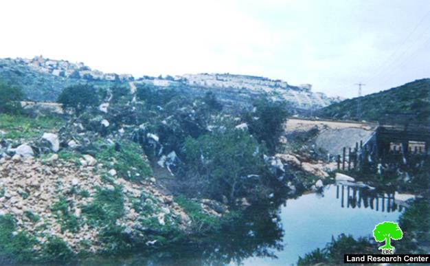
Wadi Qana polluted by Israeli settlements
( Photo 1: in the background is the settlement of Emmanuel, in the foreground is the swage water canal coming from the settlement) Wadi Qana is located in ...
Read moreDetails( Photo 1: in the background is the settlement of Emmanuel, in the foreground is the swage water canal coming from the settlement) Wadi Qana is located in ...
Read moreDetails( Photo 1: in the background is the settlement of Emmanuel, in the foreground is the swage water canal coming from the settlement)) Wadi Qana is located in ...
Read moreDetailsThe Israeli hunger for Palestinian lands has no limits. It is rarely that a day passes with the occupation carrying out a confiscation here or there directly or ...
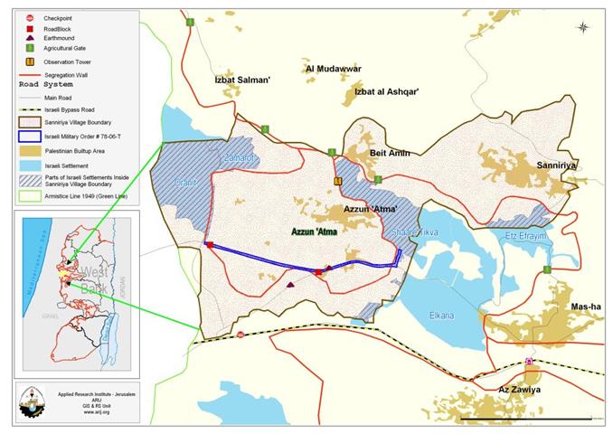
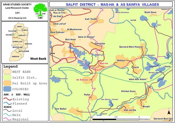
Read moreDetails'Azzun 'Atma : location and Population The village of 'Azzun 'Atma (population 1791-PCBS 2005) is located about (2.75 km) east of the Green Line and about (8.40Km) ...
Read moreDetailsOn September 4, 2006, the Israeli Forces tossed in the fields of Al Khader and Artas villages a new military order # (77/06/T) stating the confiscation of large ...
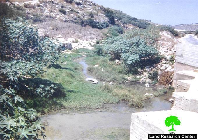
Read moreDetailsPhoto 1: Wadi Beit Amin, Qalqiliya: Palestinian agricultural land flooded with swage water from Israeli settlements Waste and swage water pouring from Israeli settlements has transformed Wadi Beit ...
Read moreDetailsThe Israeli occupation forcers (IOF) issued a military decree stating the confiscation of at least 200 square meters from the lands of the villages of Qarut and Jalud, ...
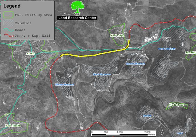
Read moreDetailsThe Israeli occupation forces decided to confiscate 8 dunums of land from Kafr Laqif and Hajja village/ Qalqiliya governorate for the purpose of establishing a military base and ...
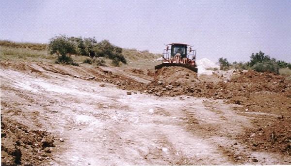
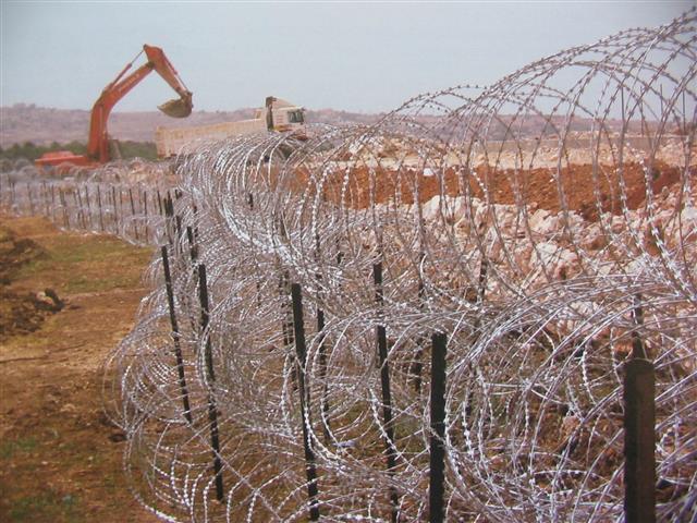
Read moreDetails(Photo 1: the yellow section of the Wall currently under construction) The Israeli army bulldozers resumed works in the construction of the Annexation and Expansion Wall in the ...
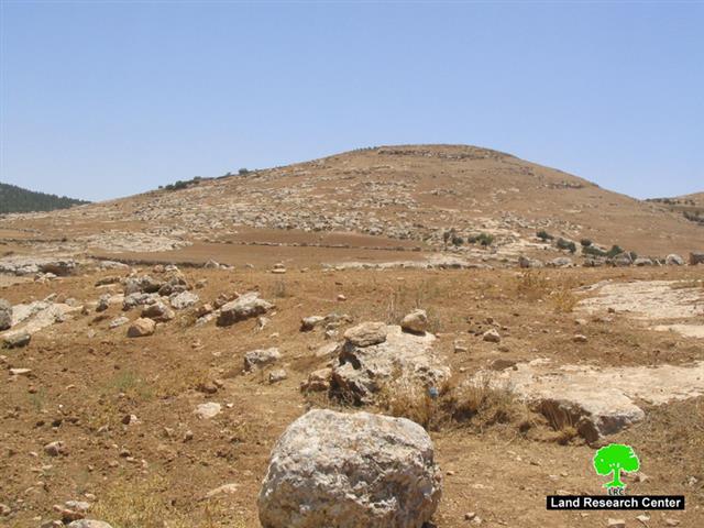
Read moreDetailsPhoto 1: Khirbet Attuwani- Hebon: the Tel targeted for confiscation The commander of the Israeli occupation forces (IOF) in the West Bank, general Ya'ir Golan, issued on ...
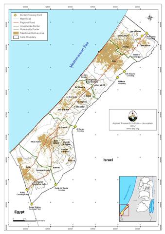
Read moreDetailsThe Gaza Strip has been going through harsh aggressive measures since June 25, 2006, when the Israeli forces launched the Summer Rains operation that followed a military operation ...
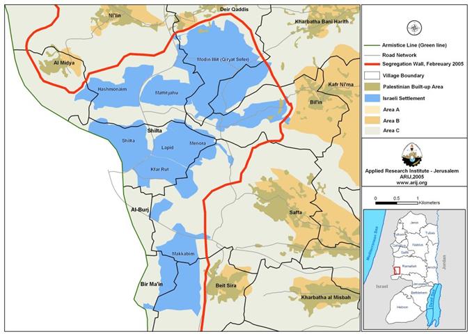
Read moreDetailsLocation; The Modi'in Block is a group of Israeli-Jewish settlements located approximately 8 Km northwest of Jerusalem along the 1949 Armistice Line. The block contains 8 settlements listed ...
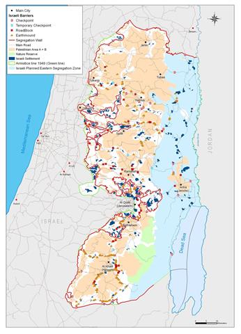
Read moreDetailsBackground: The eastern part of the West Bank includes the Jordan Valley and the upper part of the Dead Sea western shores and occupies an area of 1664 ...
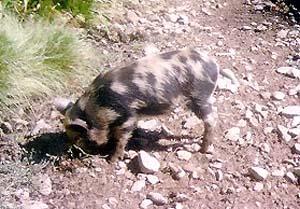
Read moreDetailsIsraeli occupation authorities have released a large number of wild pigs in Deir Ballut which led to the spoilage of agricultural crops especially the newly-planted. This fact has ...
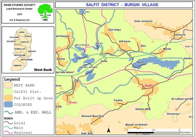
Read moreDetailsThe village of Bruqin is located 13 kilometers to the west of the city of Salfit. It is considered to be one of the villages that depend mainly ...
Read moreDetailsThis report highlights the chronology of events concerning the Israeli Colonizing Activities in the West Bank, Jerusalem and the Gaza Strip that occurred during the months of April to June ...
Read moreDetailsThe Israeli occupation authorities announced last June tenders to construct 54 housing units for Jewish families in the southern part of Elkana colony at the expense of the ...
Read moreDetailsIsraeli bulldozers continue to devastate agricultural lands in the village of Sabastiya - Nablus governorate for the purpose of building a new alleged 'security' fence around the settlement ...
Read moreDetails(Photo 1: Wall works in the western parts of Hebron governorate) The Governorate of Hebron is located in the southern part of the West Bank. It is ...
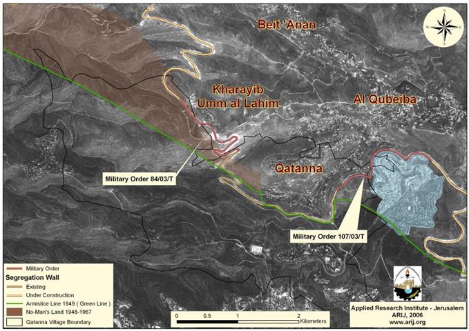
Read moreDetailsQatanna village: Location and Population Qatanna, a Palestinian village located 12 Kilometers to the northwest of Jerusalem city, has an area of 3555 dunums and is 650 meters ...
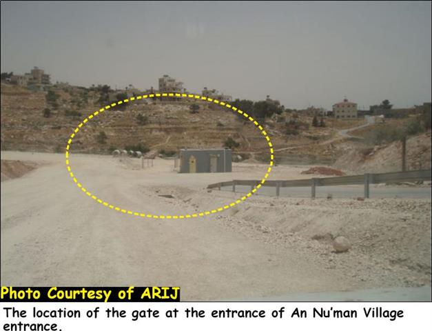
Read moreDetailsThe Israeli occupation authority, as part of its segregation Wall plan for the northwestern Bethlehem area, has installed a gate at the entrance to An Nu'man village which ...
Read moreDetailsThe Israeli Government endorsed on April 30, 2006, an updated Wall plan which included changes in a number of locations which constituted major obstacles to the resumption of ...
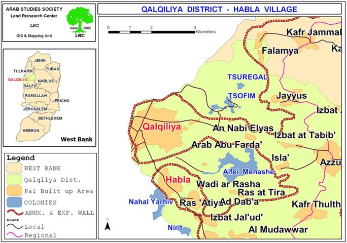
Read moreDetailsStarting from April, 2006, the Israeli occupation forces began to tighten measures on farmers and citizens of the village of Habla, Qalqiliya, by terrorizing and preventing them from ...
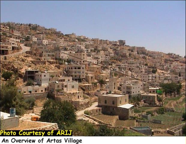
Read moreDetailsA glance about Artas village The historical village of Artas is located one and a half kilometers to the southwest of Bethlehem city center and 15 kilometers from ...
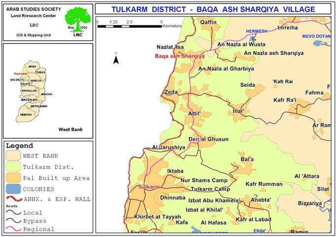
Read moreDetailsLocation The village of Baqa Al Sharqiya is located 12 kilometers northwest of the city of Tulkarem. It is located right on the Green Line and most ...
Read moreDetails
........................................................

........................................................

........................................................

........................................................

This website and its content were initiated in 1993 by the Applied Research Institute – Jerusalem (ARIJ) and the Land Research Center (LRC) with the support from the European Union up until 2023. Since then, the Applied Research Institute – Jerusalem (ARIJ) has taken over the continued development and maintenance of the website. The views expressed remain solely those of ARIJ) and do not necessarily reflect those of the European Union.