- Violation: serving stop-work and demolition
- Location: Qusra village-Nablus
- Date: February 10, 2016
- Perpetrators: Planning and Construction Committee- Israel Civil Administration
- Victims: 22 Palestinian families
Details:
The village of Qusra is relative to the suburbs of Nablus city; its people depend on the agricultural sector as a main source of income, especially during the current economical hardships the area goes through.
The Israeli occupation invests all efforts to take over lands from the village to be annexed to the nearby colonies and outposts of Yesh Kodish, Ahya and Heyoval , which have been reported to grow rapidly.
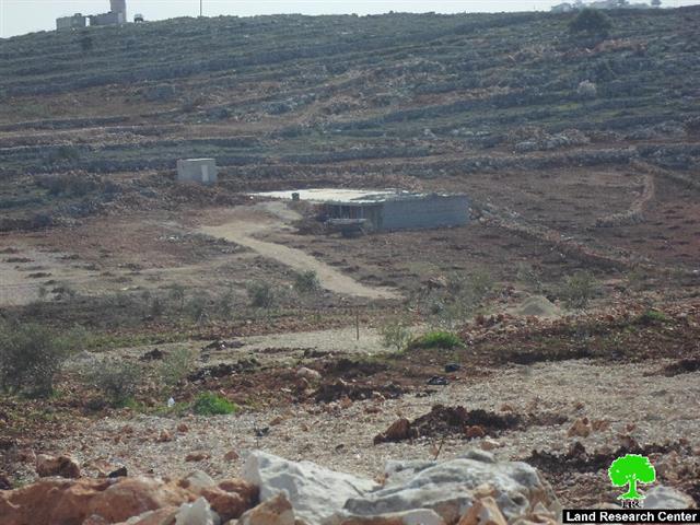
A force from the Israeli Occupation Army accompanied by a staff from the Planning and Construction Committee- Israel Civil Administration raided on February 10, 2016 the eastern and southern parts of Qusra village, south Nablus and delivered an order stating "final opportunity to object to demolition" on an agricultural road. Noteworthy, the objection period was three days only.
It should be marked that the targeted road is of 800m in length and was opened on March 2015, it starts off from the area of Basaltah and ends up in Ras Al-Khalleh, serving 150 dunums of lands.
The chairman of Qusra village council, Abdelatheem Al-Wadim said that the road was implemented through Premiere Urgenece International PUI organization.
In the same context, the occupation served citizen Samir Hasan a military order stating "additional opportunity to object demolition" within three day period. The order targeted an agricultural room (25m2) that was funded by ACTED organization to serve the citizen's 15 dunum land.
Stop-work orders:
In the same context, the Israeli Occupation Forces served stop-work orders on agricultural rooms (16m2each) in the area of Ras Al-Nakhil. The structures belong to Mohammad Oudeh and Fathallah Abu Rabada and were constructed in 2016 through Ministry of Wall and Colonization Affairs under the supervision of Qusra village council.
The rooms are reported to serve around 35 dunums that recently underwent reclamation to protect them from colonial expansionist and takeover plans.
Also, Citizen Rabee Abu Bakir was served a stop-work order on his agricultural room (12m2) founded in the area of Al-Marah 2. Noteworthy, the room was established with funds from the French Consulate through Qusra village council to serve 12 agricultural dunums.
Not only, the occupation delivered a stop-work order on water well (550m3) that serves 170 dunums of olive groves belonging to 15 families from the village. The well was established within the "Land and Water Resource Management for Agriculture development in the West Bank" funded by the Netherland Representative Office NRO.
According to the order, the affected people were given until February 23, 2016 to complete all licensing procedures. This date comes in time with the hearing session of the Planning and Construction Committee in the court of Beit El colony to consider the status of the notified structures. The following table shows information about the notified structures:
| citizen | Family | No. of notified structures | Aream2 | Serving an area ofm2 | Nature of notified structure | No. of military order | Type of military order | Remarks | Photo |
| Owners and farmers of Qusra | 1 | 800 | 150 | Agricultural road | 392949 | "additional opportunity to object demolition" order | Funded by PUI | 1 | |
| Samir Hasan | 9 | 1 | 25 | 15 | Agricultural room | 390899 | "additional opportunity to object demolition" order | Funded by ACTED and implemented by PUI | 4 |
| Mohammad Oudeh | 4 | 1 | 16 | 20 | Agricultural room | 200987 | Stop-work | Funded by Ministry of Wall Affairs | 2 |
| Fathallah Abu Rabadah | 7 | 1 | 16 | 15 | Agricultural room | 200988 | Stop-work | Funded by Ministry of Wall Affairs | 3 |
| Rabee Abu Bakir | 6 | 1 | 12 | 12 | Agricultural room (still under construction) | N/A | Stop-work | Funded by French Consulate | 5 |
| Water well | 73 | 1 | 550m3 | 170 | Water pool | 200986 | Stop-work | Funded by Netherlands Representative Office | 6 |
| Total | 99 | 6 | 69 | 382 |
Source : Field observation- Department of Monitoring Israeli Violations- Land Research Center-2016

The targeted structures are reported to serve 380 dunums belonging to residents from Qusra village, which is surrounded by a number of outposts relative o Shevut and Shilo colonies. Qusra is also edged by the bypass road number 505 and Migdalim colony from the northeast. This proves that the Planning and Construction Committee- Israel Civil Administration intend to intensify stop-work and demolition orders for the sake of displacing people from their lands to take them over.
About Qusra:[i]
It is located 23 km to the south of Nablus city and is administered by Qusra village Council. Qusra is surrounded by Jurish (south), Talfit (west), Majdal Bani Fadil (east), and Mizpe Rachel colony (south).
Qusra is inhabited by 5644 people according to 2014 PBS population projections. Its total area is 8886 dunums that include 775 dunums of built up area.
The Israeli occupation confiscated 223 dunums of the village lands for the sake of:
- Migdalim colony that devoured 155 dunums. It was built in 1984 and is inhabited by 152 colonists.
- Bypass road no. 508 that took over 68 dunums.
According to Oslo Accords, Qusra is divided into area B (4323 dunums) and area A (4563 dunums).
[1] Source: Geographic Information System- Monitoring Israeli Violations Team- Land Research Center
Prepared by
The Land Research Center
LRC


