ما بعد مؤتمر أنابوليس … عطاءات اسرائيلية جديدة لاضافة وحدات سكنية جديدة في مستوطنة أبو غنيم
بالرغم من تعهد الحكومة الاسرائيلية في مؤتمر أنابوليس بالالتزام بخارطة الطريق و التي تدعو الى تجميد كافة أشكال ...
بالرغم من تعهد الحكومة الاسرائيلية في مؤتمر أنابوليس بالالتزام بخارطة الطريق و التي تدعو الى تجميد كافة أشكال ...
On December 4, 2007, the Israeli Ministry of Housing and Construction submitted a tender to build new 307 Israeli housing ...
For a country that keeps claiming that it is the only liberal and democratic place in the Middle East, Israel ...
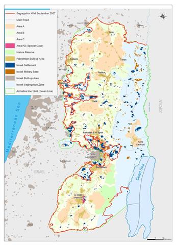
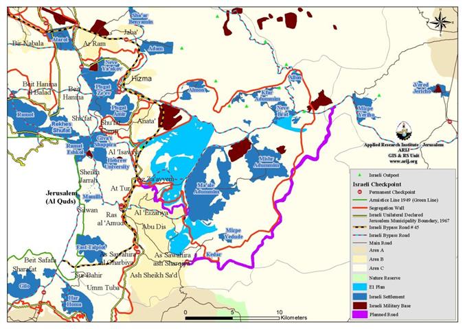
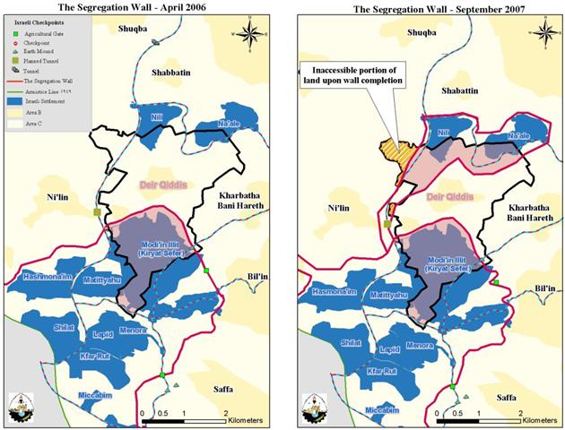
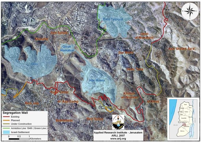
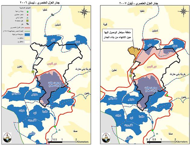
On September 12, 2007 the Israeli government published another revised route of the Segregation Wall in the West Bank. The ...
For the past 40 years of military occupation of the West Bank the Israeli occupation authorities have continued to deprive ...
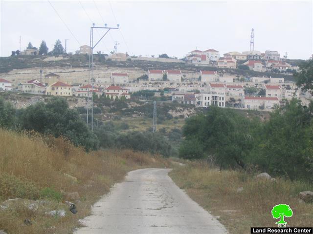
On November 21, 2007, the Israeli army circulated notifications to Palestinian residents of Um Rukbeh area southeast of Al Khader ...
لمحة عامة بحجة منع العمليات التخريبية ضد السكان الإسرائيليين ووفقا للدواعي الأمنية , أعلنت السلطات الإسرائيلية عن ...
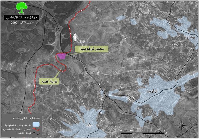
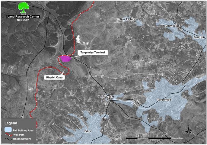
During the preparation for the Annapolis international peace summit, the representative of the government of the State of Israel, the ...
Introduction Under the pretext of security necessities and preventing terrorist attacks against the Israeli residents, Israel, had started to construct ...
The Jewish lobby in the USA continues to explore new means to provide financial support to illegal Jewish settlements in ...
يواصل اللوبي الصهيوني في الولايات المتحدة الامريكية طرح مبادرات جديدة لتوفيرالدعم المالي لبرنامج الاستيطان اليهودي عن طريق المؤسسات الاهلية و ...
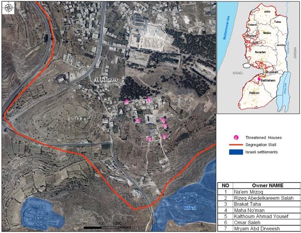
On October 27th, 2007, the Israeli occupation authorities sent halt-construction warnings to the owners of four houses and two stores ...
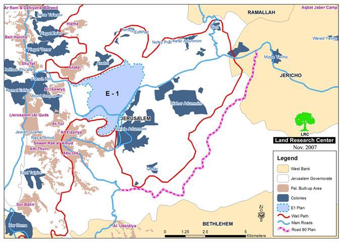
Three years have passed to the landmark 'Advisory Opinion' issued by the International Court of Justice (ICJ) regarding the under ...
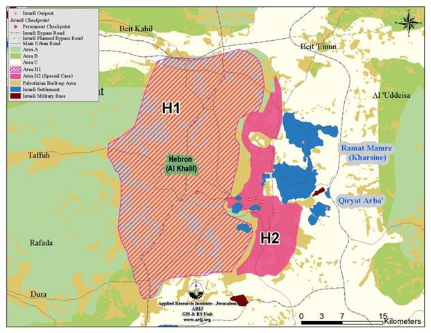
Hebron Governorate is located at the southern part of the West Bank. It has a total area of 1067.5 km ...
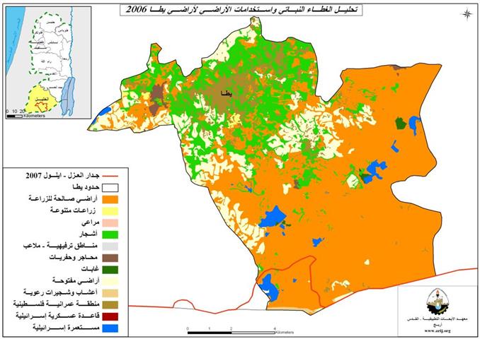
مدينة يطا: موقع وسكان تعد مدينة يطا إحدى أكبر مدن محافظة الخليل من حيث عدد السكان والمساحة إذ تشكل ...
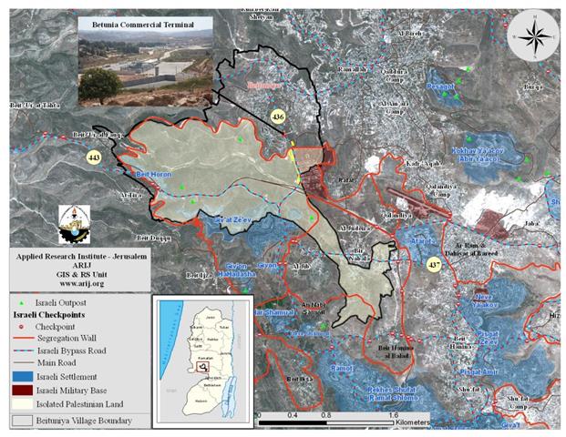
The Palestinian Town of Betunia is located some 2.7 kilometers south of Ramallah city and 14 kilometers north of East ...
INTRODUCTION Israeli occupation authorities continued to commit more war crimes against the occupied Palestinian territories and against the Palestinian civilians ...
Deir Qiddis, Location and Population The Palestinian village of Deir Qiddis is located 16 kilometers to the southwest of Ramallah ...
في 29 تشرين الاول/ اكتوبر 2007 هدمت قوات الاحتلال الإسرائيلية ما مجموعه 48 بيتا من الصفيح والخيام ...
On October 29, 2007, the Israeli occupation forces demolished houses made of tents, barracks, bowers and caves for 48 nucleus ...
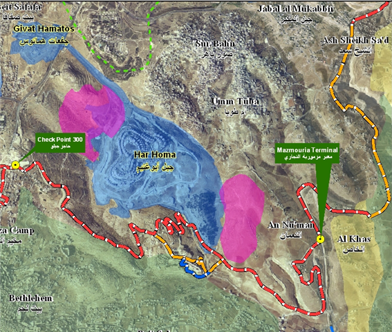
Abstract Har Homa (known to Palestinians 'Abu Ghneim Mountain') is an Illegal Israeli settlement located less than two kilometers north ...
It became evident that the under construction Israeli Segregation Wall is an interpretation of the long dragged Israeli policy of ...
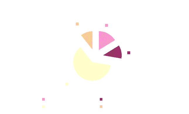
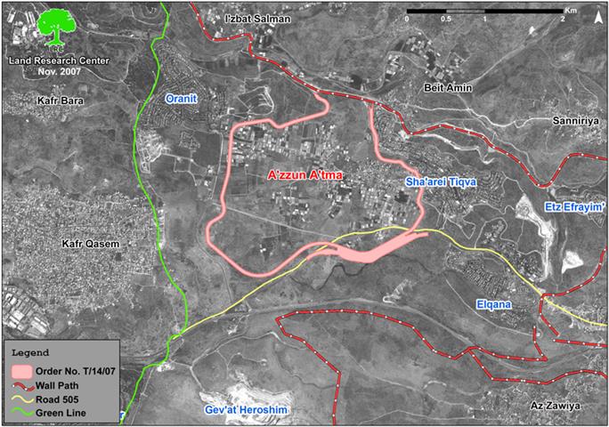
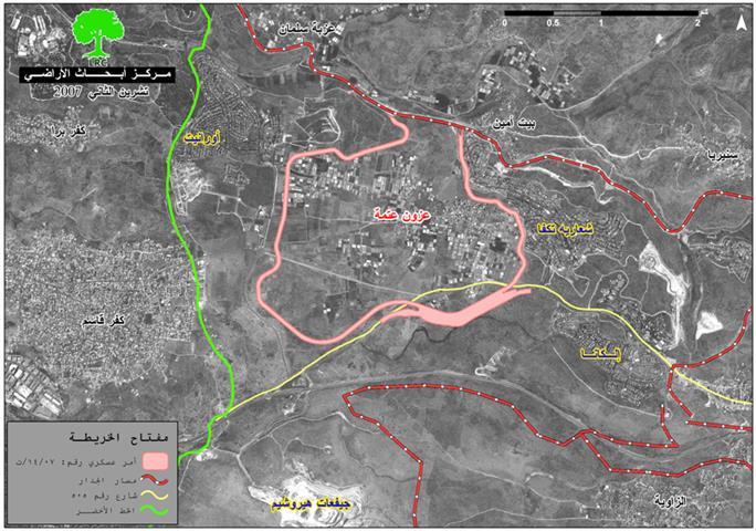
The Israeli occupation army issued a new military order in the second half of last October stating the confiscation of ...
أصدرت جيش الاحتلال الاسرائيلي في النصف الثاني من شهر تشرين أول الماضي أمرا عسكريا يحمل رقم (07/14/T) ينص ...
شكلت قرية دير قديس كمثيلاتها من سائر القرى و المدن الفلسطينية في الضفة الغربية هدفاً للاحتلال الإسرائيلي البشع ...

........................................................

........................................................

........................................................

........................................................

This website and its content were initiated in 1993 by the Applied Research Institute – Jerusalem (ARIJ) and the Land Research Center (LRC) with the support from the European Union up until 2023. Since then, the Applied Research Institute – Jerusalem (ARIJ) has taken over the continued development and maintenance of the website. The views expressed remain solely those of ARIJ) and do not necessarily reflect those of the European Union.