• About The Project
  • Palestine in Century
  • Selected Maps
  • Glossary
  • About ARIJ
  • About LRC
  • By Year
    • Case Studies By Year
    • Daily Report By Year
Wednesday, July 2, 2025
POICA
No Result
View All Result
  • Home
  • Settlements
    • New Israeli Settlements
    • Settlement Expansion
  • Israeli Violations
    • Agriculture
    • Confiscation
    • Demolition
    • Environment
    • Eviction of Palestinians
    • Settlers Attacks
  • Bypass Roads
  • Israeli Plans
  • Segregation
    • Checkpoints
    • Closure
    • Separation Plans
  • Military Orders
  • Reports
    • Daily Report
    • Monthly Report
    • Quarterly Report
No Result
View All Result
POICA
No Result
View All Result

Otniel settlement Expanding At The Expense Of Yatta village

July 20, 2000
in Settlement Expansion
Otniel settlement Expanding At The Expense Of Yatta village


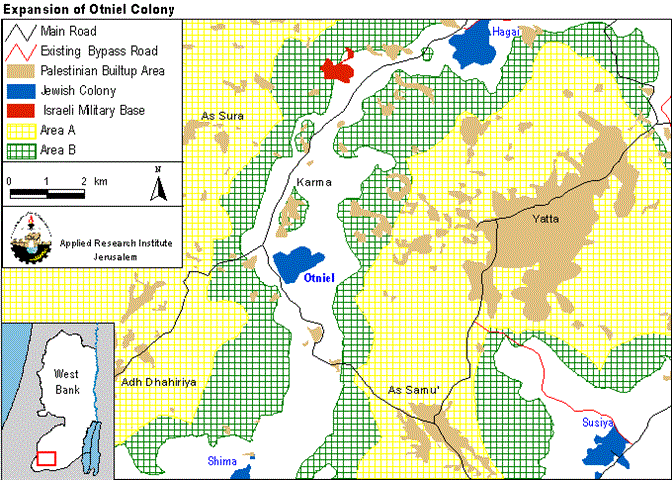
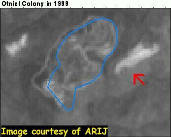
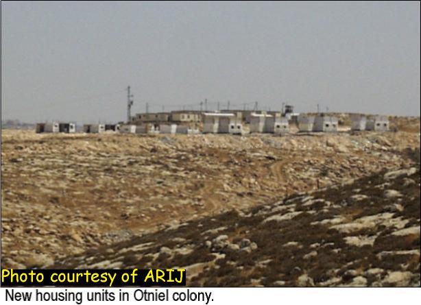
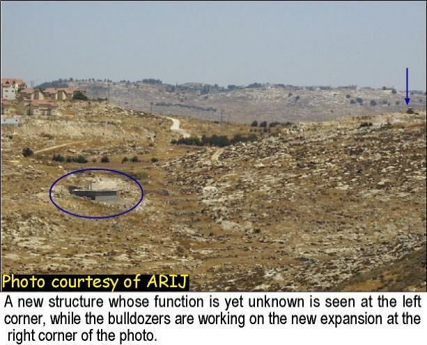
The settlement of Otniel was established in 1983 when Likud was in power under Prime Minister Yitzhak Shamir. It is situated on a mountaintop some 3 kilometers west of the town of Yatta in southern part of Hebron district (see map). The area around Otniel is used by the Yatta villagers for rain fed farming. The direct surroundings of the settlement are designated as a closed military area. When one looks at the settlement one sees two parts, one civilian and one military. The military part has recently been expanded and there are signs that it will be transformed into a civilian area. If this turns out to be true it is another example of the misleading character of the term closed military area. Satellite images from 1996 and 1999 show a clear difference in the eastern part of the settlement. While the 1996 image shows only a small block of caravans, the 1999 images reveal part of the land being leveled (see images 1&2). Pictures taken by the ARIJ fieldworkers in July 2000 show housing construction on this side (see photo).).


Looking at the mountain one notices the dry surroundings and Bedouin livelihoods in the valley. On top of the hill, on the western corner of the settlement, a religious education center towers over the land. East of it lies the urban section, with a swimming pool for recreation purposes and waste water tanks halfway down the hill. Below it a new building is constructed, for what purpose is not clear. (see photos 1&2)


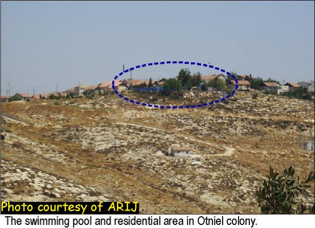
For the villagers of Yatta this settlement must be a hard fact of life, not only because of Israeli presence just around the corner but for a few other reasons as well. First, there is a huge water shortage all over the West Bank, but especially in the Hebron district. It is estimated that the experienced shortage is three times the amount of water supplied by the Israeli water company, Mekorot, the monopolist on water in the West Bank as well as in Israel proper. Israeli settlements on the West Bank are supplied with sufficient water during the entire year, even an increase in the summer. For example, the average annual water consumption per capita in a settlement is between 650 and 1,714 CM in contrast to 107 to 156 CM in Palestinian areas. To see a swimming pool here, above the dry land must be a bitter experience for a Palestinian. Second, the land used by villagers for rain-fed farming suffers from pollution caused among others by sewage and wastewater from Israeli settlements. The two big water tanks halfway the hill are no indication that this settlement will be an exception.

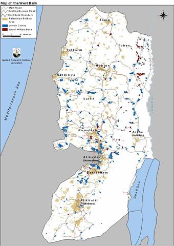
Why is this settlement expanding, situated in an isolated position in the middle of Hebron district? However illegal all the settlements in the West Bank are (as international agreements clearly show) in most cases one can see strategic significance of the location. For example, settlements close to the 1949 Armistice Line are part of realizing the Allon plan, while settlements around Jerusalem are part of the project to establish a greater Jerusalem. Other settlements on isolated locations in the West Bank are also of strategic importance. They are to prevent or disrupt, with the network of bypass roads, the unity of the West Bank. In the case of Otniel, it separates two big blocks of area A in Hebron district (see map). Another reason for the existence of this settlement is shown by its biggest and probably most expensive building: the religious education center (see photo). But why do they want to expand it at such a delicate moment in time when the Palestinian and Israeli leaders are talking about peace? Maybe they want to grab all the land possible before an agreement is reached. Maybe one can find an answer on Otniel website www.internadlan.com/amana/otniel/index.htm .To get a clear answer on the ''why?'' question one should probably contact the Yesha council (the organization that manages the settlements in the West Bank and Gaza,  www.yesha.org), but the reason they will give you will never correspond with the international and bilateral agreements signed.


Prepared by:
The Applied Research Institute – Jerusalem

Recommended For You

Expansion of Gilo Settlement: A Strategic Plan to Isolate Bethlehem and Undermine Palestinian Rights

by arij
May 12, 2025
0
Expansion of Gilo Settlement: A Strategic Plan to Isolate Bethlehem and Undermine Palestinian Rights

The Israeli Civil Administration has announced a new settlement expansion plan—No. 101-1284223—which outlines the construction of 1,990 new settlement units on approximately 175.9 dunums of land extending towards...

Read moreDetails

إسرائيل تمضي قدمًا في مخطط استيطاني جديد على أراضي مدينة بيت جالا، في انتهاك للقانون الدولي وحرمان الفلسطينيين من أراضيهم

by arij
April 29, 2025
0
Israel Advances Settlement Plan on Ancient Olive Groves on lands of Beit Jala city, Violating International Law and depriving Palestinians their lands

  في أواخر شهر شباط من العام 2025، صادقت دولة الاحتلال الإسرائيلي على مخطط استيطاني جديدة لبناء حي سكني للمستوطنين على مساحة 22.2 دونما من الأراضي الفلسطينية لتابعة...

Read moreDetails

سلطات الاحتلال الإسرائيلي تصادر 64 دونما شمال مدينة بيت لحم لإقامة موقفا للحافلات

by arij
October 19, 2023
0
سلطات الاحتلال الإسرائيلي تصادر 64 دونما شمال مدينة بيت لحم لإقامة موقفا للحافلات

  في السابع من شهر أيلول من العام 2023, صادقت بلدية الاحتلال الإسرائيلي في القدس المحتلة على مخطط استيطاني جديد من شأنه أن يصادر مساحات شاسعة من أراضي...

Read moreDetails

Israeli Settlements in the Occupied West Bank: from “outposts” to urban blocks

by arij
May 20, 2023
0
Israeli Settlements in the Occupied West Bank: from “outposts” to urban blocks

  The Applied Research Institute – Jerusalem (ARIJ) In cooperation with Palestine Economic Policy Research Institute (MAS)   Preface Legalizing nine Israeli settlement outposts in the occupied West...

Read moreDetails

استكمال انشاء حي استعماري تابع لمستعمرة ” الكانا” على أراضي قرية مسحة / محافظة سلفيت

by arij
November 1, 2022
0
استكمال انشاء حي استعماري تابع لمستعمرة ” الكانا” على أراضي قرية مسحة / محافظة سلفيت

  الانتهاك: توسع استيطاني. الموقع: قرية مسحة / محافظة سلفيت. تاريخ الانتهاك: تشرين أول 2022. الجهة المعتدية: مستعمرة " الكانا". الجهة المتضررة: أهالي قرية مسحة.  تفاضيل الانتهاك:   استكمل...

Read moreDetails
Next Post
The Second Intermediary Report for the “Monitoring Israeli Colonizing Activities” Project

The Second Intermediary Report for the "Monitoring Israeli Colonizing Activities" Project

LATEST NEWS

أمر عسكري إسرائيلي يستهدف أراضي قرية زبوبا الفلسطينية لأغراض أمنية مستعجلة

Israeli Order Targets Zububa Village Under Security Claims

by arij
June 24, 2025
0

........................................................

أمر عسكري إسرائيلي يستهدف أراضي قرية زبوبا الفلسطينية لأغراض أمنية مستعجلة

أمر عسكري إسرائيلي يستهدف أراضي قرية زبوبا الفلسطينية لأغراض أمنية مستعجلة

by arij
June 21, 2025
0

........................................................

At the Southeast Bethlehem Governorate: Al-Minya and Kisan Villages Caught Between Forced Displacement and Israel’s Expanding Settlement Plans

At the Southeast Bethlehem Governorate: Al-Minya and Kisan Villages Caught Between Forced Displacement and Israel’s Expanding Settlement Plans

by arij
June 21, 2025
0

........................................................

جنوب شرق بيت لحم: قرى المنيا وكيسان بين مطرقة التهجير وسندان مخطط التوسع الاستيطاني الإسرائيلي

جنوب شرق بيت لحم: قرى المنيا وكيسان بين مطرقة التهجير وسندان مخطط التوسع الاستيطاني الإسرائيلي

by arij
June 21, 2025
0

........................................................

flag_yellow_lowEU-PfP-Logo

This website has been produced with the assistance of the European Union. The contents of this publication are the sole responsibility of ARIJ & LRC and can in no way be taken to reflect the views of the European Union.

© 2025 Copyright ARIJ . All Rights reserved. .

No Result
View All Result
  • Home
  • Settlements
    • New Israeli Settlements
    • Settlement Expansion
  • Israeli Violations
    • Agriculture
    • Confiscation
    • Demolition
    • Environment
    • Eviction of Palestinians
    • Settlers Attacks
  • Bypass Roads
  • Israeli Plans
  • Segregation
    • Checkpoints
    • Closure
    • Separation Plans
  • Military Orders
  • Reports
    • Daily Report
    • Monthly Report
    • Quarterly Report

© 2025 Copyright ARIJ . All Rights reserved. .