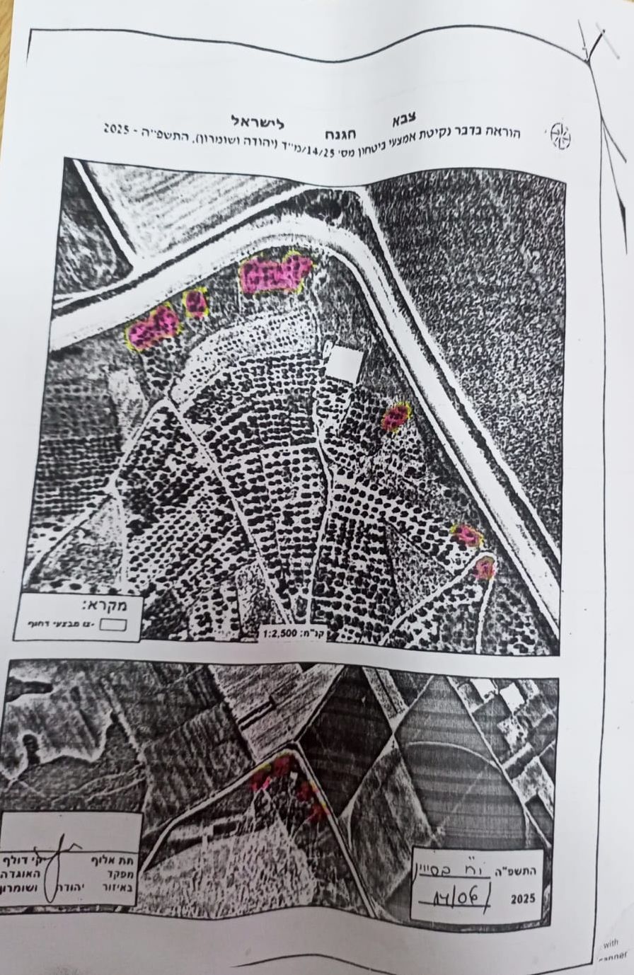
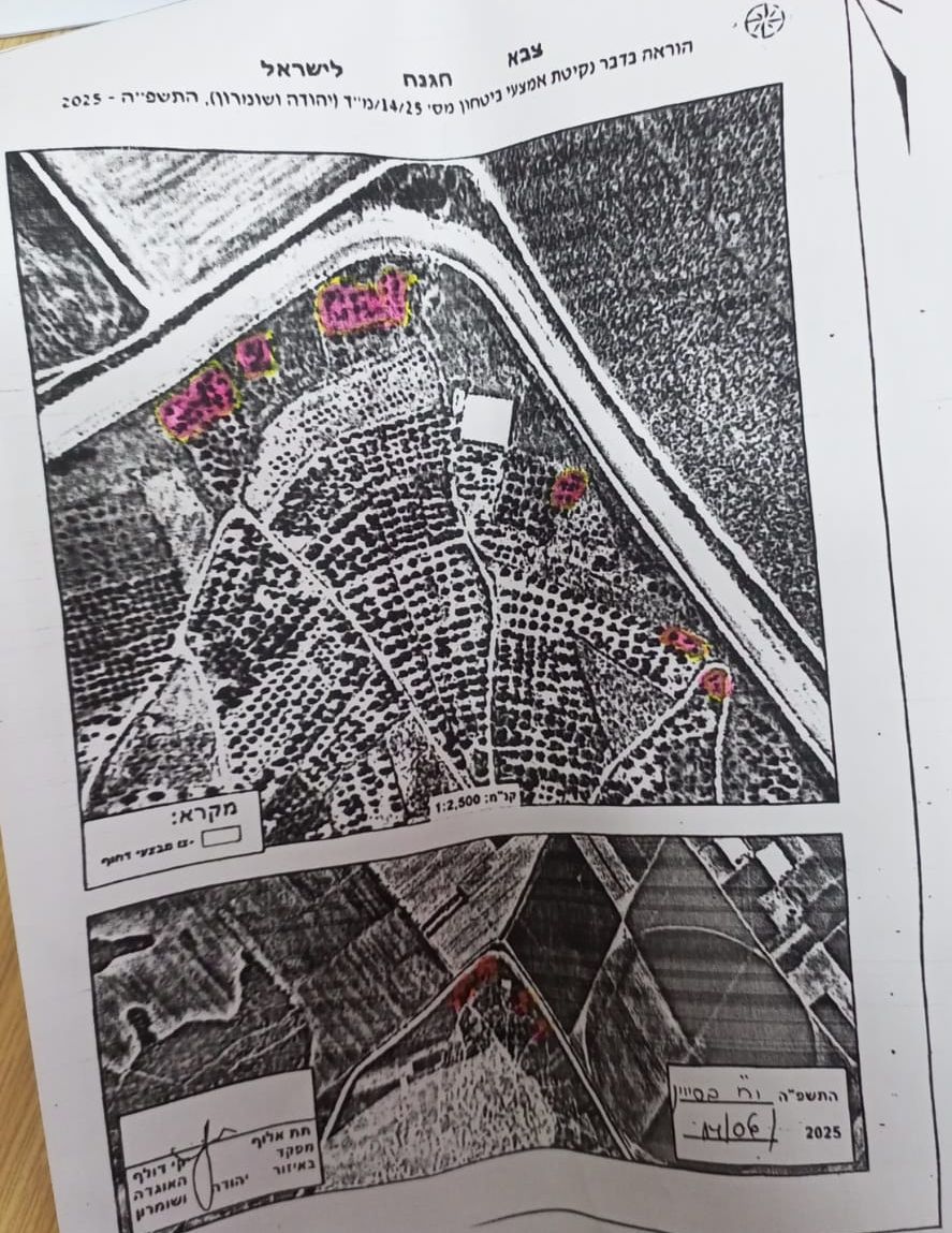
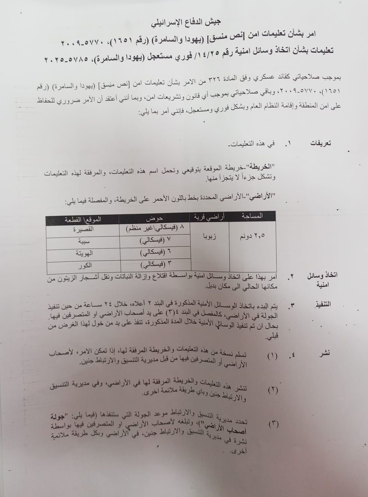
As part of Israel’s systematic violations against Palestinian land in the occupied West Bank”, the Israeli occupation authorities, on June 14, 2025, issued a new military order to Land owners of Zububa village, located west of Jenin. The order mandates the confiscation of 2.5 dunums of privately owned agricultural land under the pretext of ‘urgent security needs.’ The targeted plots fall within land parcels 3, 6, 7, and 8 in the village of Zububa, specifically in the area adjacent to the route of the illegal Separation Wall. The military order stated the following:”
| Israel Defense Forces
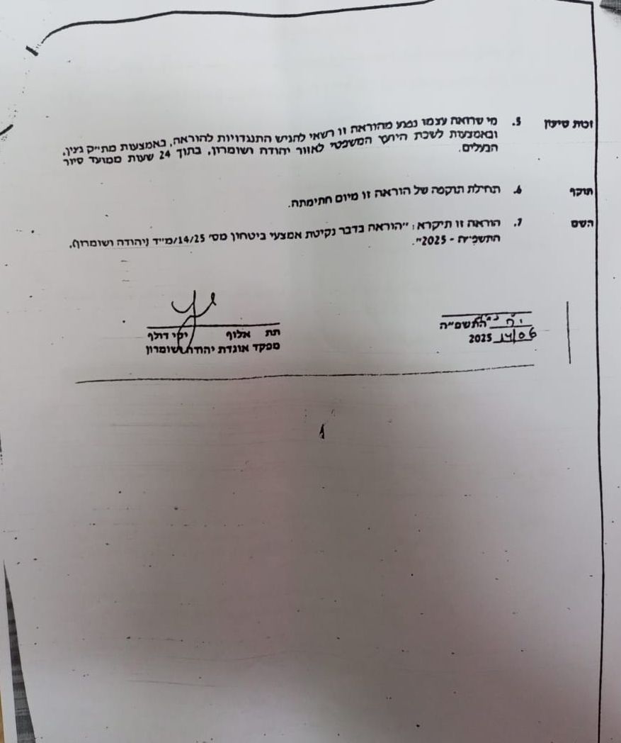
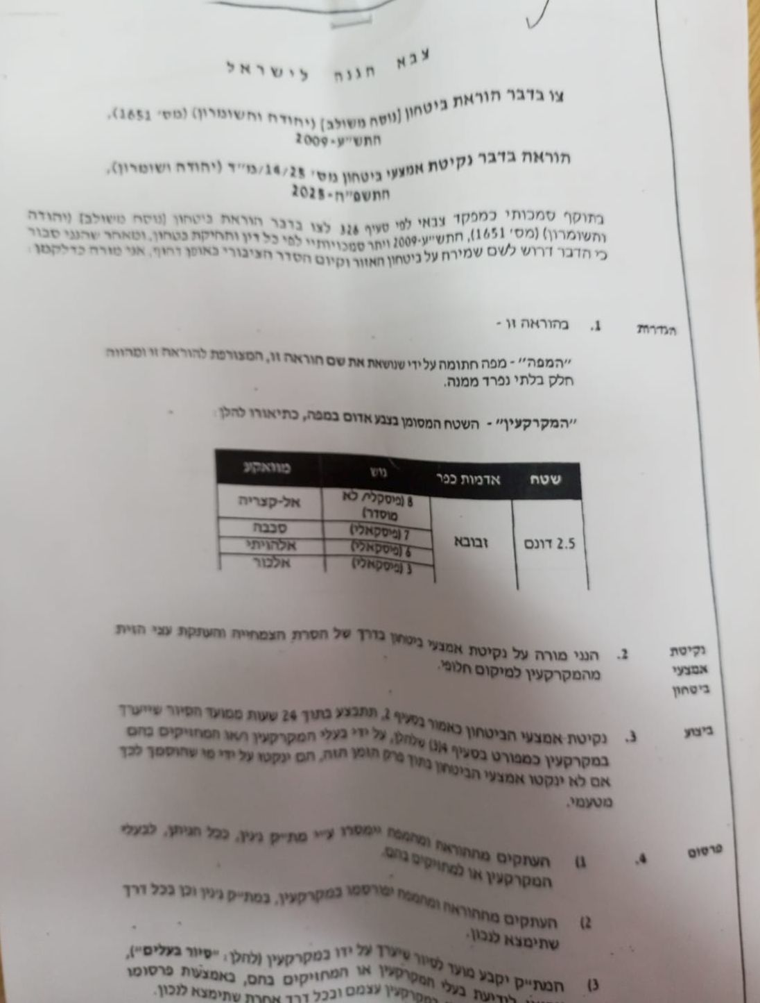
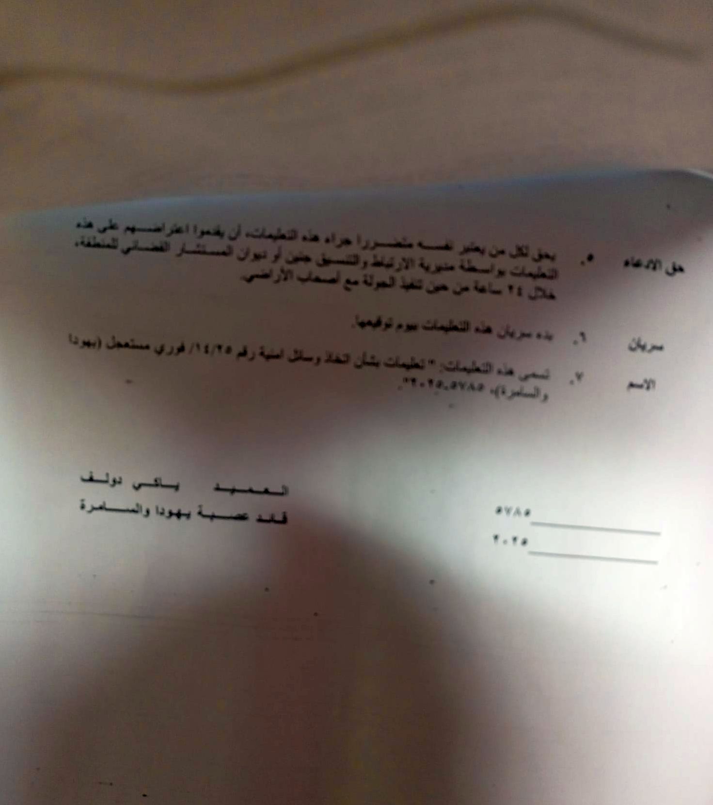
Order Regarding Security Provisions (Consolidated Version – Judea and Samaria) (No. 1651), 5770–2009 Instructions on the Adoption of Security Measures – Order No. 14/25 – Immediate and Urgent – Judea and Samaria, 5785–2025 Pursuant to my authority as the Military Commander under Article 326 of the Order Regarding Security Provisions (Consolidated Version – Judea and Samaria) (No. 1651), 5770–2009, and by virtue of all other powers vested in me by any law or security legislation, and as I believe that this order is necessary for maintaining the security of the area and the preservation of public order, in an immediate and urgent manner, I hereby order the following: |
The Land” – the area marked with a red line on the attached map and detailed as follows:
| Area | Village Name | Parcel | Location |
| 2.5
dunums |
Zabuba | 8 | Al Qaseira |
| 7 | Sababa | ||
| 6 | Al Huwaita | ||
| 3 | Al Kour |
 |
 |
 |
 |
 |
ن
The Israeli order, imposed on the villagers without prior notice, stipulates the uprooting of dozens of ancient olive trees on the confiscated land (which amounts to 2.5 dunums), and declares the area a “closed military zone” for urgent security purposes. This effectively prohibits Palestinian landowners from entering or working on their land, thereby depriving them of their direct source of livelihood. According to the military order received by the affected landowners, the decision takes effect on June 14, 2025, and grants the Israeli army the authority to carry out the measures at any time, under the pretext of “security necessities.”
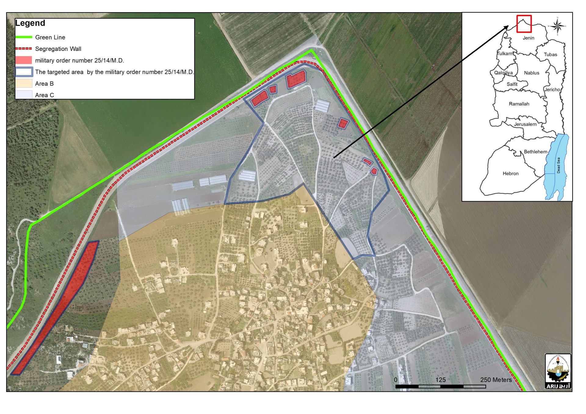 The targeted basins, according to the order, are located in a strategic area of the village, raising concerns among Palestinians that the plots designated in the military order may later be transformed into permanent military observation points—especially since they lie adjacent to the Israeli separation wall. There are fears that Israeli occupation authorities may, in the future, prevent villagers from accessing the entire mountain, which is planted with hundreds of olive trees that serve as a vital source of livelihood for many Palestinian families in the area. It is worth noting that the targeted lands lie in an area still classified as ‘Area C’ under the 1995 Oslo II Interim Agreement, which places the area under full Israeli control.”
Zububa village in the Shadow of the Israeli Occupation
Zububa is one of the Palestinian villages in the occupied West Bank that has endured repeated violations over the past years, primarily due to its proximity to the Israeli separation wall. Construction of the wall on lands of the village began in June 2002. The Israeli occupation authorities claimed that the wall is being constructed along “the 1949 Armistice Line (Green Line)”. However, according to subsequent Israeli-issued maps, the route of the separation wall extends deep into the heart of the West Bank, effectively annexing as many Israeli settlements, outposts, natural resources, and vast areas of land as possible—amounting to approximately 13% of the West Bank’s total area (once construction of the wall is completed). This reflects the Israeli systematic policy to unilaterally redraw the boundaries of the West Bank and impose separation on the ground.
The initial phase of wall began in the northern part of the occupied West Bank, from the Palestinian village of Zububa and extending downward to Salem Israeli checkpoint, (known today as Salem military base and Detention center). Israeli bulldozers began clearing the land to construct the first section of the separation wall—designed as a fence in the village of Zububa, where the village lost hundreds of dunums of its land for that purpose and lands were closed off to implement the Israeli separation plan.
About Zububa Village
The Palestinian village of Zububa covers an area of 2,630 dunums. According to the 1995 Oslo II Interim Agreement, the lands of Zububa were classified into Areas B and C. An area of 1,676 dunums (65% of the village’s total land) was designated as Area B, where the Palestinian Authority has full civil control, while the Israeli occupation retains full security control. The remaining 954 dunums (35% of the total village area) were classified as Area C, which is under the full control of the Israeli government. In Area C, Palestinian construction or land use is prohibited without a permit issued by the Israeli Civil Administration. Area C includes agricultural lands, open spaces, and small parts of the built-up area.
| Table 1: Land Classification of the Village of Zububa – Jenin, according to the 1995 Oslo II Interm Agreement | ||
| Land Classification | Area (Dunum) | % of the total village area |
| Area A | —– | —— |
| Area B | 1676 | 65 |
| Area C | 954 | 35 |
| Nature Reserve | 0 | —– |
| 100 | 2630 | Total |
SOURCE: APPLIED RESEARCH INSTITUTE – JERUSALEM (ARIJ)
Conclusion
The Israeli occupation authorities frequently invoke “security” as a pretext to impose military orders on Palestinian lands, despite the fact that international law prohibits the seizure of occupied land for purposes unrelated to immediate and temporary military necessity.
According to Article 52 of the Fourth Geneva Convention of 1949, the occupying power may only requisition private or public property if it is strictly required for immediate and temporary military operations—conditions that do not apply to permanent confiscations or those carried out for settlement expansion.
Israeli security claims are often used to justify the expansion of existing settlements, the establishment of new ones, the construction of outposts, and the building of the separation wall—all practices deemed contrary to international law by the International Court of Justice in its 2004 advisory opinion. These measures alter the geography and demography of the occupied territories.
The Israeli use of military orders constitutes a systematic policy aimed at land control and the imposition of new realities on the ground—an act in clear violation of the United Nations Charter, particularly Article 2, which prohibits the use of force or the threat thereof to acquire territory. It also violates the rights of the occupied population to legal protection and to live in dignity on their land.
Prepared by:
The Applied Research Institute – Jerusalem

.


