Introduction
The Ma'ale Adumim settlement bloc is the largest settlement bloc established in the Occupied Palestinian Territory with a population of around 33,000 settlers and occupies more than 22,000 dunums (22 km²) of confiscated Palestinian lands from Abu Dis, Ezariya, Isawiya, At Tur, and 'Anata towns.
With Israel's decision to construct the Segregation wall in the West Bank, the Ma'ale Adumim bloc has gained the attention of the Israeli Government due to its location inside the Jerusalem Governorate boundaries and its closeness to the eastern part of Jerusalem city. A new addition to the Ma'ale Adumim settlement block has started to take place in the confiscated Palestinian lands between east Jerusalem and Ma'ale Adumim settlement, the expansion is called the E1 plan and aims at hampering East Jerusalem Palestinian localities from expanding the built-up areas of their towns and villages, at the same time, ensuring a Jewish majority in the area through the addition of 3500 new housing units to the northwest of the Settlement, and creating a corporal link between the bloc itself and Israeli settlements in Jerusalem (the French Hill, Pisgat Amir, Pisgat Ze'ev and Neve Yaacov). The 'E1', once fully implemented, will increase the area of the settlement by more than 50% and will block the geographical contiguity between the northern and southern parts of the West Bank.
The Segregation Wall around Ma'ale Adumim settlement Bloc
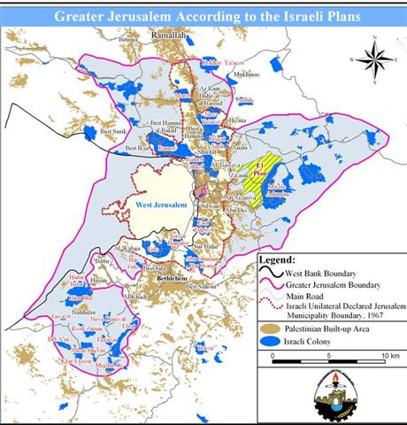
The Segregation Wall around Ma'ale Adumim settlement bloc is part of the wall that encircles Jerusalem, the so called 'Jerusalem Envelope' which is going to stretch for 190 km around the city of Jerusalem, extending from the settlement of Har Adar, to encompass the Giv'at Ze'ev settlement bloc, the Ma'ale Adumim settlement bloc, and stretch toward the south of the West Bank to encompass the Gosh Etzion settlement bloc. The route of the wall resembles the 'Greater Jerusalem' plan, see map 1 of Greater Jerusalem. ' plan,

Map 1: Greater Jerusalem
New Military orders for the Segregation Wall Path around Ma'ale Adumim settlement Bloc
The Israeli Occupation Forces Issued on August 15, 2005 four military orders to confiscate lands from Abu Dis, Ezariyeh, As Sawahreh Ash Sharqiyeh in Jerusalem District. The military orders numbered ( At Tur (T/05/150), Al Ezariyeh (T/05/151), Abu Dis (T/05/152), As Sawahreh (T/05/153)) stated the confiscation of a total of 1585 dunums; of which 809 dunums from Abu Dis city, 477 dunums from the lands of Al Ezariyeh city, 87 dunums in At Tur Area and 212 dunums of As Sawahreh Ash Sharqiyeh town for military purposes, mainly to construct the Segregation Wall around Ma'ale Adumim settlement bloc (Ma'ale Adumim, Mishor Adumim industrial zone, Kfar Adumim, and Alon) already established on 11.5 km² (11500 dunums) of lands previously confiscated from those three towns following the 1967 war. See Map 2
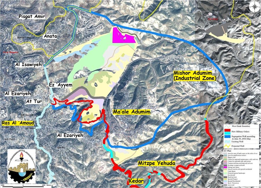
Map 2: Map of military orders
Update on Wall Path around Ma'ale Adumim settlement Bloc.
As for fending off national and International pressure and the ICJ decision on July 19, 2004 that called for an immediate halt of wall constructions and dismantling of existed sections, Israel updated the Segregation Wall path in the West Bank to include changes in southern and central areas of the West Bank. In the same time, the new wall path published on the Israeli defense ministry's website on February 2005, mainly around Ma'ale Adumim settlement bloc, increased by 40% than the one published in June 2004 where the wall length became 46 km instead of 33 km (according to June 2004 map). The Wall will also segregate about 62 km² of land, an increase of 59% than the area that was about to become segregated by the wall according to June 2004 Map.
Today, the Ma'ale Adumim settlement bloc occupies 1% of the total West Bank area and includes 8 settlements, Ma'ale Adumim, Mishor Adumim, Mitzpe Yehuda, Kfar Adumim, Kedar, Alon, Neve Brat and Almon known also as 'Anatot. And while Palestinians are still filing suits to the Israeli Supreme court against the construction of the Segregation Wall around Jerusalem city or what is known as the 'Jerusalem Envelope', the Israeli Occupation Forces surprised residents of the aforementioned towns by the military orders that stated the confiscation of 1585 dunums as a warning sign to start constructing the wall in the area. ', the Israeli Occupation Forces surprised residents of the aforementioned towns by the military orders that stated the confiscation of 1585 dunums as a warning sign to start constructing the wall in the area.
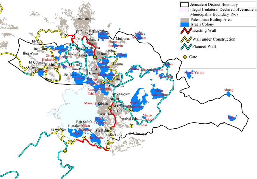
Map 2: Jerusalem Envelope
Changing of Numbers!!!
A thorough analysis conducted by the Geographical Information system at the Applied Research Institute – Jerusalem (ARIJ) showed that the four military orders that were distributed to Palestinian residents living in the areas around Ma'ale Adumim settlement bloc will confiscate a total of 1800 dunums of Palestinian lands, an increase of 215 dunums than the area mentioned in the military orders. This confusion of numbers is part of Israel's policy to mislead Palestinians regarding what is really taking place on the ground. See Map 2
Sharon Intensifies settlement activities in the West Bank in return of disengaging from Gaza …
In an article issued by Haaretz daily newspapers on July 11, 2005 showed that the Israeli Government gave the green light for resuming wall constructions around Jerusalem city. The Government's decision will affect around 100,000 Palestinians living in and around Jerusalem and hold Jerusalem ID cards. In addition to the affected Palestinian communities such as Shu'fat, 'Anata, Hizma, Abu Dis, As Sawahreh Ash Sharqiyeh, Al Ezariyeh, At Tur, and Isawiyeh will be excluded from the illegally Israeli declared Jerusalem municipal boundary upon the completion of the wall around Jerusalem or what is known by the 'Jerusalem Envelope' plan, which will pave the way for an illegal redefinition of Jerusalem municipal boundary.
The decision came on action when the Israel occupation Forces and the Civil Administration issued land confiscation orders late this week in the aforementioned Palestinians towns to construct the Segregation Wall around Ma'ale Adumim settlement bloc. Resuming wall constructions around Ma'ale Adumim settlement bloc intends to create a geographical connection between the Ma'ale Adumim bloc and the settlements situated inside the city of Jerusalem. Prime Minister Ariel Sharon had stated earlier in August that this territorial connection, which is about to take place, is not part of the E-1 plan, which calls for building a new Jewish neighborhood of some 3,500 new housing units west of Ma'ale Adumim settlement (between Ma'ale Adumim and the Palestinian communities east of Jerusalem city: 'There will be a territorial connection in the future, but we don't sanctify the E-1 plan,' said one. 'In any event, it will be years before this plan is approved, so the question is academic.' Source: Analysis / A connection, but nothing more yet. Haaretz Newspaper, August 2005. . Haaretz Newspaper, August 2005.
Although Sharon spoke about years before the E1 plan to come into action, he orders to accelerate the construction of E1 police headquarter, in the area between Jerusalem and Ma'ale Adumim settlement, a step at the beginning of accomplishing the E1 plan. The headquarter is currently located in Ras Al 'Amoud area in East Jerusalem. Haaretz, August 26,2005.
According to Prime Minister Ariel Sharon statement, the E1 plan will not affect the Palestinian communities located in the vicinity of the Settlement bloc, but only a way to link the bloc with the settlements inside Jerusalem city: 'this will not cause the cutting-off of Judea and Samaria. Solutions can be found.' Source: Haaretz August 22, 2005.
Same time, the Israeli prime minister signaled the building and expansion at West Bank settlement blocs to continue: 'There will be building in the settlement blocs,' he said. 'Each government since 1967 has seen strategic importance in specific areas [beyond the Green Line]. I will build'. 'Ma'ale Adumim will continue to grow and be connected to Jerusalem,' and that Ariel and its satellites would be a part of Israel forever. Source: Haaretz August 22, 2005..
The Israeli expansions will come on thousands of dunums of Palestinian lands located in the vicinity of the settlement Bloc. Although the Prime Minister's statements didn't directly indicate the danger that awaits the East Jerusalem communities, but what is happening on the ground, as seen on the satellite images of March 2005 provided by the Applied Research Institute – Jerusalem, is that Israel already started razing lands in the area located west of Ma'ale Adumim settlement. Satellite images showed a clear view of the razing process that took place during the last four months, an evidence which Israel can't deny despite Sharon's statements.
Prepared by:
The Applied Research Institute – Jerusalem


