Husan, a rural Palestinian village (population: 5300) located about 7 Km west of Bethlehem district and recently was forcefully enlisted among the hundreds of other Palestinian villages to intersect the atypical coordinates of what is acknowledged as the most infamous violation of the international law to be recorded yet in the 21st century; the Israeli built/ under-construction Segregation Wall. Even though, the physical structure of the segregation wall (concrete partitions) might vary according to military reasons & topography and substituted with military fence, the latter will still be acknowledged as a 'Segregation Wall' for the metaphoric it represent.
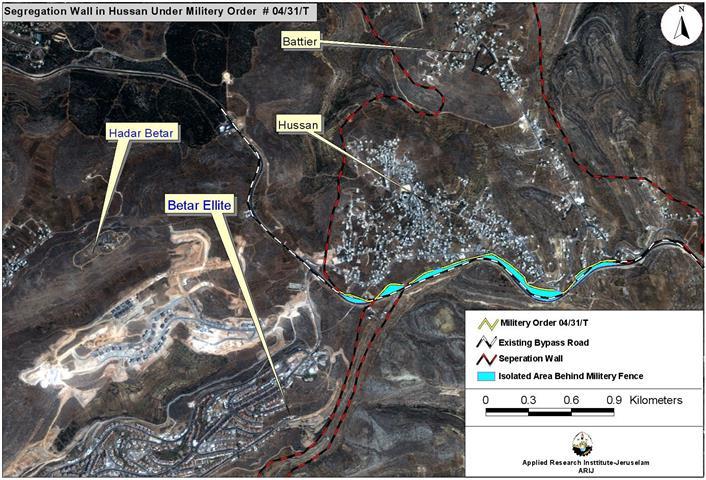
The new orders for the segregation wall come to close-off the enclave where the segregation wall is premeditated to close-in Husan and Battir villages. Military orders were issued on earlier dates indicates the route of the wall which close Husan and Battier villages from the north, east, west & now from the south where the enclave seals in the villages as illustrated.
On March 27, 2004, the Israeli Army scattered the military order # T/31/04 which indicates the area confiscated and description of exploitation on Husan's land. On March 29, 2004, an Israeli Army Officer toured the route of the wall as described in the military order along with members of Husan's Council members, who expressed their anger and resentment of the military order and its sequences. The following is a translation of the military order issued for the segregation wall in Husan. See military order translation below
|
Military Order Translation Israel Defense Forces
According to my jurisdictions as a Military Chief Commander in the Region of Judea and Samaria, and as I believe that it is imperative for military purposes, I order the following:
ITEMS
1. With regard to: Lands An area of land 2305 meters length & 2 meters width marked in red in the map illustrating Husan's land: viscally bloc 3: Wad Abu Hamrah & Um El-Shuqaf location. Battier: viscally bloc 12: Khalit Abu Harath; registered as personal property – marked in red with map scale of 1: 10.000 signed and attached by myself and regarded as an essential part of this order. An area of land 2305 meters length & 2 meters width marked in red in the map illustrating Husan's land: viscally bloc 3: Wad Abu Hamrah & Um El-Shuqaf location. Battier: viscally bloc 12: Khalit Abu Harath; registered as personal property – marked in red with map scale of 1: 10.000 signed and attached by myself and regarded as an essential part of this order.
Land Seize
2. I declare by that the above-mentioned lands seized for military purposes. I declare by that the above-mentioned lands seized for military purposes.
Possession
3. The Israeli Defense Army declares absolute possession of stated lands and authorizes it to the land officer at the central command headquarters under the Ministry of Defense. The Israeli Defense Army declares absolute possession of stated lands and authorizes it to the land officer at the central command headquarters under the Ministry of Defense.
Issuance
4. Copies of the order at hand are to be delivered to the District Coordination Office (DCO) in Bethlehem who will in its turn pass the order on to the landowners. Copies of the order at hand are to be delivered to the District Coordination Office (DCO) in Bethlehem who will in its turn pass the order on to the landowners.
Allocation
To File an Objection
6. land owner are entitled to file an objection regarding the seizure order to the legal counselor throughthe District Coordination Office (DCO) in Bethlehem within 7 days of the tour (5 (A)-2). land owner are entitled to file an objection regarding the seizure order to the legal counselor throughthe District Coordination Office (DCO) in Bethlehem within 7 days of the tour
Compensation Inquiries
7. For inquiries regarding compensations, the landowners are to contact the District Coordination Office (DCO) in Bethlehem. For inquiries regarding compensations, the landowners are to contact the District Coordination Office (DCO) in Bethlehem.
Order Effect
8. The order will go in effect at the time of its signing to June 1, 2004. The order will go in effect at the time of its signing to June 1, 2004.
Identify
9. The order at hand will be identified as ''Land Seize Order # 04/31/T (Judea and Samaria) 2004-5764''. The order at hand will be identified as ''Land Seize Order # 04/31/T (Judea and Samaria) 2004-5764''.
Mosheh Kaplenski |
The new military order for the segregation wall in Husan will cross path with at least four Palestinian houses and one house that will act, as a link or as a part of the wall. Furthermore, the wall will consume nearly five Dunums of land and uproots dozens of fruitful trees along the route it takes. The segregation wall will detach approximately 84 Dunums set for expanding the built-up area in the Husan village where those lands will be no longer viable to utilize in any way. See map of the Segregation Wall in Husan village.

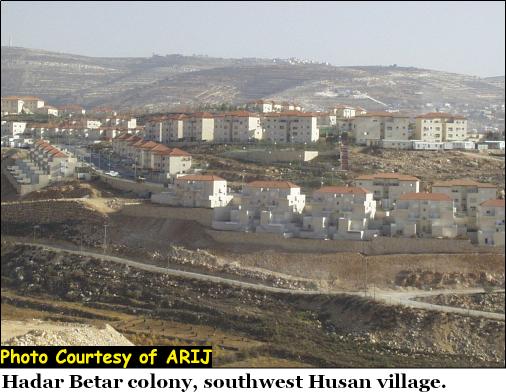
The village of Husan once spread on an area of 7890 Dunums (prior to 1978) was a subject to Israeli greediness on several occasions, which caused the residents of the village to loss of 5620 Dunums of their agricultural land. In 1978, the Israeli settlers under the protection of the Israeli Army seized approximately 2 Dunums south of Husan village to establish the Israeli settlement Hadar Betar. The settlement, which inhabits today 30 – 40 Israeli settlers, forcibly expanded the area of the settlement by 58 Dunums (total 60 Dunums) some years later.
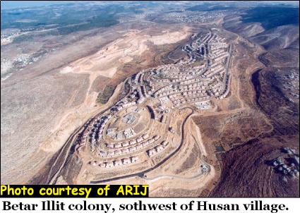
In 1990, a massive operation for the Israeli Army went down few hundred meters south of the Israeli settlement Hadar Betar to build yet another settlement on Husan's land. The new Israeli settlement identified as Betar Ellite spread over 45 Dunums and continue to expand significantly during the 1990's, to take control of 3300 Dunums owned by Husan residents.
Today, the Israeli settlement Betar Ellite inhabited by 20+ thousand Israeli settlers and considered among the largest Israeli settlements in the occupied West Bank territory. The area (1860 Dunums) that falls between the two Israeli settlements: Hadar Betar and Betar Ellite are off-limit to Husan residents, the original owners of the land and considered a part of the settlements' master plan to exploit according to their needs.See Photo of Betar Illit settlement & Hadar Betar
Following the ambiguous Oslo Accord in 1993, the Israeli government began constructing a new bypass road to connect Israeli settlements located south and southwest of the West Bank in the Palestinian districts: Hebron and Bethlehem with Israel. Husan compulsory contribution to the bypass road cost the residents 400+ Dunums of land.
|
Areas Confiscated by Israel from Husan Village over Decades |
||
|
Year |
Purpose |
Area/ Dunums |
|
1978 |
Hadar Betar settlement |
60 |
|
1990 |
Betar Illit settlement |
3300 |
|
—– |
Master Plan Reserved Area |
1860 |
|
1993 |
Bypass Road |
400 |
|
2004 |
Segregation wall |
89 |
|
Total |
|
5,709 |
Husan village, once an agriculturally blooming locality, now, mutated and distorted by strangers to the land, in an explicit violation of the international law and the Geneva accord of 1949. The village residents are living yet a new chapter of torment from the Israeli handbook; now by the segregation wall, which will literally impress the residents and deny them the decent life they deserve.
Related Articles :-
Undermining Peace … Israel's Unilateral Segregation Plans in the Palestinian Territories.
Prepared by:
The Applied Research Institute – Jerusalem