• About The Project
  • Palestine in Century
  • Selected Maps
  • Glossary
  • About ARIJ
  • About LRC
  • By Year
    • Case Studies By Year
    • Daily Report By Year
Sunday, October 26, 2025
POICA
No Result
View All Result
  • Home
  • Settlements
    • New Israeli Settlements
    • Settlement Expansion
  • Israeli Violations
    • Agriculture
    • Confiscation
    • Demolition
    • Environment
    • Eviction of Palestinians
    • Settlers Attacks
  • Bypass Roads
  • Israeli Plans
  • Segregation
    • Checkpoints
    • Closure
    • Separation Plans
  • Military Orders
  • Reports
    • Daily Report
    • Monthly Report
    • Quarterly Report
No Result
View All Result
POICA
No Result
View All Result

Halt of Work Notices for Residential and Agricultural facilities in Kafr Ad-Dik / Salfit governorate

January 11, 2021
in Military Orders
إخطارات بوقف العمل في منشآت سكنية وزراعية في بلدة كفر الديك بمحافظة سلفيت


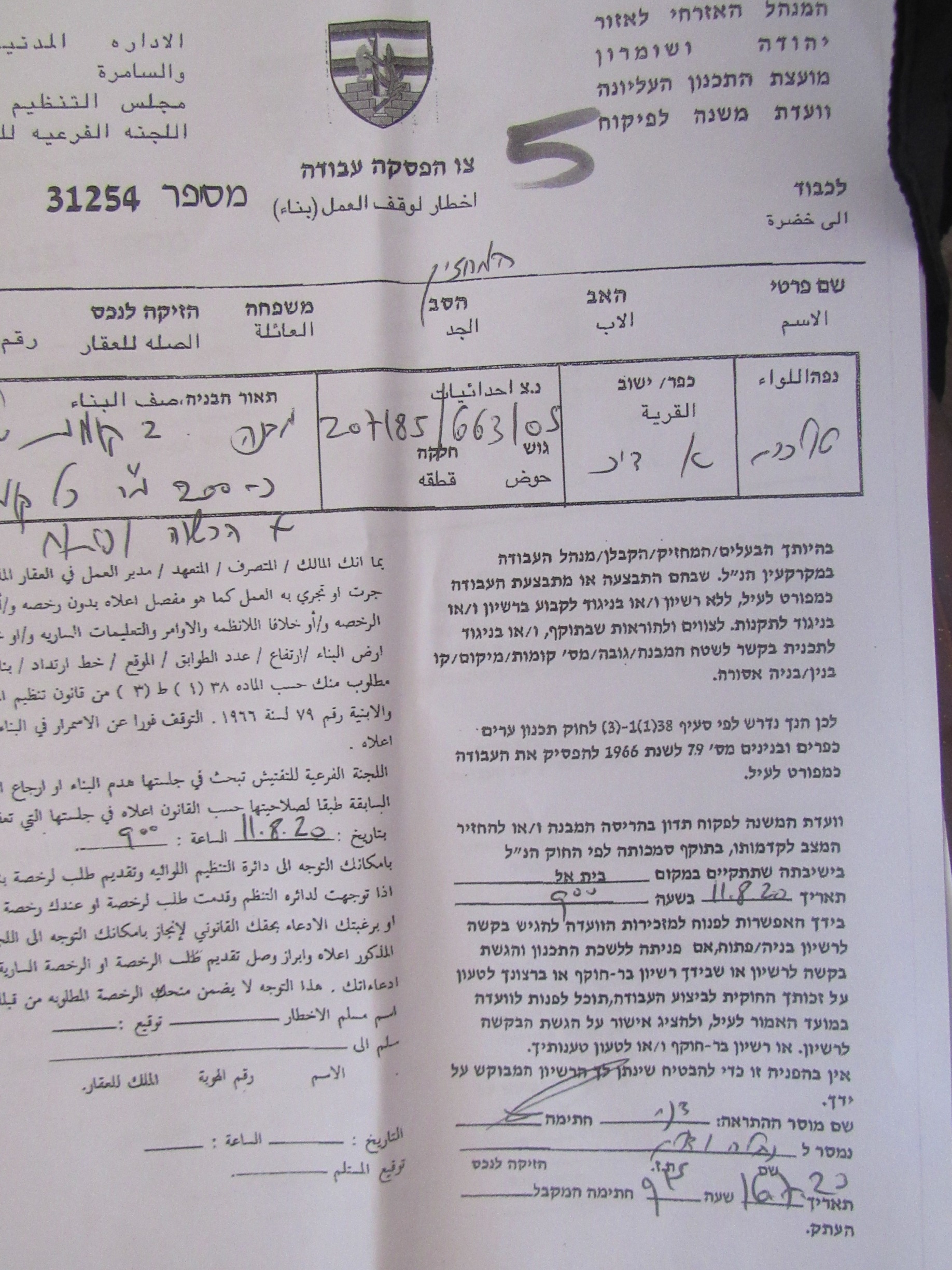
  • Violation: Halt Of Work Notices for Residential and Agricultural facilities.
  • Location: Kafr Ad-Dik / West Salfit.
  • Date: July 16th 2020.
  • Perpetrator: The Building and Organization Department – The Civil Administration.
  • Victims / Affected: A mosque and 14 families at the village.

Description:

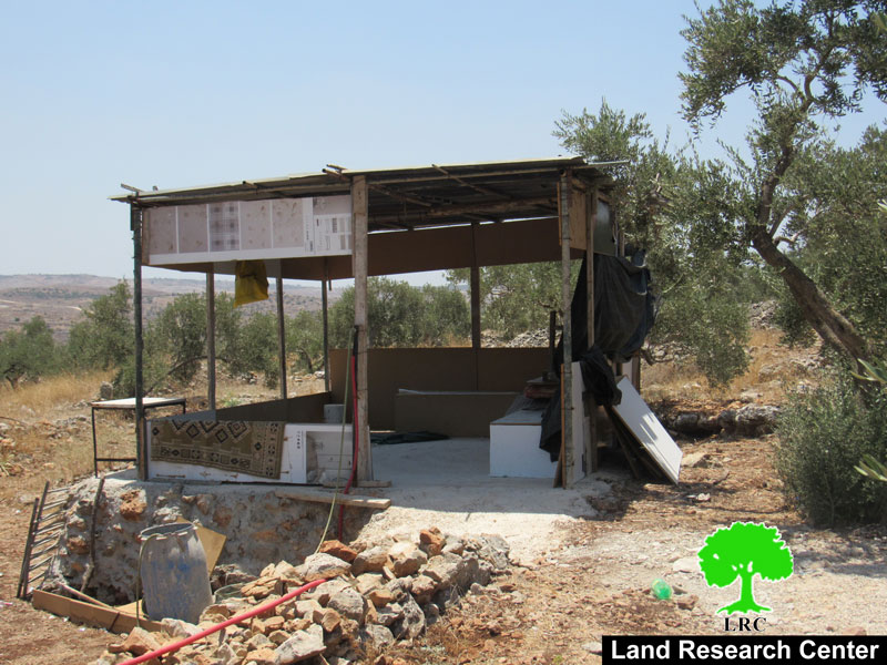
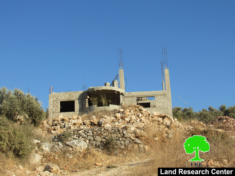
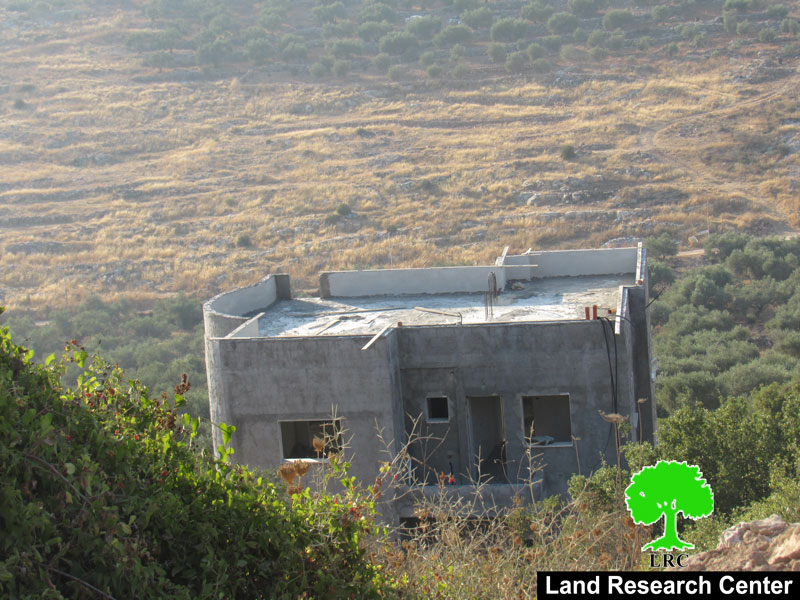
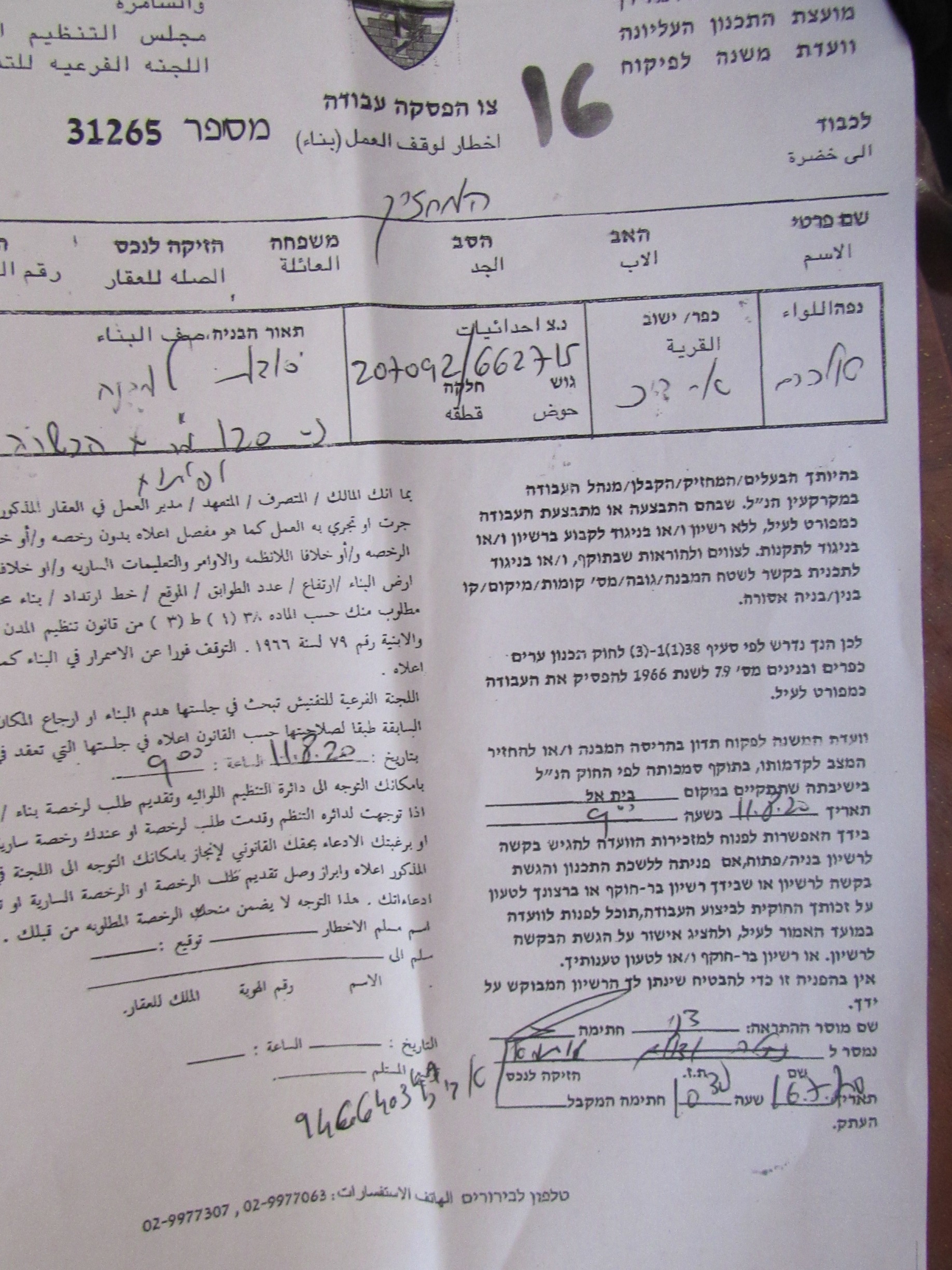
Thursday, July 16th 2020, The Israeli Occupation forces accompanied by the building and organization officer In the Israeli Civil Administration raided Ash-She’ab area to the west of Kafr Ad-Dik , and served halt of work notices on the pretext of building in C area without licenses , the targeted structures are located in an area nearby Peduel settlement cluster and Alei Zahav colony on the town’s lands.

The following table shows more information about the targeted facilities:

Owner

Family members

Notice number

The targeted facility

Photo

Rami ‘Ali Ahmed

8

31251

Under construction house / two floors (320 m2)

1

Younis Ad-Deek

5

31253

Inhabited house / one floor (180 m2)

2

Yaoub Naji

2

31254

One floor house and a Basement (210 m2)

3

Under Construction mosque

–

31256

Under construction house / One floor (200 m2)

4

Othman Ad-Deek

3

31257

Under construction house / One floor 90 m2

5

Mahdi Ad-Deek

6

31258

Under Construction house and a basement (210 m2)

6

Ihab Ad-Deek

3

31042

Inhabited house  two floors (280m2)

7

‘Adnen Ad-Deek

6

N/A

Under Construction house / One floor 180 m2

8

Ahmed Ad-Deek

2

31260

Under Construction house / One floor 210 m2

9

Adam Ad-Deek

2

N/A

Under Construction house / One floor 180 m2

10

Basheer Ad-Deek

7

N/A

Under Construction house / One floor and a ceiling 200 m2

11

Mohammed Naji

2

31263

Stores / under construction 145 m2

12

Rami Naji

8

31264

House / two floors under construction  340m2

13

Hani Naji

5

31265

Agricultural room 60 m2 built of bricks and zinc.

14

Ibrahim Naji

4

31266

Agricultural room built of bricks and zinc 45 m2.

15

total

63


Source: Firsthand field observation, Israeli Violations Monitoring Section – Land Research Center.

Kafr Ad-Deek mayor Mohammed Issa Ad-Deek told LRC the following:

“Al-She’ab area is the only escape for people of Kafr Ad-Deek now that construction is increasing rapidly , as a result of the occupation authorities ban of construction in both northern and western areas of the village , residents have only the middle to build in , this created a rough reality and made life almost impossible in the village.”

Kafr ad Dik:[1]

Kafr ad Dik is located 15 km to the west of Salfit. It is surrounded by Bidya (north), Rafat and Deir Ballut (west), Bruqin and Sarta (east), and Bani Zaid villages (south).

Kafr ad Dik has a population of 5551 people, according to a 2017 census.

Its total area is 15529 dunums; however, it has been suffocated by bypasses and 3 Israeli colonies that lay over its lands.

This has further limited its expansion knowing that it had already had a 791-dunum organizational plan (built-up area); it also isolated the village from its surroundings.

The Israeli occupation confiscated 2477 dunums of Kafr ad Dik lands for the benefit of:

  1. Colonies devoured 1225 dunums, and they are:

Name of colony

Year of construction

Area of confiscated land/ dunum

Number of colonists

Har Eli Zahav

1983.

134.

339.

Eli Zahav- Yoezer

1982.

290.

424.

Bedoel

1984.

800.

1088.

·

1999.

1.

339.

·

1225.

1512.

*Source: Field Research- Monitoring Israeli Violations Team- Land Research Centre (LRC).

  1. Bypasses stole 362 dunums
  2. The Apartheid Wall seized 890 dunums and isolated 8824 dunums and is expected to be 8905 long in Kafr ad Dik lands.

Lands of Kfar ad-Dik are categorized according to Oslo Accords into lands under Area B (15% of the lands) and lands under Area C (85% of the lands).


[1] GIS-LRC


Prepared by

The Land Research Center
LRC

Recommended For You

ما يزيد عن 1900 دونما من الأراضي الفلسطينية في بيت لحم مهددة بالعزل لصالح مستوطنة افراتا

by arij
October 8, 2025
0
ما يزيد عن 1900 دونما من الأراضي الفلسطينية في بيت لحم مهددة بالعزل لصالح مستوطنة افراتا

في الثاني من شهر تشرين أول من العام 2025، أصدرت سلطات الاحتلال الإسرائيلي أمرًا عسكريًا جديدًا يحمل الرقم (ت/3/25) تحت عنوان "تعديل حدود – يهودا والسامرة، 5785-2025". ويأتي...

Read moreDetails

سلطات الاحتلال الإسرائيلي تستغل ‘المنفعة العامة’ لنهب الموارد الفلسطينية

by arij
September 30, 2025
0
سلطات الاحتلال الإسرائيلي تستغل ‘المنفعة العامة’ لنهب الموارد الفلسطينية

في الاول من شهر ايلول من العام 2025، نشرت الإدارة المدنية الإسرائيلية، الذراع الأيمن لحكومة الاحتلال الإسرائيلي أمرا عسكريا جديدا تحت عنوان " أمر ءبشأن قانون الأراضي (الاستملاك...

Read moreDetails

The Occupation Targets the Village of Raba Southeast of Jenin with Military Orders and Seizes Vast Areas of Its Lands

by arij
September 13, 2025
0
الاحتلال يستهدف بأوامر عسكرية قرية رابا جنوب شرق جنين ويصادر مساحات واسعة من أراضيها

 The Israeli occupation Army have continued their policy of plundering Palestinian lands, as their bulldozers leveled wide areas of agricultural land in the village of Raba, southeast of...

Read moreDetails

الاحتلال يستهدف بأوامر عسكرية قرية رابا جنوب شرق جنين ويصادر مساحات واسعة من أراضيها

by arij
September 13, 2025
0
الاحتلال يستهدف بأوامر عسكرية قرية رابا جنوب شرق جنين ويصادر مساحات واسعة من أراضيها

  واصلت قوات الاحتلال الإسرائيلي سياسة نهب الأراضي الفلسطينية، حيث أقدمت آلياتها على تجريف أراض زراعية واسعة في قرية رابا جنوب شرق محافظة جنين، تمهيدا لشق شارع عسكري...

Read moreDetails

Nablus Governorate’s Archaeological Sites Face Israeli Expropriation Plans

by arij
September 11, 2025
0
” المواقع الأثرية في محافظة نابلس… ساحة مفتوحة أمام مخططات المصادرة الإسرائيلية “

On 10 August, 2025, the Israeli Civil Administration (ICA), issued a booklet of military orders signed by the head of the so-called ‘Israeli Civil Administration’ in the occupied...

Read moreDetails
Next Post
Notice of demolition for three agricultural facilities in Rantis village / Ramallah governorate

Notice of demolition for three agricultural facilities in Rantis village / Ramallah governorate

LATEST NEWS

الدورة الشتوية للكنيست الإسرائيلي 2025: الضم كسلاح سياسي وإقليمي

by arij
October 25, 2025
0

........................................................

The Israeli Knesset Winter Session 2025: Annexation as a Political and Territorial Weapon

by arij
October 25, 2025
0

........................................................

Annexation of the Jordan Valley: Implications for the Two-State Solution and Regional Stability

الرئاسة الثانية لترامب: فرصة متجددة لطموحات إسرائيل التوسعية – ضم غور الأردن والتداعيات على حل الدولتين واستقرار المنطقة

by arij
October 14, 2025
0

........................................................

محافظة أريحا على خريطة المصادرة الإسرائيلية- إسرائيل تسعى للاستحواذ على أكثر من 7000 دونم في منطقة النبي موسى

محافظة أريحا على خريطة المصادرة الإسرائيلية- إسرائيل تسعى للاستحواذ على أكثر من 7000 دونم في منطقة النبي موسى

by arij
October 13, 2025
0

........................................................

flag_yellow_lowEU-PfP-Logo

This website and its content were initiated in 1993 by the Applied Research Institute – Jerusalem (ARIJ) and the Land Research Center (LRC) with the support from the European Union up until 2023. Since then, the Applied Research Institute – Jerusalem (ARIJ) has taken over the continued development and maintenance of the website. The views expressed remain solely those of ARIJ) and do not necessarily reflect those of the European Union.

© 2025 Copyright ARIJ . All Rights reserved. .

No Result
View All Result
  • Home
  • Settlements
    • New Israeli Settlements
    • Settlement Expansion
  • Israeli Violations
    • Agriculture
    • Confiscation
    • Demolition
    • Environment
    • Eviction of Palestinians
    • Settlers Attacks
  • Bypass Roads
  • Israeli Plans
  • Segregation
    • Checkpoints
    • Closure
    • Separation Plans
  • Military Orders
  • Reports
    • Daily Report
    • Monthly Report
    • Quarterly Report

© 2025 Copyright ARIJ . All Rights reserved. .