• About The Project
  • Palestine in Century
  • Selected Maps
  • Glossary
  • About ARIJ
  • About LRC
  • By Year
    • Case Studies By Year
    • Daily Report By Year
Friday, March 13, 2026
POICA
No Result
View All Result
  • Home
  • Settlements
    • New Israeli Settlements
    • Settlement Expansion
  • Israeli Violations
    • Agriculture
    • Confiscation
    • Demolition
    • Environment
    • Eviction of Palestinians
    • Settlers Attacks
  • Bypass Roads
  • Israeli Plans
  • Segregation
    • Checkpoints
    • Closure
    • Separation Plans
  • Military Orders
  • Reports
    • Daily Report
    • Monthly Report
    • Quarterly Report
No Result
View All Result
POICA
No Result
View All Result

Israeli Occupation Forces confiscate six agricultural dunums to establish military watchtower in Ramallah

March 26, 2016
in Military Orders
Israeli Occupation Forces confiscate six agricultural dunums to establish military watchtower in Ramallah


  • Violation: confiscation of six dunums
  • Location:  Beitin and Al-Bireh – Ramallah
  • Date:  March 25, 2016
  • Perpetrators: Israeli Occupation Forces
  • Victims:  residents of Beitin village

Details:

Israeli Occupation Forces issued the military order number (16/5/md) to seize 5.942 dunums from the lands of Al-Bireh city. Noteworthy, the targeted lands are private Palestinian ones owned by farmers from Beitin village.

The targeted lands are founded within the natural block number 12; more specifically in the parcels number (81, 86, 87, 89). The lands are located nearby the southern entrance of Beitin village, which leads to Al-Bireh city. This road was re-opened in February 2016.


Photos 1+2: the military order attached with a map of the targeted lands

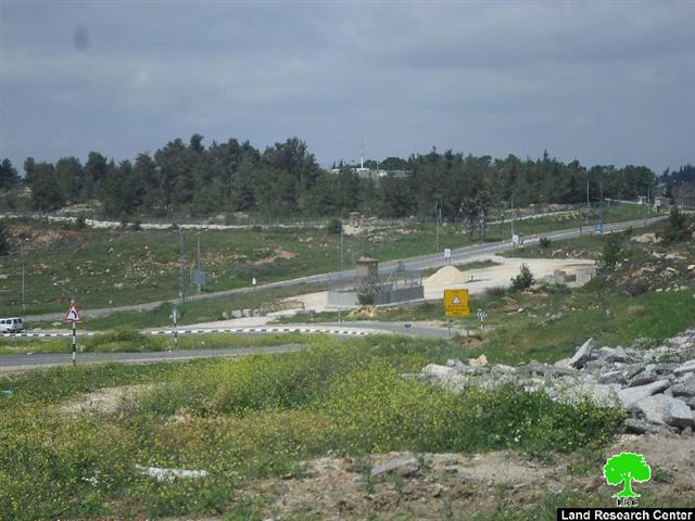
Photo 3: the targeted lands

According to the field research of Land Research Center in the area, the occupation set up a watchtower to impose control on the whole area and monitor the movement and travels of residents. It should be marked that the watchtower monitors a road that is nearby Beit EL colony that is established on confiscated lands from Beitin and the neighboring villages.

About Beitin:

It is located three km to the southeast of Al-Bireh city. The village populates 3200 people (Palestinian Central Bureau of Statistics PCBS-2014). Beitin accommodates three main families namely ( Hamid, Jarab', Zaydan and Khalil).

Beitin totals  5670 dunums in area, of which 508 dunums are the village's built-up area. The Israeli occupation confiscated 160 dunums for the favor of constructing Beit El colony.

Some international laws pertaining lands confiscation:

1.International Covenant on Economic, Social and Cultural Rights stating:

 “All peoples may, for their own ends, freely dispose of their natural wealth and resources without prejudice to any obligations arising out of international economic co-operation, based upon the principle of mutual benefit, and international law. In no case may a people be deprived of its own means of subsistence”.

  1. Article 17 of the (1948) Universal Declaration of Human Rights stating:

“Everyone has the right to own property alone as well as in association with others. No one shall be arbitrarily deprived of his property.”


Prepared by
 The Land Research Center
LRC
 

Recommended For You

سلطات الاحتلال الإسرائيلي تستخدم الأوامر العسكرية لتعمق المشروع الاستيطاني في الضفة الغربية المحتلة

by arij
February 26, 2026
0
سلطات الاحتلال الإسرائيلي تستخدم الأوامر العسكرية لتعمق المشروع الاستيطاني في الضفة الغربية المحتلة

تقديم منذ احتلال الضفة الغربية عام 1967، اعتمدت سلطات الاحتلال الإسرائيلي منهجية واسعة عبر استخدام الأوامر العسكرية كأداة "قانونية" لفرض الوقائع الجغرافية والديموغرافية على الأرض الفلسطينية. وأصبحت هذه...

Read moreDetails

بين مطرقة الأوامر العسكرية وسندان التقييد الجغرافي, أوامر عسكرية إسرائيلية جديدة تطال أكثر من 1000 دونم في طوباس

by arij
November 26, 2025
0
بين مطرقة الأوامر العسكرية وسندان التقييد الجغرافي, أوامر عسكرية إسرائيلية جديدة تطال أكثر من 1000 دونم في طوباس

في الحادي والعشرين من شهر تشرين الأول لعام 2025، تسلّم أهالي محافظة طوباس سلسلة من الأوامر العسكرية الإسرائيلية التي استهدفت مساحات واسعة من الأراضي الفلسطينية في المحافظة. وقد...

Read moreDetails

“ما يزيد عن 25 ألف دونم من أراض الزيتون”,
موسم الزيتون في فلسطين تحت رهن الأوامر العسكرية

by arij
March 4, 2026
0

نشرت سلطات الاحتلال الإسرائيلي في الثاني والعشرين من شهر تشرين أول من العام 2025 مجموعة من الأوامر العسكرية والتي استهدفت مساحات شاسعة من الأراضي الفلسطينية في محافظات الضفة...

Read moreDetails

ما يزيد عن 1900 دونما من الأراضي الفلسطينية في بيت لحم مهددة بالعزل لصالح مستوطنة افراتا

by arij
October 8, 2025
0
ما يزيد عن 1900 دونما من الأراضي الفلسطينية في بيت لحم مهددة بالعزل لصالح مستوطنة افراتا

في الثاني من شهر تشرين أول من العام 2025، أصدرت سلطات الاحتلال الإسرائيلي أمرًا عسكريًا جديدًا يحمل الرقم (ت/3/25) تحت عنوان "تعديل حدود – يهودا والسامرة، 5785-2025". ويأتي...

Read moreDetails

سلطات الاحتلال الإسرائيلي تستغل ‘المنفعة العامة’ لنهب الموارد الفلسطينية

by arij
September 30, 2025
0
سلطات الاحتلال الإسرائيلي تستغل ‘المنفعة العامة’ لنهب الموارد الفلسطينية

في الاول من شهر ايلول من العام 2025، نشرت الإدارة المدنية الإسرائيلية، الذراع الأيمن لحكومة الاحتلال الإسرائيلي أمرا عسكريا جديدا تحت عنوان " أمر ءبشأن قانون الأراضي (الاستملاك...

Read moreDetails
Next Post

ARIJ Daily Report - Sun, 27th 03 2016

LATEST NEWS

سلطات الاحتلال الإسرائيلي تستخدم الأوامر العسكرية لتعمق المشروع الاستيطاني في الضفة الغربية المحتلة

سلطات الاحتلال الإسرائيلي تستخدم الأوامر العسكرية لتعمق المشروع الاستيطاني في الضفة الغربية المحتلة

by arij
February 26, 2026
0

........................................................

تسجيل الأراضي أم الضم عبر السجل؟ الرهانات القانونية والسياسية لتسوية الملكيات في الضفة الغربية

تسجيل الأراضي أم الضم عبر السجل؟ الرهانات القانونية والسياسية لتسوية الملكيات في الضفة الغربية

by arij
February 26, 2026
0

........................................................

حين تتقلص الخريطة: تسارع غير مسبوق في توسّع المستوطنات الإسرائيلية خلال عام 2025

حين تتقلص الخريطة: تسارع غير مسبوق في توسّع المستوطنات الإسرائيلية خلال عام 2025

by arij
February 16, 2026
0

........................................................

الضفة الغربية بين إرهاب المستوطنين وتواطؤ الاحتلال – حصيلة العام 2025

الضفة الغربية بين إرهاب المستوطنين وتواطؤ الاحتلال – حصيلة العام 2025

by arij
February 16, 2026
0

........................................................

flag_yellow_lowEU-PfP-Logo

This website and its content were initiated in 1993 by the Applied Research Institute – Jerusalem (ARIJ) and the Land Research Center (LRC) with the support from the European Union up until 2023. Since then, the Applied Research Institute – Jerusalem (ARIJ) has taken over the continued development and maintenance of the website. The views expressed remain solely those of ARIJ) and do not necessarily reflect those of the European Union.

© 2026 Copyright | ARIJ | All Rights reserved.

No Result
View All Result
  • Home
  • Settlements
    • New Israeli Settlements
    • Settlement Expansion
  • Israeli Violations
    • Agriculture
    • Confiscation
    • Demolition
    • Environment
    • Eviction of Palestinians
    • Settlers Attacks
  • Bypass Roads
  • Israeli Plans
  • Segregation
    • Checkpoints
    • Closure
    • Separation Plans
  • Military Orders
  • Reports
    • Daily Report
    • Monthly Report
    • Quarterly Report

© 2026 Copyright | ARIJ | All Rights reserved.