• About The Project
  • Palestine in Century
  • Selected Maps
  • Glossary
  • About ARIJ
  • About LRC
  • By Year
    • Case Studies By Year
    • Daily Report By Year
Thursday, May 14, 2026
POICA
No Result
View All Result
  • Home
  • Settlements
    • New Israeli Settlements
    • Settlement Expansion
  • Israeli Violations
    • Agriculture
    • Confiscation
    • Demolition
    • Environment
    • Eviction of Palestinians
    • Settlers Attacks
  • Bypass Roads
  • Israeli Plans
  • Segregation
    • Checkpoints
    • Closure
    • Separation Plans
  • Military Orders
  • Reports
    • Daily Report
    • Monthly Report
    • Quarterly Report
No Result
View All Result
POICA
No Result
View All Result

Israeli Occupation Forces transfer a house into a military base in Nablus

April 20, 2016
in Israeli Violations
Israeli Occupation Forces transfer a house into a military base in Nablus


  • Violation: transferring a house into military zone     
  • Location:  Al-Lubban Al-Sharqiya- Nablus
  • Date:  April 19, 2016
  • Perpetrators: Israeli Occupation Forces
  • Victims:  residents of the area

Details:

Israel policy of home takeover and seizure to be used as military bases has always been used in violation of human rights conventions  and international laws.

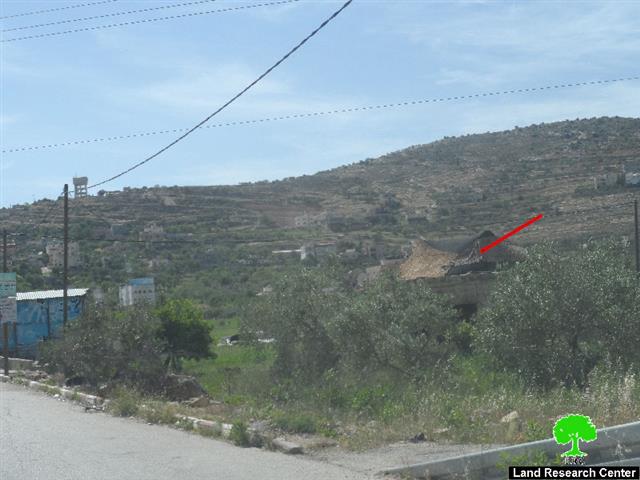
It should be marked that the Israeli Occupation Forces seized on  April 19, 2016 a house that is located at the entrance of Al-Lubban Al-Sharqiya village. The house of citizen Ihsan Daraghmeh is reported to be located nearby the bypass road number 60 and is being so far controlled by the occupation soldiers.

It is reported that the house has been abandoned since two years and that the occupation army takes it over every now and then to monitor residents movement in and out the village. Soldiers also restrict farmers movement and access to the village's valley that is considered a source of income for  many residents. Not only, the house was taken so many times by colonists, who drew hatred inciting slogans on its walls.

A major problem is that the seized house is located in middle of two primary schools; one for girls and the other is gender-mixed.  Such a checkpoint will negatively affect students on the psychological level, not mentioning the harassments school kids suffer when they bypass the checkpoint.


Photo 1+2: targeted house


About al-Lubban al-Sharqiya:

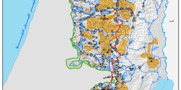
It is located 20km southwest of Nablus governorate. The village is surrounded by a number of towns and communities namely( al-Sawiya, Qaryut, Ammoriya, Yasuf, Singel, Abouyn, Salfit and Iskaka)

The village has a total land area of 12,075 of which 150 dunums is a built -up area. 240 dunums are considered agricultural lands for grains and vegetables plantation where another 700 dunums have been a  subject to colonial activities. The bypass road no.60 confiscated around 200 dumums where the rest of the land total area is planted with olive, almond and figs. (source: geographical information system GIS -LRC)

Awaysa and Daraghmeh clans are the two main families in the village where the population totals around 2900 people. The unemployment rate is around 51% due to closures, sieges, and lands confiscation. Only 14% of the residents are employed in different sectors such like the governmental and the private ones. Others depend on plantation as a source of living.( source: the town's village council).


Prepared by
 The Land Research Center
LRC
 

Recommended For You

بين قصرة وترمسعيا: العنف الاستيطاني الاسرائيلي يضرب المجتمع الفلسطيني

by arij
May 6, 2026
0

في الثالث من شهر أيار من العام 2026، شهد مزارعون في عدة قرى في الضفة الغربية المحتلة على مشهد بات مألوفًا وقاسيا في آنٍ واحد: أشجار مثمرة مقطوعة...

Read moreDetails

INFOGRAPHIC: ISRAELI SETTLER VIOLENCE IN 2025

by arij
April 16, 2026
0

INFOGRAPHIC: ISRAELI SETTLER VIOLENCE IN 2025     Prepared by:   The Applied Research Institute – Jerusalem  

Read moreDetails

أدوات غير مباشرة للاستيطان الإسرائيلي في مناطق (أ) و(ب) لإعادة تشكيل الجغرافيا والسيطرة في الضفة الغربية   

by arij
April 16, 2026
0
العدالة المؤجلة ورأي بلا تنفيذ: من قرار المحكمة إلى واقع الضم

منذ توقيع اتفاقيات أوسلو في تسعينيات القرن الماضي، تم تقسيم الضفة الغربية إلى ثلاث مناطق إدارية وأمنية: (أ)، (ب)، و(ج)، بهدف تنظيم المرحلة الانتقالية نحو تسوية نهائية. وبموجب...

Read moreDetails

INFOGRAPHIC: Palestinian Trees – Victims of the Israeli occupation Army & Settler Groups in 2025

by arij
April 16, 2026
0

    INFOGRAPHIC: Palestinian Trees - Victims of the Israeli occupation Army & Settler Groups in 2025 Prepared by:   The Applied Research Institute – Jerusalem  

Read moreDetails

ذكرى الـ 50 ليوم الأرض: فلسطين بين ذاكرة الدم وصمود البقاء    

by arij
April 16, 2026
0

في الثلاثين من آذار، لا يستحضر يوم الأرض في الوعي الفلسطيني بوصفه مناسبة رمزية عابرة، بل كحدث تأسيسي متجدد يعكس استمرارية الصراع على الأرض والهوية. وبعد مرور خمسين...

Read moreDetails
Next Post

ARIJ Daily Report - Thu, 21st 04 2016

LATEST NEWS

بين قصرة وترمسعيا: العنف الاستيطاني الاسرائيلي يضرب المجتمع الفلسطيني

by arij
May 6, 2026
0

........................................................

مناطق نفوذ المستوطنات ودورها في إعادة تشكيل الجغرافيا الفلسطينية

مناطق نفوذ المستوطنات ودورها في إعادة تشكيل الجغرافيا الفلسطينية

by arij
April 23, 2026
0

........................................................

التمدد الاستيطاني الإسرائيلي في الضفة الغربية المحتلة وأثره في تقويض مقومات الدولة الفلسطينية

التمدد الاستيطاني الإسرائيلي في الضفة الغربية المحتلة وأثره في تقويض مقومات الدولة الفلسطينية

by arij
April 16, 2026
0

........................................................

INFOGRAPHIC: ISRAELI SETTLER VIOLENCE IN 2025

by arij
April 16, 2026
0

........................................................

flag_yellow_lowEU-PfP-Logo

This website and its content were initiated in 1993 by the Applied Research Institute – Jerusalem (ARIJ) and the Land Research Center (LRC) with the support from the European Union up until 2023. Since then, the Applied Research Institute – Jerusalem (ARIJ) has taken over the continued development and maintenance of the website. The views expressed remain solely those of ARIJ) and do not necessarily reflect those of the European Union.

© 2026 Copyright | ARIJ | All Rights reserved.

No Result
View All Result
  • Home
  • Settlements
    • New Israeli Settlements
    • Settlement Expansion
  • Israeli Violations
    • Agriculture
    • Confiscation
    • Demolition
    • Environment
    • Eviction of Palestinians
    • Settlers Attacks
  • Bypass Roads
  • Israeli Plans
  • Segregation
    • Checkpoints
    • Closure
    • Separation Plans
  • Military Orders
  • Reports
    • Daily Report
    • Monthly Report
    • Quarterly Report

© 2026 Copyright | ARIJ | All Rights reserved.