• About The Project
  • Palestine in Century
  • Selected Maps
  • Glossary
  • About ARIJ
  • About LRC
  • By Year
    • Case Studies By Year
    • Daily Report By Year
Saturday, April 4, 2026
POICA
No Result
View All Result
  • Home
  • Settlements
    • New Israeli Settlements
    • Settlement Expansion
  • Israeli Violations
    • Agriculture
    • Confiscation
    • Demolition
    • Environment
    • Eviction of Palestinians
    • Settlers Attacks
  • Bypass Roads
  • Israeli Plans
  • Segregation
    • Checkpoints
    • Closure
    • Separation Plans
  • Military Orders
  • Reports
    • Daily Report
    • Monthly Report
    • Quarterly Report
No Result
View All Result
POICA
No Result
View All Result

The Geopolitical Status of Shu’fat Town

March 14, 2023
in Israeli Violations
The Geopolitical Status of Shu’fat Town


Location

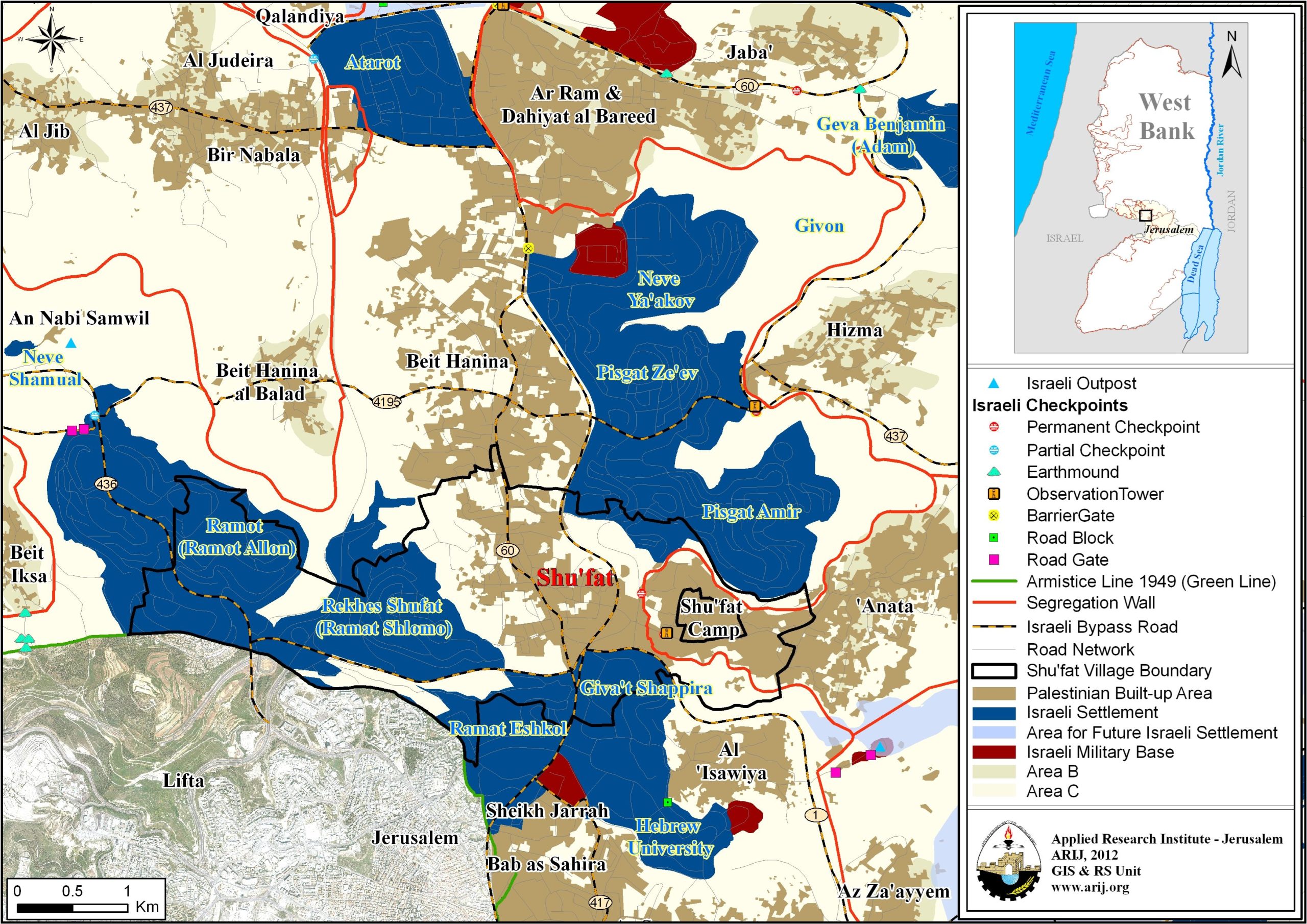
Shu’fat is a Palestinian town in Jerusalem Governorate located to its north City. It is bordered by Hizma and ‘Anata communities and the settlement of Pisgat Amir to the east, Beit Hanina and the settlement of Pisgat Zeev to the north, the settlements of Reches Shu’fat and Ramat Shlomo to the west, and the settlements of Giv’at Shapira nd Ramat Eshkol to the south (ARIJ, 2022) (see map 1). The town of Shu’fat is home to 23,890 Palestinians (JIPC, 2022), most of whom are Jerusalem ID holders.

Geopolitical status of Shu’fat town 

Most of the land of Shu’fat town, which covers an area of 8,494 dunums, is located under the control of Jerusalem Israeli Municipality, which was declared illegally and unilaterally in 1967 after the Israeli Occupation of the West Bank including East Jerusalem, the Gaza Strip and other Arab lands, except for a small area of land, around 59 dunums of land that is located outside the Jerusalem Municipal Boundary. Jerusalem Governorate was divided into two main regions. The first is the J1 area, which is located inside the borders and under the control of the Jerusalem Municipality. The J1 area includes many Palestinian Jerusalemite communities such as those in the Old Town and Jerusalem City (Beit Al-Maqdis), in addition to Shu’fat town which is located in the north of the J1 area. The other classified region is J2, which is located outside the borders and the control of Jerusalem Municipality. This area is under the Palestinian Authority’s control within Jerusalem Governorate and includes the eastern and western parts.

Full Report, Click Here 


Prepared by:  
The Applied Research Institute – Jerusalem

Recommended For You

الاحتلال الإسرائيلي يستهدف مشاريع تنموية في قرية جورة الشمعة جنوب شرق بيت لحم

by arij
March 14, 2026
0
الاحتلال الإسرائيلي يستهدف مشاريع تنموية في قرية جورة الشمعة جنوب شرق بيت لحم

في يوم الاربعاء الموافق الرابع من شهر اذار من العام من العام 2026, سلمت سلطات الاحتلال الاسرائيلي (الإدارة المدنية الاسرائيلية) أهالي قرية جورة الشمعة جنوب شرق مدينة بيت...

Read moreDetails

The West Bank: Between Settler Aggression and Occupation Support – 2025 Highlights

by arij
March 25, 2026
0
The West Bank: Between Settler Aggression and Occupation Support – 2025 Highlights

In the occupied West Bank (oWB), the violence committed by Israeli settlers is no longer a series of isolated, random attacks; it has effectively become a de facto...

Read moreDetails

Palestinian Trees … Victims of the Israeli Occupation Army and Settler groups in 2025

by arij
March 25, 2026
0
Palestinian Trees … Victims of the Israeli Occupation Army and Settler groups in 2025

Preface, In the occupied West Bank, the uprooting of Palestinian trees is not merely an assault on nature and environment; it is an act that strikes Palestinian culture,...

Read moreDetails

الضفة الغربية بين إرهاب المستوطنين وتواطؤ الاحتلال – حصيلة العام 2025

by arij
February 16, 2026
0
الضفة الغربية بين إرهاب المستوطنين وتواطؤ الاحتلال – حصيلة العام 2025

مقدمة: - في الضفة الغربية المحتلة، يتعدى عنف المستوطنين الإسرائيليين كونه سلسلة اعتداءات عشوائية تتم دون نهج معين، بل أصبح يشكّل سياسة أمر واقع تفرض بقوة السلاح على...

Read moreDetails

الأشجار الفلسطينية -جريمة بلا صوت – ضحية مزدوجة لجيش الاحتلال الاسرائيلي والمستوطنين خلال العام 2025

by arij
February 16, 2026
0
الأشجار الفلسطينية -جريمة بلا صوت – ضحية مزدوجة لجيش الاحتلال الاسرائيلي والمستوطنين خلال العام 2025

في الضفة الغربية المحتلة، لا يُعتبر اقتلاع الأشجار الفلسطينية مجرد اعتداء على الطبيعة والبيئة، بل هو فعلٌ يمس الثقافة والتاريخ والوجود الفلسطيني اذ يستهدف الإنسان والأرض معًا. فمنذ...

Read moreDetails
Next Post

ARIJ Daily Report – Mon 14th 11 2022

LATEST NEWS

سلطات الاحتلال الإسرائيلي تستهدف قرية الجيب بأمر عسكري جديد

سلطات الاحتلال الإسرائيلي تستهدف قرية الجيب بأمر عسكري جديد

by arij
March 17, 2026
0

........................................................

على ما مساحته 1006.4 دونما من أراضي بلدة يانون  “سلطات الاحتلال الإسرائيلي تشرع بتغيير نفوذ بؤرة استيطانية في الضفة الغربية المحتلة”

على ما مساحته 1006.4 دونما من أراضي بلدة يانون
“سلطات الاحتلال الإسرائيلي تشرع بتغيير نفوذ بؤرة استيطانية في الضفة الغربية المحتلة”

by arij
March 14, 2026
0

........................................................

الاحتلال الإسرائيلي يستهدف مشاريع تنموية في قرية جورة الشمعة جنوب شرق بيت لحم

الاحتلال الإسرائيلي يستهدف مشاريع تنموية في قرية جورة الشمعة جنوب شرق بيت لحم

by arij
March 14, 2026
0

........................................................

سلطات الاحتلال الإسرائيلي تستخدم الأوامر العسكرية لتعمق المشروع الاستيطاني في الضفة الغربية المحتلة

سلطات الاحتلال الإسرائيلي تستخدم الأوامر العسكرية لتعمق المشروع الاستيطاني في الضفة الغربية المحتلة

by arij
February 26, 2026
0

........................................................

flag_yellow_lowEU-PfP-Logo

This website and its content were initiated in 1993 by the Applied Research Institute – Jerusalem (ARIJ) and the Land Research Center (LRC) with the support from the European Union up until 2023. Since then, the Applied Research Institute – Jerusalem (ARIJ) has taken over the continued development and maintenance of the website. The views expressed remain solely those of ARIJ) and do not necessarily reflect those of the European Union.

© 2026 Copyright | ARIJ | All Rights reserved.

No Result
View All Result
  • Home
  • Settlements
    • New Israeli Settlements
    • Settlement Expansion
  • Israeli Violations
    • Agriculture
    • Confiscation
    • Demolition
    • Environment
    • Eviction of Palestinians
    • Settlers Attacks
  • Bypass Roads
  • Israeli Plans
  • Segregation
    • Checkpoints
    • Closure
    • Separation Plans
  • Military Orders
  • Reports
    • Daily Report
    • Monthly Report
    • Quarterly Report

© 2026 Copyright | ARIJ | All Rights reserved.