• About The Project
  • Palestine in Century
  • Selected Maps
  • Glossary
  • About ARIJ
  • About LRC
  • By Year
    • Case Studies By Year
    • Daily Report By Year
Saturday, April 25, 2026
POICA
No Result
View All Result
  • Home
  • Settlements
    • New Israeli Settlements
    • Settlement Expansion
  • Israeli Violations
    • Agriculture
    • Confiscation
    • Demolition
    • Environment
    • Eviction of Palestinians
    • Settlers Attacks
  • Bypass Roads
  • Israeli Plans
  • Segregation
    • Checkpoints
    • Closure
    • Separation Plans
  • Military Orders
  • Reports
    • Daily Report
    • Monthly Report
    • Quarterly Report
No Result
View All Result
POICA
No Result
View All Result

Halt of Work Notices for 12 Houses in Yetma / South Nablus

March 9, 2022
in Military Orders
Halt of Work Notices for 12 Houses in Yetma / South Nablus


  • Violations: Halt of Work notices.
  • Date: February 14th 2021.
  • Location: Yatma town / Nablus governorate.
  • Perpetrators: The Israeli Civil Administration.
  • Victims: 12 people at Yatma village.

Description:

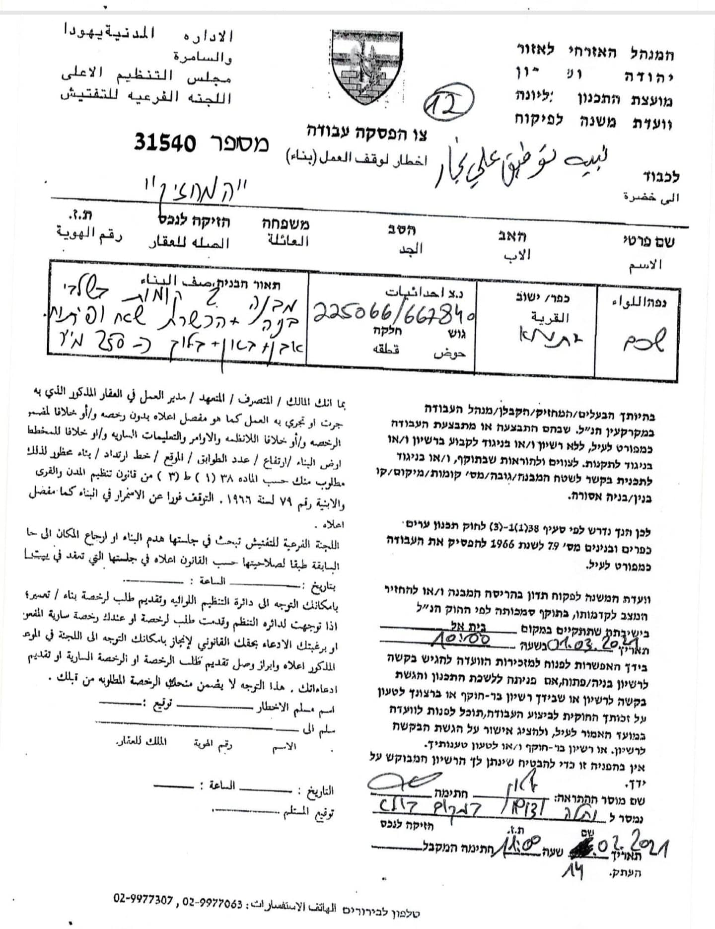
February 14th 2021, The Israeli Occupation authorities served a halt of work notice for 12 houses on the pretext of building without a license, in Yatma south Hebron.

Yatma village council head Mohammed Snobar said: “ a massive army force accompanied by the civil administration raided the village, the building inspector wrote the notices , hanged them on the targeted structures, and took pictures of them before withdrawing.”

The Occupation authorities ordered the immediate stoppage of construction works at the house , and sat March 1st 2021, as the date of the building and organization session in Beit El military court to decide the fate of the structures.

Yatma village council head said that the affected citizens contacted the Legal Aid and Human Rights Center in Jerusalem for legal aid , And the later submitted objections on the notices.

The following table shows more information about the targeted structures:

Affected citizen

Area m2

Military order number

The targeted facility

Nabeeh Najjar

250

31540

Under construction house / two floors +an excavated area

Mohammed Abdulqader

700

31541

Under construction house / surrounded by a wall 

Ibeahim Najjar

250

31542

One floor house / under construction + preparations for a second floor

Yazeed Khdair

700

31530

Two floors house ready and inhabited + a nearby building

Nidal Snoubar

700

31531

Inhabited Two floors house + a nearby building

Iyad Abu Baker

750

51532

Two floors building inhabited + a nearby building

Mesa’ab Abu Baker

600

31534

Two floors house + surrounded by a bricks wall

Mahmoud Najjar

250

31535

3 floors house / ready to be inhabited

Anas Farah

400

31536

Two floors house / ready to be inhabited

Mo’en Najjar

1000

31537

Four floor house under construction + an excavated area

Mohammed Najjar

1000

31538

Two floors house under construction + baton floor around it

Muhie Najjar

200

31539

Two floors house inhabited + baton wall around it


About Yatma village:[1]
14 Km south Nablus city , Yatma is surrounded by Bita (North), As-Sawiya and Yasuf (west), Qablan (east) and As-Sawiya village (south). Yatma has a total population of 2853 people according to 2007 censusÙˆ with a total area of 2952 dunums , of which 392 dunums are a built up area for the village.
Bypass roads devoured 164 dunums , as segments of bypasses 60 and 505 pass-through the village . Oslo accords divided the village’s lands as the following:
• B area : with a total area of 912 dunums (31%).
• C area: with a total area of 2040 dunums (69%).

[1] GIS-LRC


Prepared by
 The Land Research Center
LRC

Recommended For You

مناطق نفوذ المستوطنات ودورها في إعادة تشكيل الجغرافيا الفلسطينية

by arij
April 23, 2026
0
مناطق نفوذ المستوطنات ودورها في إعادة تشكيل الجغرافيا الفلسطينية

أصدرت سلطات الاحتلال الإسرائيلي في العاشر من شهر نيسان 2026 الكراسة رقم (273)، وهي وثيقة تضم مجموعة من المناشير والأوامر والتعيينات الإسرائيلية المتعلقة بالجوانب الأمنية والعسكرية والإدارية، إضافة...

Read moreDetails

INFOGRAPHIC: Mapping Control – Israeli Militray Orders across the occupied West Bank – 2025

by arij
April 16, 2026
0

    Prepared by:   The Applied Research Institute – Jerusalem

Read moreDetails

سلطات الاحتلال الإسرائيلي تستهدف قرية الجيب بأمر عسكري جديد

by arij
March 17, 2026
0
سلطات الاحتلال الإسرائيلي تستهدف قرية الجيب بأمر عسكري جديد

نشر المسؤول عن الأملاك الحكومية وأملاك الغائبين في الإدارة المدنية الإسرائيلية في الحادي عشر من شهر اذار من العام 2026 اعلاننا مفاده نية ما يسمى " المسؤول عن...

Read moreDetails

سلطات الاحتلال الإسرائيلي تستخدم الأوامر العسكرية لتعمق المشروع الاستيطاني في الضفة الغربية المحتلة

by arij
February 26, 2026
0
سلطات الاحتلال الإسرائيلي تستخدم الأوامر العسكرية لتعمق المشروع الاستيطاني في الضفة الغربية المحتلة

تقديم منذ احتلال الضفة الغربية عام 1967، اعتمدت سلطات الاحتلال الإسرائيلي منهجية واسعة عبر استخدام الأوامر العسكرية كأداة "قانونية" لفرض الوقائع الجغرافية والديموغرافية على الأرض الفلسطينية. وأصبحت هذه...

Read moreDetails

بين مطرقة الأوامر العسكرية وسندان التقييد الجغرافي, أوامر عسكرية إسرائيلية جديدة تطال أكثر من 1000 دونم في طوباس

by arij
November 26, 2025
0
بين مطرقة الأوامر العسكرية وسندان التقييد الجغرافي, أوامر عسكرية إسرائيلية جديدة تطال أكثر من 1000 دونم في طوباس

في الحادي والعشرين من شهر تشرين الأول لعام 2025، تسلّم أهالي محافظة طوباس سلسلة من الأوامر العسكرية الإسرائيلية التي استهدفت مساحات واسعة من الأراضي الفلسطينية في المحافظة. وقد...

Read moreDetails
Next Post
تدمير منزل عائلة الأسير محمود جرادات في قرية سيلة الحارثية / محافظة جنين

تدمير منزل عائلة الأسير محمود جرادات في قرية سيلة الحارثية / محافظة جنين

LATEST NEWS

مناطق نفوذ المستوطنات ودورها في إعادة تشكيل الجغرافيا الفلسطينية

مناطق نفوذ المستوطنات ودورها في إعادة تشكيل الجغرافيا الفلسطينية

by arij
April 23, 2026
0

........................................................

التمدد الاستيطاني الإسرائيلي في الضفة الغربية المحتلة وأثره في تقويض مقومات الدولة الفلسطينية

التمدد الاستيطاني الإسرائيلي في الضفة الغربية المحتلة وأثره في تقويض مقومات الدولة الفلسطينية

by arij
April 16, 2026
0

........................................................

INFOGRAPHIC: ISRAELI SETTLER VIOLENCE IN 2025

by arij
April 16, 2026
0

........................................................

العدالة المؤجلة ورأي بلا تنفيذ: من قرار المحكمة إلى واقع الضم

أدوات غير مباشرة للاستيطان الإسرائيلي في مناطق (أ) و(ب) لإعادة تشكيل الجغرافيا والسيطرة في الضفة الغربية   

by arij
April 16, 2026
0

........................................................

flag_yellow_lowEU-PfP-Logo

This website and its content were initiated in 1993 by the Applied Research Institute – Jerusalem (ARIJ) and the Land Research Center (LRC) with the support from the European Union up until 2023. Since then, the Applied Research Institute – Jerusalem (ARIJ) has taken over the continued development and maintenance of the website. The views expressed remain solely those of ARIJ) and do not necessarily reflect those of the European Union.

© 2026 Copyright | ARIJ | All Rights reserved.

No Result
View All Result
  • Home
  • Settlements
    • New Israeli Settlements
    • Settlement Expansion
  • Israeli Violations
    • Agriculture
    • Confiscation
    • Demolition
    • Environment
    • Eviction of Palestinians
    • Settlers Attacks
  • Bypass Roads
  • Israeli Plans
  • Segregation
    • Checkpoints
    • Closure
    • Separation Plans
  • Military Orders
  • Reports
    • Daily Report
    • Monthly Report
    • Quarterly Report

© 2026 Copyright | ARIJ | All Rights reserved.