• About The Project
  • Palestine in Century
  • Selected Maps
  • Glossary
  • About ARIJ
  • About LRC
  • By Year
    • Case Studies By Year
    • Daily Report By Year
Monday, June 8, 2026
POICA
No Result
View All Result
  • Home
  • Settlements
    • New Israeli Settlements
    • Settlement Expansion
  • Israeli Violations
    • Agriculture
    • Confiscation
    • Demolition
    • Environment
    • Eviction of Palestinians
    • Settlers Attacks
  • Bypass Roads
  • Israeli Plans
  • Segregation
    • Checkpoints
    • Closure
    • Separation Plans
  • Military Orders
  • Reports
    • Daily Report
    • Monthly Report
    • Quarterly Report
No Result
View All Result
POICA
No Result
View All Result

The Israeli Occupation Targets Artesian Water Cisterns in Beit Ummar / North Hebron

January 12, 2022
in Military Orders
The Israeli Occupation Targets Artesian Water Cisterns in Beit Ummar / North Hebron


  • Violation: Demolition orders target cisterns.
  • Date: October 12th 2021.
  • Location: Ath-Thughra – Beit Ummar / Hebron Governorate.
  • Perpetrators: The Israeli Civil Administration.
  • Victims: A number of farmers in Beit Ummar.

Description:

A part of the Israeli Occupation Policies that aims to control water resources at the west bank, the occupation authorities served notices to a number of artesian water cisterns, on the pretext of  extracting artesian water without a license from Israeli West Bank Army Commander .

Reportedly, the occupation served stop-work notices in Beit Ummar south Hebron , followed by demolition orders for number of cisterns used to collect artesian water that farmers had extracted from their own lands.

Noteworthy, Ath-Thughra is an agricultural area the contains several green houses, where many farmers found artesian water 50 m deep under the ground in their farmlands.

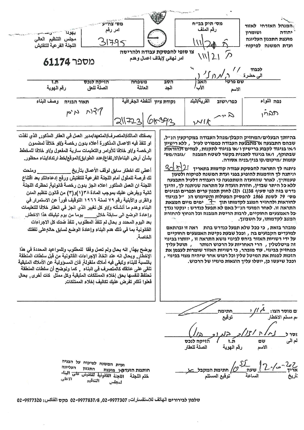
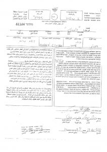
However, in October 12th 2021 , the occupation authorities issued demolition orders for 10 cisterns at the area , and threatened to demolish them within  7 days.

One of the farmers , Nabeel Ibreghith (52) testified that the occupation authorities issued demolition orders for 8 cisterns at his agricultural lands in Ath-Thughra , which he used to irrigate (45 dunums) planted with vegetable.

In addition, the occupation issued demolition orders for two cisterns belong to citizen Taha Abu Marya at the area, who uses the water to irrigate an agricultural area of 10 dunums planted with vegetables.

Note: attached Demolition order and a map


Burying cisterns:

In November 4th 2021, the Israeli occupation forces closed several cisterns in Ath-Thughra area , though burying them with cement.

One of them belongs to citizen Bassam ‘Addi , who used to irrigate a plot and green houses on an area of 15 dunums planted with vegetables the troops also buried a cistern in citizen Mohammed Abu Ayyash land, that used to provide water for 8 dunums , each one of the springs produces 70 m3 of water during 24 hours.

In case the occupation authorities destroyed water resources at the area, there will be an economical and agricultural crisis, as many families at the village depend on agriculture as a main source of income.

Noteworthy, shortly after Israel occupied the west bank again in 1967 , they sent a water and exploration mission , and issued many military orders that restrict Palestinians’ access to their water resources.

Israeli Military Orders issued to deny Palestinian access to their water resources:

  • An Order issued in June 7th 1997 stating: “all the water resources that have been occupied again are the property of the state of Israel”.
  • Order No. 92 issued in August 15th 1997 , gives the Israeli authorities complete control over the entire water supplies in the West Bank and Gaza. Only the Head, appointed by the Area Commander, has influence in any issue regarding “transportation, extraction, export, consumption, sale, distribution, inspection of its use, purification, allotment of shares, the establishment of water projects
  • Order No.58 issued in August 19th 1967: states that ″it is prohibited to construct any new water installation without a license and that the licensing officer has the right of rejecting any application for a license without having to give the justification for his rejection.
  • Order No. 158 (1967): “Order Amending the Water Supervision Law” ordained that all wells, springs and water projects are under the full direct command of the Israeli Military Commander. Every installation or resource built without a permit will be confiscated.
  • Order No. 291 (1968). All pre-1967 land and water-related arrangements are declared invalid.
  • Order No. 948 states that every citizen in the Gaza Strip is compelled to obtain the approval of the Israeli military commander before implementing any water-related project.


Prepared by
 The Land Research Center
LRC

Recommended For You

سلطات الاحتلال الإسرائيلي بصدد الاستيلاء على موقع قبر النبي صموئيل شمال غرب مدينة القدس

by arij
May 23, 2026
0
سلطات الاحتلال الإسرائيلي بصدد الاستيلاء على موقع قبر النبي صموئيل شمال غرب مدينة القدس

 نشرت سلطات الاحتلال الإسرائيلي في الثامن عشر من شهر أيار من العام 2026 اعلانا مفاده الاستيلاء على الأراضي الفلسطينية في قرية النبي صموئيل شمال غرب القدس المحتلة. وجاء...

Read moreDetails

إقامة منطقة عسكرية عسكرية داخل أراضي (أ) في جنين

by arij
May 19, 2026
0
إقامة منطقة عسكرية عسكرية داخل أراضي (أ) في جنين

   في السابع من شهر أيار من العام 2026، وزعت سلطات الاحتلال الإسرائيلي أمرا عسكريا جديدة على أهالي مدينة جنين يقضي بمصادرة 7.2 دونما من الأراضي الفلسطينية في...

Read moreDetails

“بمساحة اجمالية 177 دونما من أرضي البيرة وبيتين”, طريق استيطاني لخدمة البؤر الاستيطانية في محافظة رام الله

by arij
May 18, 2026
0
“بمساحة اجمالية 177 دونما من أرضي البيرة وبيتين”, طريق استيطاني لخدمة البؤر الاستيطانية في محافظة رام الله

في الحادي عشر من شهر أيار من العام 2026, نشرت دائرة أراضي إسرائيل اعلانا جديدا يقضي بمصادرة المزيد من الأراضي الفلسطينية في محافظة رام الله لأغراض استيطانية في...

Read moreDetails

“في خدمة مستوطنة ناحال حيلتس”, طريق استيطاني إسرائيلي جديد على أراضي بتير وبيت جالا في محافظة بيت لحم

by arij
May 18, 2026
0
“في خدمة مستوطنة ناحال حيلتس”, طريق استيطاني إسرائيلي جديد على أراضي بتير وبيت جالا في محافظة بيت لحم

تواصل سلطات الاحتلال الإسرائيلي إحكام سيطرتها على المزيد من الأراضي الفلسطينية في الضفة الغربية المحتلة، وهذه المرة من خلال استهداف أراضي محافظة بيت لحم. ففي السادس والعشرين من...

Read moreDetails

مناطق نفوذ المستوطنات ودورها في إعادة تشكيل الجغرافيا الفلسطينية

by arij
April 23, 2026
0
مناطق نفوذ المستوطنات ودورها في إعادة تشكيل الجغرافيا الفلسطينية

أصدرت سلطات الاحتلال الإسرائيلي في العاشر من شهر نيسان 2026 الكراسة رقم (273)، وهي وثيقة تضم مجموعة من المناشير والأوامر والتعيينات الإسرائيلية المتعلقة بالجوانب الأمنية والعسكرية والإدارية، إضافة...

Read moreDetails
Next Post
الاحتلال يستهدف ينابيع المياه في بلدة بيت أمر شمال الخليل

الاحتلال يستهدف ينابيع المياه في بلدة بيت أمر شمال الخليل

LATEST NEWS

سلطات الاحتلال الإسرائيلي بصدد الاستيلاء على موقع قبر النبي صموئيل شمال غرب مدينة القدس

سلطات الاحتلال الإسرائيلي بصدد الاستيلاء على موقع قبر النبي صموئيل شمال غرب مدينة القدس

by arij
May 23, 2026
0

........................................................

إقامة منطقة عسكرية عسكرية داخل أراضي (أ) في جنين

إقامة منطقة عسكرية عسكرية داخل أراضي (أ) في جنين

by arij
May 19, 2026
0

........................................................

الآثار كأداة للضم الزاحف: مشروع القانون الإسرائيلي لإعادة هندسة الجغرافيا والهوية في الضفة الغربية

الآثار كأداة للضم الزاحف: مشروع القانون الإسرائيلي لإعادة هندسة الجغرافيا والهوية في الضفة الغربية

by arij
May 23, 2026
0

........................................................

النكبة الفلسطينية في ذكراها الثامنة والسبعين: من التطهير العرقي إلى الإبادة وإعادة هندسة الجغرافيا الفلسطينية 

النكبة الفلسطينية في ذكراها الثامنة والسبعين: من التطهير العرقي إلى الإبادة وإعادة هندسة الجغرافيا الفلسطينية 

by arij
May 18, 2026
0

........................................................

flag_yellow_lowEU-PfP-Logo

This website and its content were initiated in 1993 by the Applied Research Institute – Jerusalem (ARIJ) and the Land Research Center (LRC) with the support from the European Union up until 2023. Since then, the Applied Research Institute – Jerusalem (ARIJ) has taken over the continued development and maintenance of the website. The views expressed remain solely those of ARIJ) and do not necessarily reflect those of the European Union.

© 2026 Copyright | ARIJ | All Rights reserved.

No Result
View All Result
  • Home
  • Settlements
    • New Israeli Settlements
    • Settlement Expansion
  • Israeli Violations
    • Agriculture
    • Confiscation
    • Demolition
    • Environment
    • Eviction of Palestinians
    • Settlers Attacks
  • Bypass Roads
  • Israeli Plans
  • Segregation
    • Checkpoints
    • Closure
    • Separation Plans
  • Military Orders
  • Reports
    • Daily Report
    • Monthly Report
    • Quarterly Report

© 2026 Copyright | ARIJ | All Rights reserved.