• About The Project
  • Palestine in Century
  • Selected Maps
  • Glossary
  • About ARIJ
  • About LRC
  • By Year
    • Case Studies By Year
    • Daily Report By Year
Friday, May 22, 2026
POICA
No Result
View All Result
  • Home
  • Settlements
    • New Israeli Settlements
    • Settlement Expansion
  • Israeli Violations
    • Agriculture
    • Confiscation
    • Demolition
    • Environment
    • Eviction of Palestinians
    • Settlers Attacks
  • Bypass Roads
  • Israeli Plans
  • Segregation
    • Checkpoints
    • Closure
    • Separation Plans
  • Military Orders
  • Reports
    • Daily Report
    • Monthly Report
    • Quarterly Report
No Result
View All Result
POICA
No Result
View All Result

Notifying fences and retaining walls in Ni’lin / Ramallah governorate

February 29, 2020
in Military Orders
الاحتلال يخطر بوقف البناء تطال أسوار وجدران استنادية في بلدة نعلين / محافظة رام الله


  • Violation : halt of work notices.
  • Location: Ni’lin village / North West Ramallah.
  • Date: January 7th 2020.
  • Perpetrator: The building and organization department – The Israeli Occupation Civil administration.
  • Victims: two families from the village.

Description:

Tuesday January 7 , The Israeli Occupation forces accompanied by members from the building and organization department in the civil administration raided Ni’lin village North West Ramallah . Ni’lin is adjacent to the apartheid wall that overviews the grand colonial cluster “Modi’in”.

The occupation targeted under construction agricultural projects, through notifying number of retaining walls that surround the plot on the pretext of building without licenses, the occupation set January 21st as a final date for the subcommittee session to decide the fate of the structure.

The following table shows more information about the damages:

Affected citizen

Family members

Military order number

Nature of the targeted facility

Ahmad ‘Umaira

8

00225

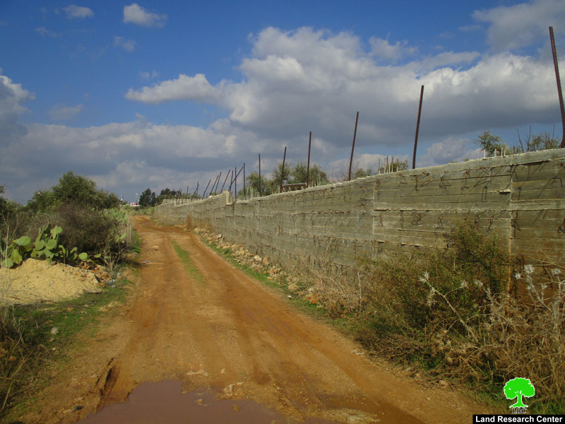
Baton wall (2 m*400m ) and surrounds a 4 dunums plot.

Sebty Al-Khawaja

5

00226

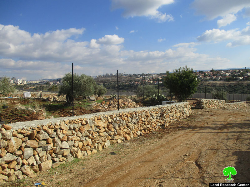
Retaining walls built of rocks (1 m*300 m) around a 5 dunums plot


13


Photos 1-5: Baton walls belong to ‘Umaira family

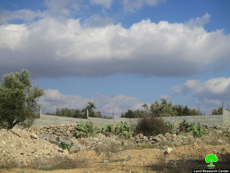
Photos 6-10: threatened retaining walls that belong to Al-Khawaja family


Affected citizen Sabty Al-Khawaja told LRC:

“two months ago, I carried on rehabilitating a plot that is only 15 m away from the apartheid wall south west Ni’lin, my intention was  to plant the plot and protect it with retaining walls , I worked so hard on this project , but only few days ago when I went to my plot I found a halt of work notice there , on the pretext of working without licenses , while all I built was retaining walls , but the occupation’s intention is to prohibit us from using our land, in order to keep it as a colonial reserve.”

According to LRC reports, the occupation notified tens of residential and agricultural structures in the village , they also demolished number of industrial facilities in an area known of “Al-Muhallel” in the village. With this, the occupation deprives Palestinians of their basic civil rights.

About Ni’lin:[1]

20 km to the northwest of Ramallah, Ni’lin is edged by the towns of Qibya and Budrus from the north, Al-Midyah town from the southwest, Deir Qidees town from the east and Mod’in and Kiryat Sefer colonies from the south.

Ni’lin is inhabited by 5897 people on a total land area of 15,206 dunums , of which 748 dunums are the village’s built-up area.

The occupation confiscated a total of 3020 dunums for colonial ends, which are detailed as follows:

  • Hashmona’im colony: it was established in 1985 on confiscated area of 858 dunums from the village. It is now inhabited by 2097 colonists.
  • Kiryat Sefer: it was established in 1991 on confiscated area of 476 dunums from the village. It is now inhabited by 24,290 colonists.
  • Mattityahu colony: it was established in 1980 on confiscated area of 657 dunums from the village. It is now inhabited by 1365 colonists.
  • Colonial bypass road number 446confiscated 408 dunums 
  • The apartheid wallconfiscated 621 dunums for the favor of its construction and isolated 14,083 behind it.

According to Oslo Accords lands classifications, Ni’lin lands are classified as follows:

  • 1,123 dunums are classified as area “B”
  • 14,083 dunums are classified as area “C”


[1] GIS-LRC


Prepared by

 The Land Research Center
LRC

Recommended For You

إقامة منطقة عسكرية عسكرية داخل أراضي (أ) في جنين

by arij
May 19, 2026
0
إقامة منطقة عسكرية عسكرية داخل أراضي (أ) في جنين

   في السابع من شهر أيار من العام 2026، وزعت سلطات الاحتلال الإسرائيلي أمرا عسكريا جديدة على أهالي مدينة جنين يقضي بمصادرة 7.2 دونما من الأراضي الفلسطينية في...

Read moreDetails

“بمساحة اجمالية 177 دونما من أرضي البيرة وبيتين”, طريق استيطاني لخدمة البؤر الاستيطانية في محافظة رام الله

by arij
May 18, 2026
0
“بمساحة اجمالية 177 دونما من أرضي البيرة وبيتين”, طريق استيطاني لخدمة البؤر الاستيطانية في محافظة رام الله

في الحادي عشر من شهر أيار من العام 2026, نشرت دائرة أراضي إسرائيل اعلانا جديدا يقضي بمصادرة المزيد من الأراضي الفلسطينية في محافظة رام الله لأغراض استيطانية في...

Read moreDetails

“في خدمة مستوطنة ناحال حيلتس”, طريق استيطاني إسرائيلي جديد على أراضي بتير وبيت جالا في محافظة بيت لحم

by arij
May 18, 2026
0
“في خدمة مستوطنة ناحال حيلتس”, طريق استيطاني إسرائيلي جديد على أراضي بتير وبيت جالا في محافظة بيت لحم

تواصل سلطات الاحتلال الإسرائيلي إحكام سيطرتها على المزيد من الأراضي الفلسطينية في الضفة الغربية المحتلة، وهذه المرة من خلال استهداف أراضي محافظة بيت لحم. ففي السادس والعشرين من...

Read moreDetails

مناطق نفوذ المستوطنات ودورها في إعادة تشكيل الجغرافيا الفلسطينية

by arij
April 23, 2026
0
مناطق نفوذ المستوطنات ودورها في إعادة تشكيل الجغرافيا الفلسطينية

أصدرت سلطات الاحتلال الإسرائيلي في العاشر من شهر نيسان 2026 الكراسة رقم (273)، وهي وثيقة تضم مجموعة من المناشير والأوامر والتعيينات الإسرائيلية المتعلقة بالجوانب الأمنية والعسكرية والإدارية، إضافة...

Read moreDetails

INFOGRAPHIC: Mapping Control – Israeli Militray Orders across the occupied West Bank – 2025

by arij
April 16, 2026
0

    Prepared by:   The Applied Research Institute – Jerusalem

Read moreDetails
Next Post
الاحتلال يخطر بوقف البناء تطال أسوار وجدران استنادية في بلدة نعلين / محافظة رام الله

الاحتلال يخطر بوقف البناء تطال أسوار وجدران استنادية في بلدة نعلين / محافظة رام الله

LATEST NEWS

إقامة منطقة عسكرية عسكرية داخل أراضي (أ) في جنين

إقامة منطقة عسكرية عسكرية داخل أراضي (أ) في جنين

by arij
May 19, 2026
0

........................................................

النكبة الفلسطينية في ذكراها الثامنة والسبعين: من التطهير العرقي إلى الإبادة وإعادة هندسة الجغرافيا الفلسطينية 

النكبة الفلسطينية في ذكراها الثامنة والسبعين: من التطهير العرقي إلى الإبادة وإعادة هندسة الجغرافيا الفلسطينية 

by arij
May 18, 2026
0

........................................................

“بمساحة اجمالية 177 دونما من أرضي البيرة وبيتين”, طريق استيطاني لخدمة البؤر الاستيطانية في محافظة رام الله

“بمساحة اجمالية 177 دونما من أرضي البيرة وبيتين”, طريق استيطاني لخدمة البؤر الاستيطانية في محافظة رام الله

by arij
May 18, 2026
0

........................................................

“في خدمة مستوطنة ناحال حيلتس”, طريق استيطاني إسرائيلي جديد على أراضي بتير وبيت جالا في محافظة بيت لحم

“في خدمة مستوطنة ناحال حيلتس”, طريق استيطاني إسرائيلي جديد على أراضي بتير وبيت جالا في محافظة بيت لحم

by arij
May 18, 2026
0

........................................................

flag_yellow_lowEU-PfP-Logo

This website and its content were initiated in 1993 by the Applied Research Institute – Jerusalem (ARIJ) and the Land Research Center (LRC) with the support from the European Union up until 2023. Since then, the Applied Research Institute – Jerusalem (ARIJ) has taken over the continued development and maintenance of the website. The views expressed remain solely those of ARIJ) and do not necessarily reflect those of the European Union.

© 2026 Copyright | ARIJ | All Rights reserved.

No Result
View All Result
  • Home
  • Settlements
    • New Israeli Settlements
    • Settlement Expansion
  • Israeli Violations
    • Agriculture
    • Confiscation
    • Demolition
    • Environment
    • Eviction of Palestinians
    • Settlers Attacks
  • Bypass Roads
  • Israeli Plans
  • Segregation
    • Checkpoints
    • Closure
    • Separation Plans
  • Military Orders
  • Reports
    • Daily Report
    • Monthly Report
    • Quarterly Report

© 2026 Copyright | ARIJ | All Rights reserved.