• About The Project
  • Palestine in Century
  • Selected Maps
  • Glossary
  • About ARIJ
  • About LRC
  • By Year
    • Case Studies By Year
    • Daily Report By Year
Monday, April 27, 2026
POICA
No Result
View All Result
  • Home
  • Settlements
    • New Israeli Settlements
    • Settlement Expansion
  • Israeli Violations
    • Agriculture
    • Confiscation
    • Demolition
    • Environment
    • Eviction of Palestinians
    • Settlers Attacks
  • Bypass Roads
  • Israeli Plans
  • Segregation
    • Checkpoints
    • Closure
    • Separation Plans
  • Military Orders
  • Reports
    • Daily Report
    • Monthly Report
    • Quarterly Report
No Result
View All Result
POICA
No Result
View All Result

Extending the Validity of Closing Thousands of Dunums in the Jordan Valley

August 28, 2019
in Military Orders
Extending the Validity of Closing Thousands of Dunums in the Jordan Valley

Violation: extending the validity of a closure.

Location: Tayasir, Tamoun / Tubas city.

Date: 04/04/2019.

Perpetrator: The Israeli occupation army.

Victims: Number of Palestinian communities.

Description:

The Israeli occupation army commander in West Bank “Nedav Alof” issued a military order extending the validity of the closure of vast areas in the Jordan valley, and annexing 101.3 dunums to the closed area , under “security” claims.

The military order (T /11/99) entitled “area closure, modification of borders” , extends the validity of closing 49229 dunums in addition to other 101.3 dunums until 2021.

Noteworthy, the newly annexed area was also targeted by military order (19/3/T) , that informs the confiscation of 283 dunums from the Jordan valley.

Through the Israeli “Emergencies’ Law” , which is activated since 1966 , the illegal occupiers gave themselves the right to confiscate Palestinian lands for Security claims, the law was excessively used in the confiscation of wide areas of Palestinian lands at the Jordan Valley , in addition to imposing movement and building restrictions.

Reportedly, the closed area is located between “Maskiyyot” illegal Israeli settlement (North)and “Roi” illegal Israeli settlement (south) to Yarza hamlet and At-Tayaseer Israeli military camp (West), while the newly closed area is north “Saorah” military camp.

Noteworthy the closed area consists of several Bedouin communities: Such as Khirbet Yarza, Al-Mayta, Al-Burj, Hamamat Al-Malih,  Ein Al-Hilweh, Al-Faw and Khirbet Umm Al-Qaba, the communities are populated of about 690 people , they live under restrictions that hinder their movement, and natural expansion.

About 9 % of the closed military zones are privately owned Palestinian lands , that belong to farmers from Tubas, 79 % , the occupation considers “state’s properties”, while the rest are absentees properties.

The following table shows more information about the targeted area:

Closed area

village

The newly closed area

governorate

Natural block

Piece number

49229.4 dunums

At-Tayaseer, Tubas, Tamoun

101.3

Tubas

255

1.2.32

253

“0” road between pieces , 9.5-15.14.11

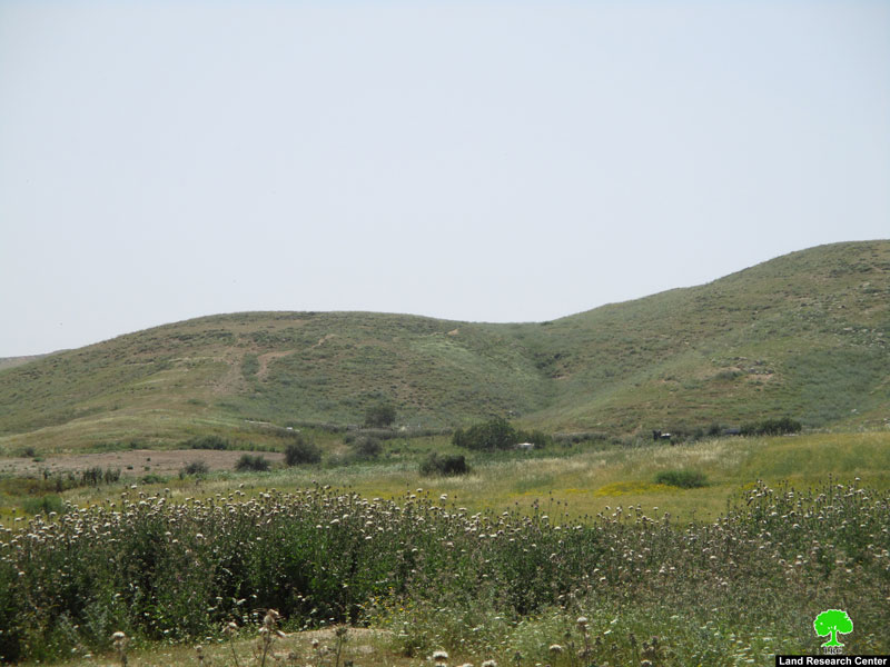
Photos 1-5: a view of the closed zones

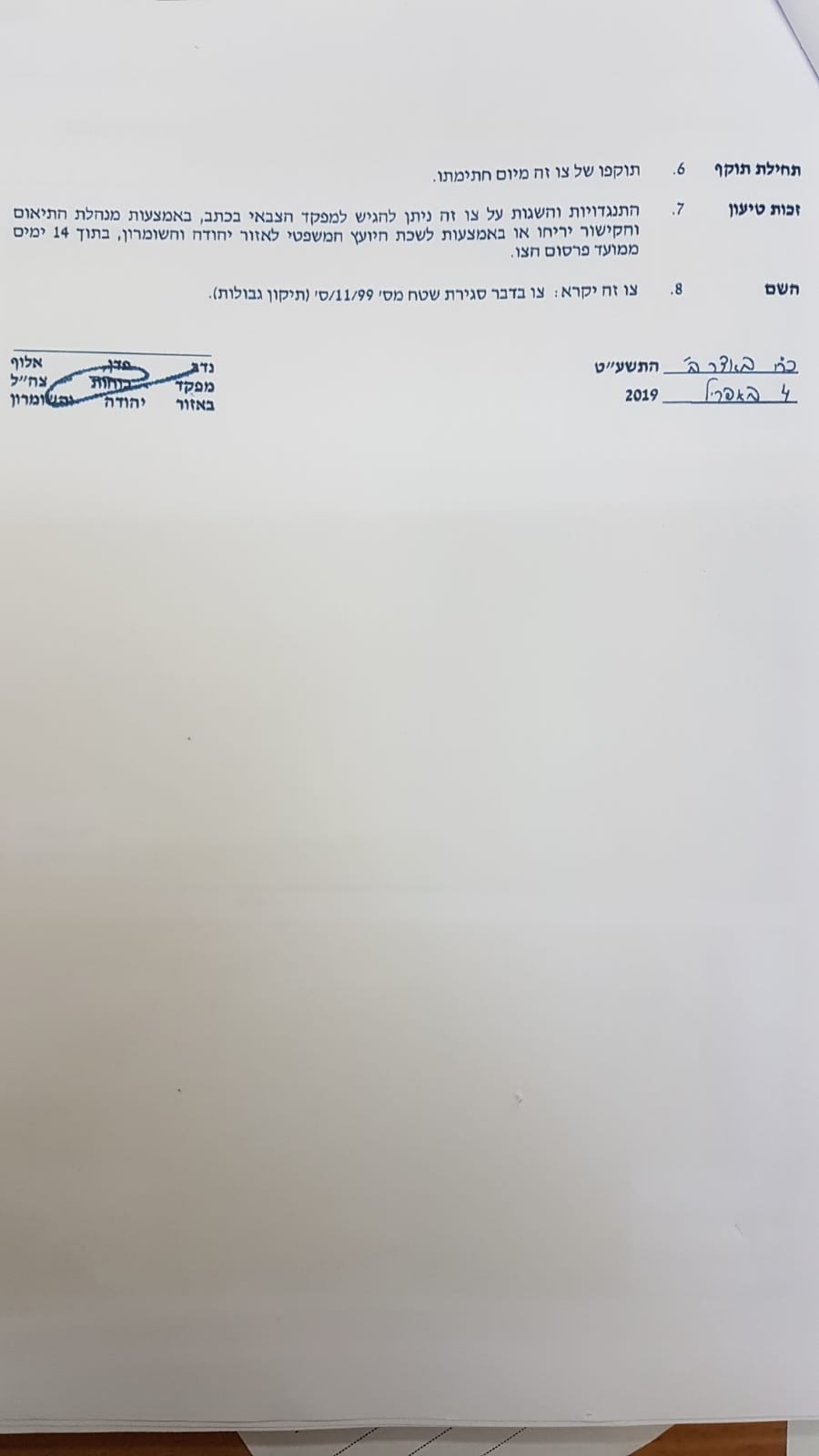
The attachment of the military order

The International Covenant on Civil and Political Rights:

  1. All peoples may, for their own ends, freely dispose of their natural wealth and resources without prejudice to any obligations arising out of international economic co-operation, based upon the principle of mutual benefit, and international law. In no case may a people be deprived of its own means of subsistence.

Article 17 of the international Declaration of Human Rights:

  1. Everyone has the right to own property alone as well as in association with others.
  2. No one shall be arbitrarily deprived of his property.


Prepared by
 The Land Research Center
LRC


Recommended For You

مناطق نفوذ المستوطنات ودورها في إعادة تشكيل الجغرافيا الفلسطينية

by arij
April 23, 2026
0
مناطق نفوذ المستوطنات ودورها في إعادة تشكيل الجغرافيا الفلسطينية

أصدرت سلطات الاحتلال الإسرائيلي في العاشر من شهر نيسان 2026 الكراسة رقم (273)، وهي وثيقة تضم مجموعة من المناشير والأوامر والتعيينات الإسرائيلية المتعلقة بالجوانب الأمنية والعسكرية والإدارية، إضافة...

Read moreDetails

INFOGRAPHIC: Mapping Control – Israeli Militray Orders across the occupied West Bank – 2025

by arij
April 16, 2026
0

    Prepared by:   The Applied Research Institute – Jerusalem

Read moreDetails

سلطات الاحتلال الإسرائيلي تستهدف قرية الجيب بأمر عسكري جديد

by arij
March 17, 2026
0
سلطات الاحتلال الإسرائيلي تستهدف قرية الجيب بأمر عسكري جديد

نشر المسؤول عن الأملاك الحكومية وأملاك الغائبين في الإدارة المدنية الإسرائيلية في الحادي عشر من شهر اذار من العام 2026 اعلاننا مفاده نية ما يسمى " المسؤول عن...

Read moreDetails

سلطات الاحتلال الإسرائيلي تستخدم الأوامر العسكرية لتعمق المشروع الاستيطاني في الضفة الغربية المحتلة

by arij
February 26, 2026
0
سلطات الاحتلال الإسرائيلي تستخدم الأوامر العسكرية لتعمق المشروع الاستيطاني في الضفة الغربية المحتلة

تقديم منذ احتلال الضفة الغربية عام 1967، اعتمدت سلطات الاحتلال الإسرائيلي منهجية واسعة عبر استخدام الأوامر العسكرية كأداة "قانونية" لفرض الوقائع الجغرافية والديموغرافية على الأرض الفلسطينية. وأصبحت هذه...

Read moreDetails

بين مطرقة الأوامر العسكرية وسندان التقييد الجغرافي, أوامر عسكرية إسرائيلية جديدة تطال أكثر من 1000 دونم في طوباس

by arij
November 26, 2025
0
بين مطرقة الأوامر العسكرية وسندان التقييد الجغرافي, أوامر عسكرية إسرائيلية جديدة تطال أكثر من 1000 دونم في طوباس

في الحادي والعشرين من شهر تشرين الأول لعام 2025، تسلّم أهالي محافظة طوباس سلسلة من الأوامر العسكرية الإسرائيلية التي استهدفت مساحات واسعة من الأراضي الفلسطينية في المحافظة. وقد...

Read moreDetails
Next Post
Extending the Validity of Closing Thousands of Dunums in the Jordan Valley

أمر عسكري إسرائيلي بشأن إغلاق آلاف الدونمات الزراعية في الأغوار الشمالية / محافظة طوباس

LATEST NEWS

مناطق نفوذ المستوطنات ودورها في إعادة تشكيل الجغرافيا الفلسطينية

مناطق نفوذ المستوطنات ودورها في إعادة تشكيل الجغرافيا الفلسطينية

by arij
April 23, 2026
0

........................................................

التمدد الاستيطاني الإسرائيلي في الضفة الغربية المحتلة وأثره في تقويض مقومات الدولة الفلسطينية

التمدد الاستيطاني الإسرائيلي في الضفة الغربية المحتلة وأثره في تقويض مقومات الدولة الفلسطينية

by arij
April 16, 2026
0

........................................................

INFOGRAPHIC: ISRAELI SETTLER VIOLENCE IN 2025

by arij
April 16, 2026
0

........................................................

العدالة المؤجلة ورأي بلا تنفيذ: من قرار المحكمة إلى واقع الضم

أدوات غير مباشرة للاستيطان الإسرائيلي في مناطق (أ) و(ب) لإعادة تشكيل الجغرافيا والسيطرة في الضفة الغربية   

by arij
April 16, 2026
0

........................................................

flag_yellow_lowEU-PfP-Logo

This website and its content were initiated in 1993 by the Applied Research Institute – Jerusalem (ARIJ) and the Land Research Center (LRC) with the support from the European Union up until 2023. Since then, the Applied Research Institute – Jerusalem (ARIJ) has taken over the continued development and maintenance of the website. The views expressed remain solely those of ARIJ) and do not necessarily reflect those of the European Union.

© 2026 Copyright | ARIJ | All Rights reserved.

No Result
View All Result
  • Home
  • Settlements
    • New Israeli Settlements
    • Settlement Expansion
  • Israeli Violations
    • Agriculture
    • Confiscation
    • Demolition
    • Environment
    • Eviction of Palestinians
    • Settlers Attacks
  • Bypass Roads
  • Israeli Plans
  • Segregation
    • Checkpoints
    • Closure
    • Separation Plans
  • Military Orders
  • Reports
    • Daily Report
    • Monthly Report
    • Quarterly Report

© 2026 Copyright | ARIJ | All Rights reserved.