- Violation: New segment of the Apartheid wall that surrounds “Shaked” settlement.
- Location: Dhaher Al-Malih – northwest Jenin city.
- Date: March 01 -2018.
- Perpetrator: “Shaked” Israeli illegal colony.
- Victims: Villagers of Dhaher Al-Malih.
Description:
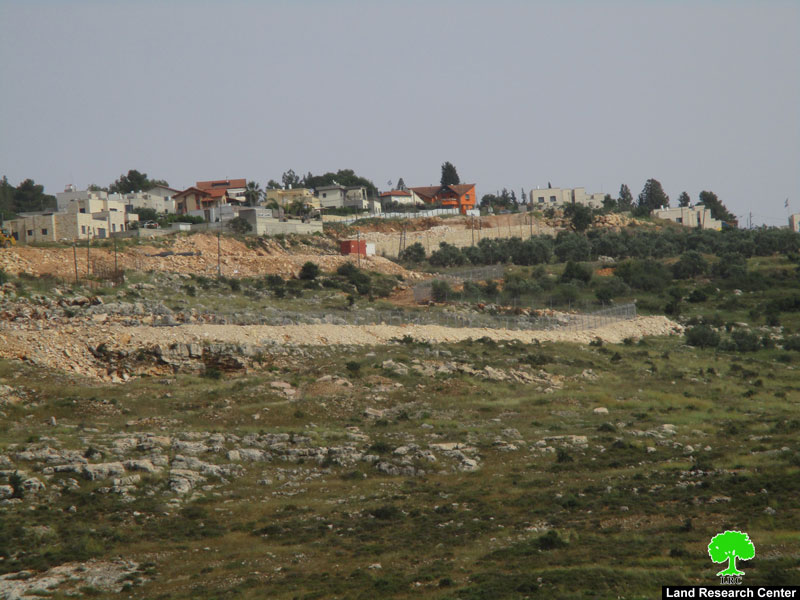
New Israeli scheme to expand “Shaked” illegal settlement southwest Jenin over confiscated lands from Dhaher Al-Malih town, the mentioned town will now become an isolated area with the least of life possibilities.
In the beginning of march, the occupation’s vehicles carried out ravages to build a new segment of the Apartheid wall that surrounds “Shaked” illegal settlement, the mentioned vehicles are ravaging only few meters away from some houses in the village, the planned wall will divide the town into 2 parts, and the town’s graveyard and even destroy some graves, other than destroying the western road that connects the town to each other. Few days before the ravaging, Israeli surveying team belongs to the settlements’ council drew signs on the ground reveals their plan to change the whole area and build an apartheid wall.
 Photo 1: the signs of the surveying team.
 |
 |
 |
  |
||
Photos 2-6: ravages to build new segment of the apartheid wall around Shaked illegal colony.
Villager Sa’ed Al-Khatib is an eyewitness on the occupation’s violations, in times the world claims to eliminate racism and promoting human rights, and told LRC observer:
“According to the signs the planned wall is only two meters away from my house, in case the new wall segment is carried out my house will become exposed to Israeli assaults and may be targeted of demolition, the house is inhabited by my 9 family members,4 of them are children.
 Photo 7: Tora military checkpoint where Palestinian passersby are subjected
by Israeli assaults and humiliations.
Farmer Majed Al-Khatib sees this new wall segment as a new disaster that affects villagers lives, And told LRC observer:” I work in poultry husbandry, I own about 2000 birds, and support a family consists of 5 members 3 of them are children, if the new wall segment was conducted as planned my barn will be subjected to complete demolition as it lies in the way of the wall, which means that I will lose my only source of income for my family”.
Illegal plan:
Omar Al-Khatib head of Rural council in Dhaher Al- Malih told LRC observer:
“We observed on the ground, the occupation is ravaging agricultural lands of about (8 meters*2 kilometers) in the southwest side of the settlement, We called the governor’s office and the director of Palestinian cooperation office in Jenin governorate, number of Palestinian officials reached the area to the village isolated behind the apartheid wall since 2002, On the other side, Shaked’s mayor and head of Israeli colonial communities in the area reached the location, and after long discussion between the two parties, Shaked’s mayor claimed that the ravaging aims to fix the walls route around Shaked settlement to adjust with the Ministry of Interior’s organizing plan of the settlement. After long discussion it turned out that no official military-confiscation orders were served, but the new segment of the wall is nothing more than Shaked’s council decision”
Head of the rural council in Dhaher Al-Malih added:
We immediately hired Lawyer Tawfeeq Aj-Jabareen to follow up the case in the Israeli court, in March 04 The Israeli occupation Supreme court passed a precautionary order to stop the construction on the new segment until the court’s session in 26 April 2018 , when the court will decide the fate of the new wall.
 The court’s decree
About the effects of the new wall segment in Dhaher Al-Malih:
“ Field observation shows that 692 dunums will be subjected on route and behind the new planned wall segment, 51 of them belong to heirs of Abdullah Harz Allah from Ya’abud, 300 are green areas, 91 states property belong to the Hashemite kingdom coffers, the affected lands belong to the area known of “Qasr Al0-Shaikh” of pieces : 15, 10, 12, 13,14 of Ya’abud lands according to civil reports in the Israeli civil administration in “Beit El”.
Head of rural council in Dhaher Al-Malih confirmed that the planned wall segment threatens 5 houses and a farm in the town, other than ravaging the town’s northern and western roads, even the town’s grave yard will be subjected.

Photo 8: The route of the new wall segment close to Palestinians houses in Dhaher Al-Malih.
Dhaher Al-Maleh:
The town has the least of possibilities, Dhaher Al-Malih does not contain a mosque, health clinic , school , kindergarten or even a rural council place.
He added : “Dhaher Al-Malih’s lands are all classified area C according to Oslo convention, and has a population of 450 people in 44 families, The town has a total area of 1013 dunums within Yabud city lands, the occupation impose difficulties on villagers’ lives and obstructs any developmental projects. Moreover, the so called Israeli building and organizing committee tried to impose an organizational build up plan on about 52 dunums in summer of 2017, the proposed plan does not fulfill the town’s people need to develop and grow. Consequently, 25 families of the town had to move to nearby villages”.
He added: The town lacks basic life needs, there are 60 students in different educational stages have to go through Tora checkpoint east the isolated town where they head to their schools in Tora town in the eastern side from the western wall, same thing to the patients and argent humanitarian cases Dhaher Al-Malih lacks a public or ever private clinic, if one of the citizens needed a medical treatment they have to pass to Tora town or Jenin city through the mentioned check point, The mentioned checkpoint is only open between 6:30 am and 9:00 pm.
Shaked’s Industrial zone:
The industrial zone that is relative to Shaked colony is what makes it very special. The zone includes 9 factories of (leathers, iron, cardboard, plastic furniture, and other industries) and is located in the northeastern side of the colony.
This very area got best privileges as opposed to other peers behind the green line in terms of electricity and water supply, tax reduction, and open market, which in that sense served at the area’s prosperity, continuity, and sustainability.
 |
 |
 |
|
Photos 9-11: “Shaked” colonial industrial zone.

 Photos 12 +13: Land ravaging to expand “Shaked” industrial zone.
About Shaked:
Shaked Settlement was established in 1981 on lands of ‘Anin village. Today, the settlement occupies a total land area of 950 dunums of Anin village and is home to more than 686 Israeli settlers. Throughout the years of the Israeli occupation, several Israeli plans were deposited in the settlement of Shaked with the intention to expand it.
The Land Research Center
LRC