• About The Project
  • Palestine in Century
  • Selected Maps
  • Glossary
  • About ARIJ
  • About LRC
  • By Year
    • Case Studies By Year
    • Daily Report By Year
Friday, May 22, 2026
POICA
No Result
View All Result
  • Home
  • Settlements
    • New Israeli Settlements
    • Settlement Expansion
  • Israeli Violations
    • Agriculture
    • Confiscation
    • Demolition
    • Environment
    • Eviction of Palestinians
    • Settlers Attacks
  • Bypass Roads
  • Israeli Plans
  • Segregation
    • Checkpoints
    • Closure
    • Separation Plans
  • Military Orders
  • Reports
    • Daily Report
    • Monthly Report
    • Quarterly Report
No Result
View All Result
POICA
No Result
View All Result

Israeli Occupation Forces order pastoral reserve of eviction in Nablus city

August 10, 2017
in Military Orders
Israeli Occupation Forces order pastoral reserve of eviction in Nablus city


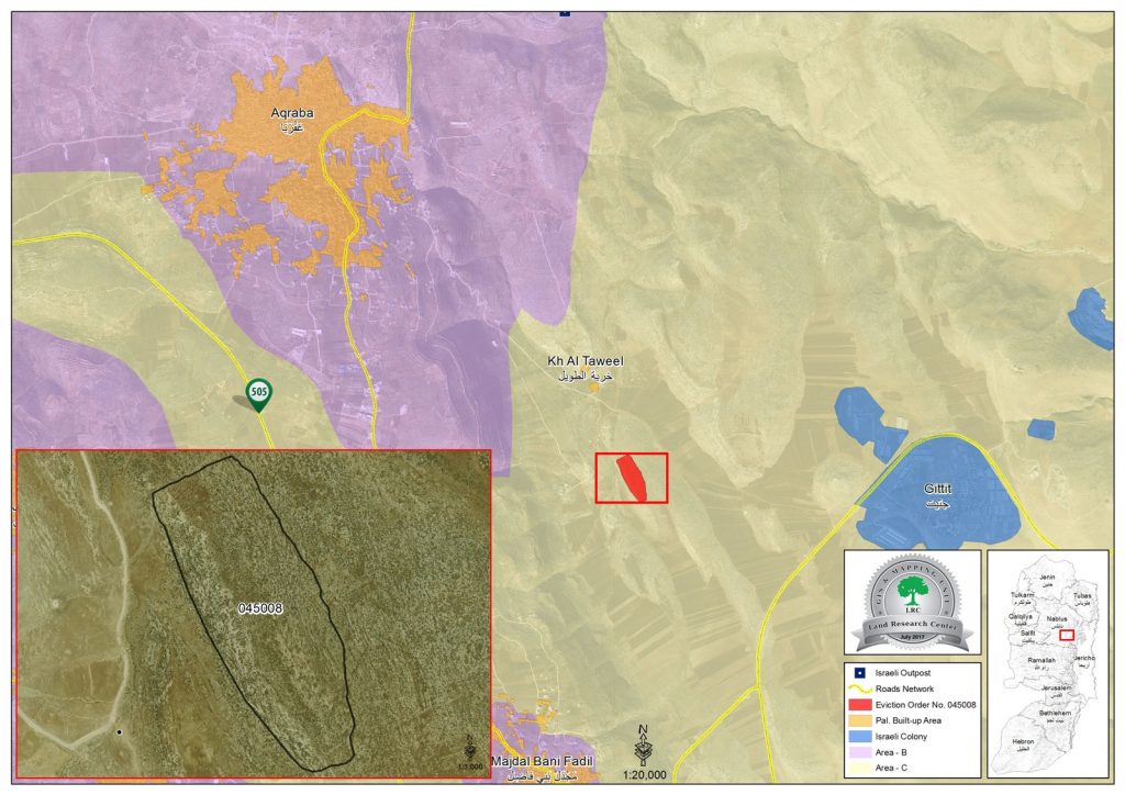
  • Violation: eviction order on a natural reserve
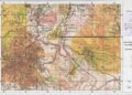
  • Location:  Tuwayyel hamlet- Nablus
  • Date:  July 09,2017
  • Perpetrators: Israeli Occupation Authorities
  • Victims: residents of the hamlet

Details:

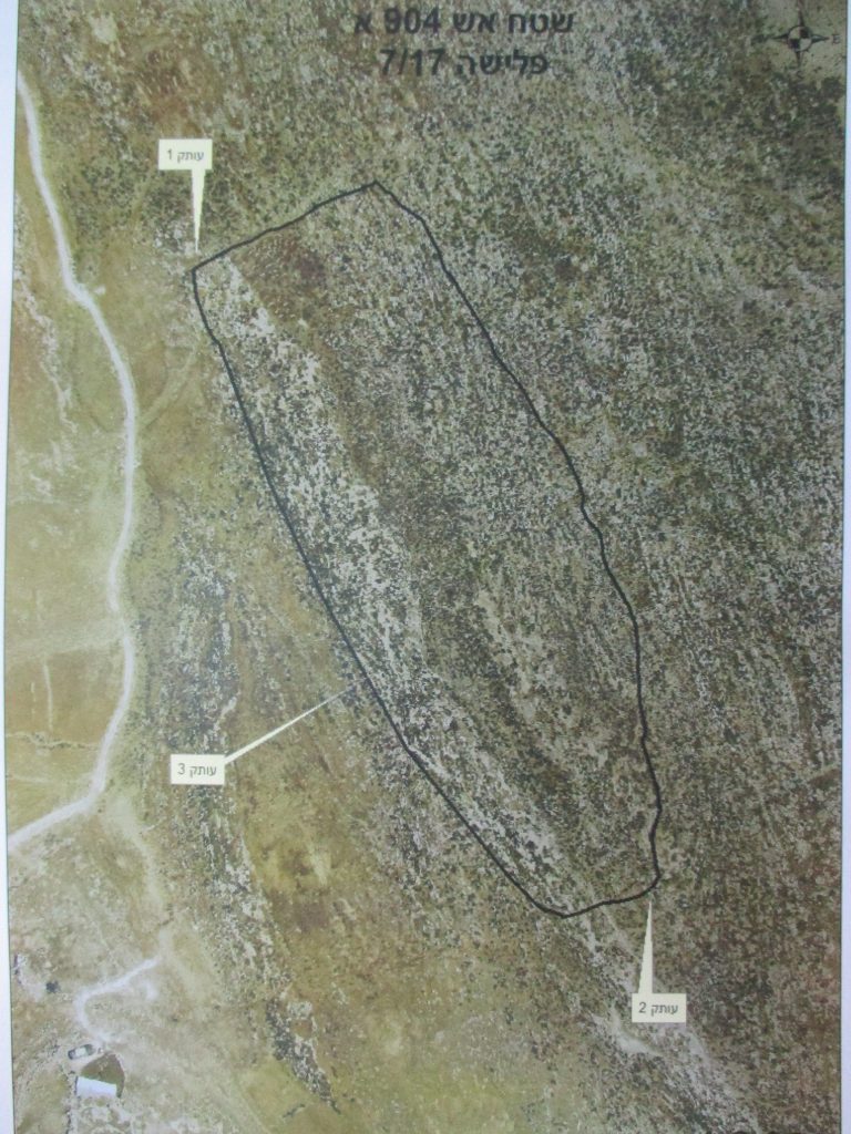
A force from Israel Civil Administration and the responsible of State Properties raided on July 09,2017 Khirbet Tuwayyel, east Aqraba town in Nablus governorate and hanged an eviction order on a natural reserve, targeting an area of 42 dunums on the claim of them being "state lands".

According to the order number 45008, the affected owners were given a 45 day deadline to completely evict the area and restore its previous status.

It should be noted that the reserve was implemented by Land Research Center and OXFAM with funds from Belgium Cooperation. It is a leading project that aims at preserving Palestinian lands and protect them from Israeli colonial expansionist plan. The reserve is reported to serve a number of farmers and herders in providing fodders for their sheep. Noteworthy, the project is intended to be implemented in different areas to reinforce the Palestinian resilience and steadfastness.

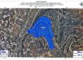
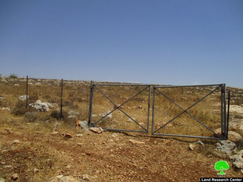
The natural reserve, 42 dunums, is surrounded by 1.5 m height fence and cultivated with 1200 seedlings of pastoral plants such like Akasia. The area also accommodates two water wells (110m3), which were also implemented by the project.

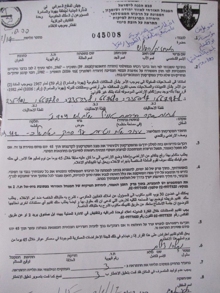
Photos 1-2: the eviction order


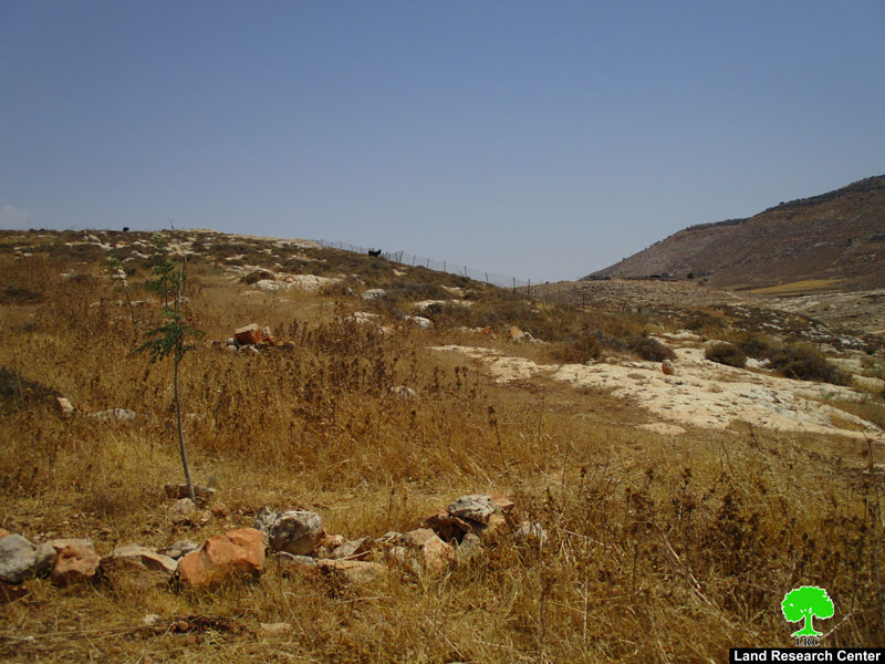
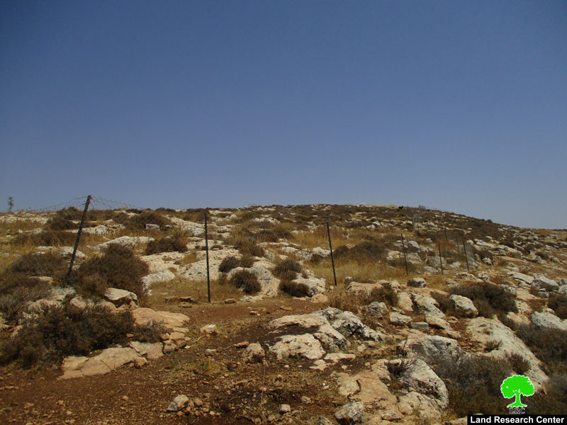
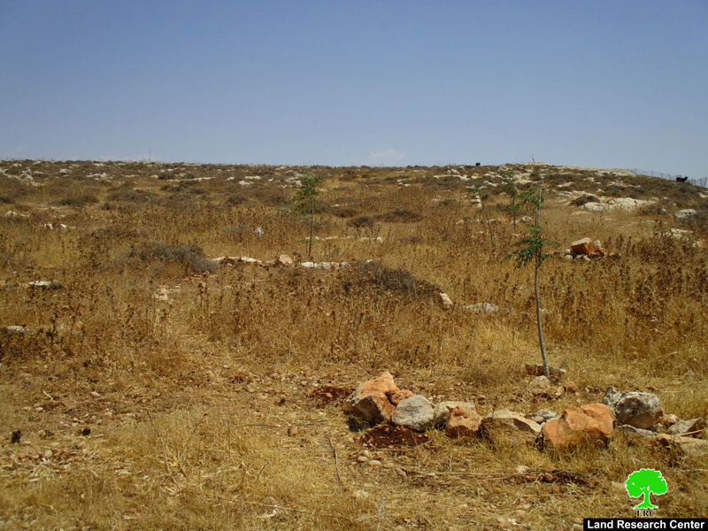
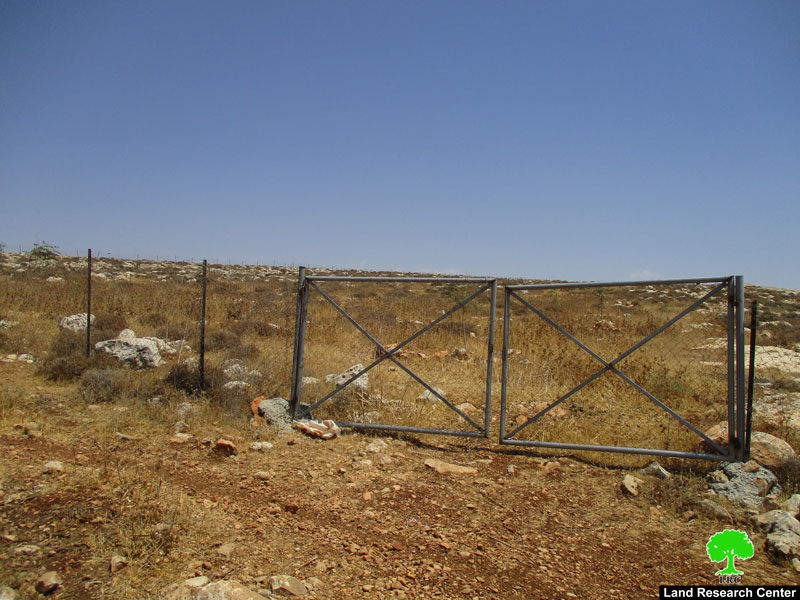
Photos 3-6: the targeted natural reserve


About al-Tuwayyel :

The hamlet has around 30000 agricultural and pastoral dunums , of which 8000 dunums are arid area,  15000 dunums are planted with field crops and 7000 dunums are subject to colonial expansion activities. (source: Aqraba village council).

A big part of the aforementioned lands is classified area B where  the major part is classified as C according to Oslo Accords.

 The rest of the lands is where the Israeli colonies of Jetit  ,Ma'ale  Efrayim  and Itamar extension are located.

  1. Jetit colony was established in 1973. It has a total  population of 191 by (2005) and a total land area of 1720 dunums. It is only 37km away from the green line of 1949 "the armistice line of 1949".
  2. Ma'ale Efrayim colony was established in 1970. It has a total population of 1423 by (2005) and a total land area of 4778 dunums.
  3. Itamar extension was established in 1984. It has a total population of 651 colonists by (2005) and a total land area of 7189 dunums; the colony is 28km away from the armistice line of 1949.


Prepared by
 The Land Research Center
LRC
 

Recommended For You

إقامة منطقة عسكرية عسكرية داخل أراضي (أ) في جنين

by arij
May 19, 2026
0
إقامة منطقة عسكرية عسكرية داخل أراضي (أ) في جنين

   في السابع من شهر أيار من العام 2026، وزعت سلطات الاحتلال الإسرائيلي أمرا عسكريا جديدة على أهالي مدينة جنين يقضي بمصادرة 7.2 دونما من الأراضي الفلسطينية في...

Read moreDetails

“بمساحة اجمالية 177 دونما من أرضي البيرة وبيتين”, طريق استيطاني لخدمة البؤر الاستيطانية في محافظة رام الله

by arij
May 18, 2026
0
“بمساحة اجمالية 177 دونما من أرضي البيرة وبيتين”, طريق استيطاني لخدمة البؤر الاستيطانية في محافظة رام الله

في الحادي عشر من شهر أيار من العام 2026, نشرت دائرة أراضي إسرائيل اعلانا جديدا يقضي بمصادرة المزيد من الأراضي الفلسطينية في محافظة رام الله لأغراض استيطانية في...

Read moreDetails

“في خدمة مستوطنة ناحال حيلتس”, طريق استيطاني إسرائيلي جديد على أراضي بتير وبيت جالا في محافظة بيت لحم

by arij
May 18, 2026
0
“في خدمة مستوطنة ناحال حيلتس”, طريق استيطاني إسرائيلي جديد على أراضي بتير وبيت جالا في محافظة بيت لحم

تواصل سلطات الاحتلال الإسرائيلي إحكام سيطرتها على المزيد من الأراضي الفلسطينية في الضفة الغربية المحتلة، وهذه المرة من خلال استهداف أراضي محافظة بيت لحم. ففي السادس والعشرين من...

Read moreDetails

مناطق نفوذ المستوطنات ودورها في إعادة تشكيل الجغرافيا الفلسطينية

by arij
April 23, 2026
0
مناطق نفوذ المستوطنات ودورها في إعادة تشكيل الجغرافيا الفلسطينية

أصدرت سلطات الاحتلال الإسرائيلي في العاشر من شهر نيسان 2026 الكراسة رقم (273)، وهي وثيقة تضم مجموعة من المناشير والأوامر والتعيينات الإسرائيلية المتعلقة بالجوانب الأمنية والعسكرية والإدارية، إضافة...

Read moreDetails

INFOGRAPHIC: Mapping Control – Israeli Militray Orders across the occupied West Bank – 2025

by arij
April 16, 2026
0

    Prepared by:   The Applied Research Institute – Jerusalem

Read moreDetails
Next Post
إخطار بإخلاء خمسة محميات رعوية في خربة طانا بمحافظة نابلس

إخطار بإخلاء خمسة محميات رعوية في خربة طانا بمحافظة نابلس

LATEST NEWS

إقامة منطقة عسكرية عسكرية داخل أراضي (أ) في جنين

إقامة منطقة عسكرية عسكرية داخل أراضي (أ) في جنين

by arij
May 19, 2026
0

........................................................

النكبة الفلسطينية في ذكراها الثامنة والسبعين: من التطهير العرقي إلى الإبادة وإعادة هندسة الجغرافيا الفلسطينية 

النكبة الفلسطينية في ذكراها الثامنة والسبعين: من التطهير العرقي إلى الإبادة وإعادة هندسة الجغرافيا الفلسطينية 

by arij
May 18, 2026
0

........................................................

“بمساحة اجمالية 177 دونما من أرضي البيرة وبيتين”, طريق استيطاني لخدمة البؤر الاستيطانية في محافظة رام الله

“بمساحة اجمالية 177 دونما من أرضي البيرة وبيتين”, طريق استيطاني لخدمة البؤر الاستيطانية في محافظة رام الله

by arij
May 18, 2026
0

........................................................

“في خدمة مستوطنة ناحال حيلتس”, طريق استيطاني إسرائيلي جديد على أراضي بتير وبيت جالا في محافظة بيت لحم

“في خدمة مستوطنة ناحال حيلتس”, طريق استيطاني إسرائيلي جديد على أراضي بتير وبيت جالا في محافظة بيت لحم

by arij
May 18, 2026
0

........................................................

flag_yellow_lowEU-PfP-Logo

This website and its content were initiated in 1993 by the Applied Research Institute – Jerusalem (ARIJ) and the Land Research Center (LRC) with the support from the European Union up until 2023. Since then, the Applied Research Institute – Jerusalem (ARIJ) has taken over the continued development and maintenance of the website. The views expressed remain solely those of ARIJ) and do not necessarily reflect those of the European Union.

© 2026 Copyright | ARIJ | All Rights reserved.

No Result
View All Result
  • Home
  • Settlements
    • New Israeli Settlements
    • Settlement Expansion
  • Israeli Violations
    • Agriculture
    • Confiscation
    • Demolition
    • Environment
    • Eviction of Palestinians
    • Settlers Attacks
  • Bypass Roads
  • Israeli Plans
  • Segregation
    • Checkpoints
    • Closure
    • Separation Plans
  • Military Orders
  • Reports
    • Daily Report
    • Monthly Report
    • Quarterly Report

© 2026 Copyright | ARIJ | All Rights reserved.