• About The Project
  • Palestine in Century
  • Selected Maps
  • Glossary
  • About ARIJ
  • About LRC
  • By Year
    • Case Studies By Year
    • Daily Report By Year
Friday, May 15, 2026
POICA
No Result
View All Result
  • Home
  • Settlements
    • New Israeli Settlements
    • Settlement Expansion
  • Israeli Violations
    • Agriculture
    • Confiscation
    • Demolition
    • Environment
    • Eviction of Palestinians
    • Settlers Attacks
  • Bypass Roads
  • Israeli Plans
  • Segregation
    • Checkpoints
    • Closure
    • Separation Plans
  • Military Orders
  • Reports
    • Daily Report
    • Monthly Report
    • Quarterly Report
No Result
View All Result
POICA
No Result
View All Result

Israel to continue a land grab on 142 dunums in Tulkarm

September 5, 2017
in Military Orders
إخطار باستمرار وضع اليد على 142 دونماً في منطقة الشعراويه شمال طولكرم


  • Violation: land expropriation order
  • Location: Al- Sha'rawyeh area- Tulkarm governorate
  • Date: December 31, 2016
  • Perpetrators: Israeli Occupation Forces
  • Victims: farmers of the area

Details:

Israel Army Commander in the West Bank, Roni ALov, issued a military order number (T/36/03), which states continuation on a 142.2 dunum land grab in Al- Sha'rawyeh area, north Tulkarm governorate on the claim of "establishing new segment of the wall".

The order entitles the Israeli Occupation Forces to continue the seizure of the targeted lands until 2019.

The chairman of the areas Joint Service Council said that the occupation intended to leave the order by one of the wall's agricultural gates without attaching any explanatory map to create a state of ambiguity.

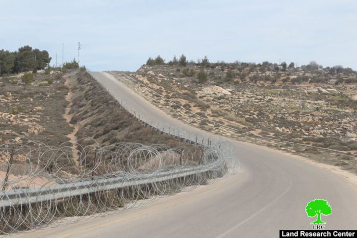
Photo 1: the apartheid wall established on Qaffin lands in Tulkarm


The targeted lands were reported to be located within the natural blocks number 3 from Zeita village, number 4 from Alar village, number 4 from Baqa Al-Sharqiya village, number 2 from Nazlit Isa village and number 2 from Qaffin lands.

It should be noted that the order targeted some parts from the occupied territories of 1948, especially in the natural blocks number 3 from Baqa Al-Gharbiya village and number 3 from Jit village.

It is reported that the targeted lands were confiscated in 2003 for the purpose of establishing the apartheid wall in the area.


Prepared by
 The Land Research Center
LRC
 

Recommended For You

مناطق نفوذ المستوطنات ودورها في إعادة تشكيل الجغرافيا الفلسطينية

by arij
April 23, 2026
0
مناطق نفوذ المستوطنات ودورها في إعادة تشكيل الجغرافيا الفلسطينية

أصدرت سلطات الاحتلال الإسرائيلي في العاشر من شهر نيسان 2026 الكراسة رقم (273)، وهي وثيقة تضم مجموعة من المناشير والأوامر والتعيينات الإسرائيلية المتعلقة بالجوانب الأمنية والعسكرية والإدارية، إضافة...

Read moreDetails

INFOGRAPHIC: Mapping Control – Israeli Militray Orders across the occupied West Bank – 2025

by arij
April 16, 2026
0

    Prepared by:   The Applied Research Institute – Jerusalem

Read moreDetails

سلطات الاحتلال الإسرائيلي تستهدف قرية الجيب بأمر عسكري جديد

by arij
March 17, 2026
0
سلطات الاحتلال الإسرائيلي تستهدف قرية الجيب بأمر عسكري جديد

نشر المسؤول عن الأملاك الحكومية وأملاك الغائبين في الإدارة المدنية الإسرائيلية في الحادي عشر من شهر اذار من العام 2026 اعلاننا مفاده نية ما يسمى " المسؤول عن...

Read moreDetails

سلطات الاحتلال الإسرائيلي تستخدم الأوامر العسكرية لتعمق المشروع الاستيطاني في الضفة الغربية المحتلة

by arij
February 26, 2026
0
سلطات الاحتلال الإسرائيلي تستخدم الأوامر العسكرية لتعمق المشروع الاستيطاني في الضفة الغربية المحتلة

تقديم منذ احتلال الضفة الغربية عام 1967، اعتمدت سلطات الاحتلال الإسرائيلي منهجية واسعة عبر استخدام الأوامر العسكرية كأداة "قانونية" لفرض الوقائع الجغرافية والديموغرافية على الأرض الفلسطينية. وأصبحت هذه...

Read moreDetails

بين مطرقة الأوامر العسكرية وسندان التقييد الجغرافي, أوامر عسكرية إسرائيلية جديدة تطال أكثر من 1000 دونم في طوباس

by arij
November 26, 2025
0
بين مطرقة الأوامر العسكرية وسندان التقييد الجغرافي, أوامر عسكرية إسرائيلية جديدة تطال أكثر من 1000 دونم في طوباس

في الحادي والعشرين من شهر تشرين الأول لعام 2025، تسلّم أهالي محافظة طوباس سلسلة من الأوامر العسكرية الإسرائيلية التي استهدفت مساحات واسعة من الأراضي الفلسطينية في المحافظة. وقد...

Read moreDetails
Next Post
الاحتلال يضع أسلاكاً شائكة حول الأراضي المحاذية لمستعمرة “افرات” في قرية واد رحال/ محافظة بيت لحم

Israeli Occupation Forces fence lands nearby Efrat colony in Bethlehem

LATEST NEWS

بين قصرة وترمسعيا: العنف الاستيطاني الاسرائيلي يضرب المجتمع الفلسطيني

by arij
May 6, 2026
0

........................................................

مناطق نفوذ المستوطنات ودورها في إعادة تشكيل الجغرافيا الفلسطينية

مناطق نفوذ المستوطنات ودورها في إعادة تشكيل الجغرافيا الفلسطينية

by arij
April 23, 2026
0

........................................................

التمدد الاستيطاني الإسرائيلي في الضفة الغربية المحتلة وأثره في تقويض مقومات الدولة الفلسطينية

التمدد الاستيطاني الإسرائيلي في الضفة الغربية المحتلة وأثره في تقويض مقومات الدولة الفلسطينية

by arij
April 16, 2026
0

........................................................

INFOGRAPHIC: ISRAELI SETTLER VIOLENCE IN 2025

by arij
April 16, 2026
0

........................................................

flag_yellow_lowEU-PfP-Logo

This website and its content were initiated in 1993 by the Applied Research Institute – Jerusalem (ARIJ) and the Land Research Center (LRC) with the support from the European Union up until 2023. Since then, the Applied Research Institute – Jerusalem (ARIJ) has taken over the continued development and maintenance of the website. The views expressed remain solely those of ARIJ) and do not necessarily reflect those of the European Union.

© 2026 Copyright | ARIJ | All Rights reserved.

No Result
View All Result
  • Home
  • Settlements
    • New Israeli Settlements
    • Settlement Expansion
  • Israeli Violations
    • Agriculture
    • Confiscation
    • Demolition
    • Environment
    • Eviction of Palestinians
    • Settlers Attacks
  • Bypass Roads
  • Israeli Plans
  • Segregation
    • Checkpoints
    • Closure
    • Separation Plans
  • Military Orders
  • Reports
    • Daily Report
    • Monthly Report
    • Quarterly Report

© 2026 Copyright | ARIJ | All Rights reserved.