• About The Project
  • Palestine in Century
  • Selected Maps
  • Glossary
  • About ARIJ
  • About LRC
  • By Year
    • Case Studies By Year
    • Daily Report By Year
Monday, June 29, 2026
POICA
No Result
View All Result
  • Home
  • Settlements
    • New Israeli Settlements
    • Settlement Expansion
  • Israeli Violations
    • Agriculture
    • Confiscation
    • Demolition
    • Environment
    • Eviction of Palestinians
    • Settlers Attacks
  • Bypass Roads
  • Israeli Plans
  • Segregation
    • Checkpoints
    • Closure
    • Separation Plans
  • Military Orders
  • Reports
    • Daily Report
    • Monthly Report
    • Quarterly Report
No Result
View All Result
POICA
No Result
View All Result

Israel issues an extension order on a land grab in Nablus

March 6, 2017
in Military Orders
إخطارات بتمديد سريان وضع اليد على أراض جنوب مدينة نابلس


  • Violation: extending the validity of a land grab order
  • Location:  Asira Al-Qibliya, Beita and Qabalan villages -Nablus city
  • Date: December 24, 2016
  • Perpetrators: Israeli Occupation Forces
  • Victims:  residents of the village

Details:

The so-called Israel Commander of Army in the West Bank, Roni ALov issued on December 24, 2016 a military order under the number (T/58/06) to extend the validity of confiscation on 4.5 dunum from the lands of Beita and Qabalan villages, south Nablus city. Noteworthy, the targeted area was confiscated in 2006 under the claim of "security reasons".

According to readings of the data of Geographical information system GIS department at Land Research Center for the attached map to the order, the actual area of targeted lands totals15.5 dunums

The targeted lands were identified in the natural bloc no. 5 from the locations of Al-Muntar and Al-Irn, natural block no.6 from the location of Al-Safih from Qabalan village.

Some parts of the targeted lands are founded within the natural block number 1 from Beita village.

According to the field follow-up on the location, the targeted lands were taken to establish a "buffer zone" on both sides of the bypass road number 55.


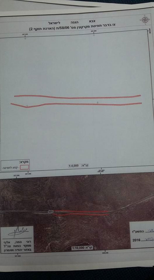
Photos 1-4: the military order of land grab

Photo 5: the location of targeted lands


Confiscation of 3.76 dunums from Qabalan village:

The Israel Commander of Army also issued the military order number T-59-06 stating a land grab on 3.76 dunums from Qabalan village; more specifically within the natural block number 6.

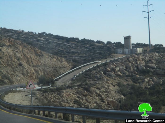
According to the order, the occupation gave itself the right to control the lands, which are located nearby the bypass road 55, where the occupation set up a watchtower.


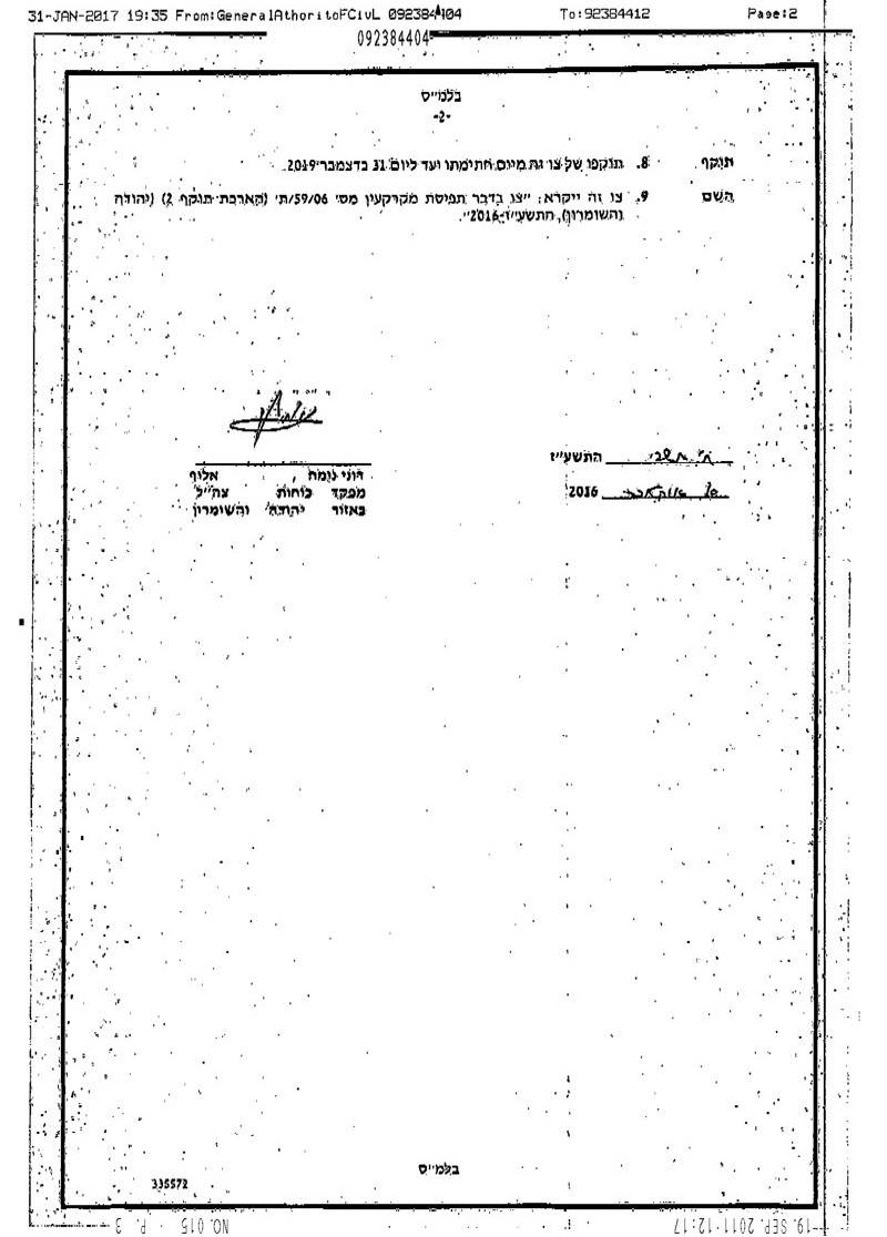
Photos 6-8: the military order of land grab

Photo 9: the military watchtower


Qabalan village:

Located 20 kilometer south of Nablus, Qabalan village is surrounded by Beita and Osin villages from north, Yatma village from west, Jurish and Aqraba villages from east and Talfit and Al-Sawiya village from the south.

Qabalan has a population of 7130( census of 2007). It has a total area of 10546 dunums, 1190 of which are built-up area.

Bypasses number 505 devoured more than 396 dunums from Qabalan village for its construction.

According to Oslo Accords, the lands of Qabalan are classified as follows:

  • Area B (7080) dunums (67%)
  • Area C (3467) dunums (33%)

Land grab in Asira Al-Qibliya :

The so-called Israel Commander of Army in the West Bank, Roni ALov, issued on January 24, 2017 a military order under the number (T/25/12) to confiscate 7 dunums from the lands of Asira Al-Qibliya village.

It should be reported that the area was served an order starting extension of validity on 3.9  dunum land grab  on January 2017 on the claim of "security reasons".


Photos 10-13: the land grab order number(T/25/12)

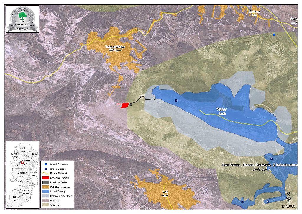
Photo 14: an aerial photo illustrating the recently confiscated lands ( in red color)
and the previous confiscation site ( in black color)


About 'Asira al Qibliya:

13 km west south of Nablus, 'Asira al Qibliya is surrounded by Tell village from the north/ Zeita and Jama'in from the west/ Madama and Yitzhar colony from the east/ 'Urif from the south. 'Asira al Qibliya has a population of 2366 people according to a 2007 census. It has a total area of 6440 dunums, 322 of which are built-up area.

International laws and covenants on violating lands and natural resources:

  1. International Covenant on Civil and Political Rights, Article 2 stated the following:

All peoples may, for their own ends, freely dispose of their natural wealth and resources without prejudice to any obligations arising out of international economic co-operation, based upon the principle of mutual benefit, and international law. In no case may a people be deprived of its own means of subsistence.

2.Universal Declaration of Human Rights, Article 17 stated the following:

  •  (1) Everyone has the right to own property alone as well as in association with others.

(2) No one shall be arbitrarily deprived of his property


Prepared by
 The Land Research Center
LRC
 

Recommended For You

الاحتلال الاسرائيلي يوسع سيطرته على أراضي جبل الفرديس بمصادرة 317 دونم اخرى

by arij
June 15, 2026
0
الاحتلال الاسرائيلي يوسع سيطرته على أراضي جبل الفرديس بمصادرة 317 دونم اخرى

  في الخامس والعشرين من شهر ايار من العام 2026 نشرط سلطات الاحتلال الاسرائيلي امرا عسكريا جديدا يحمل اسم "أمر بشأن قانون الأراضي استملاك للمصلحة العامة) (يهودا والسامرة)...

Read moreDetails

بواقع 19 دونما – سلسلة من الأوامر العسكري الإسرائيلي تستهدف أراضي محافظة بيت لحم بذريعة الأغراض العسكرية

by arij
June 13, 2026
0
بواقع 19 دونما – سلسلة من الأوامر العسكري الإسرائيلي تستهدف أراضي محافظة بيت لحم بذريعة الأغراض العسكرية

سلمت سلطات الاحتلال الإسرائيلي أهالي محافظة بيت لحم سلسلة من الأوامر العسكرية لمصادرة مساحات شاسعة من الأراضي الفلسطينية في المحافظة بذريعة أغراض عسكرية. واستهدفت الأوامر العسكرية الجديدة عددا...

Read moreDetails

بمساحة اجمالية بلغت 208 دونما – سلطات الاحتلال الإسرائيلي تصادر الاراضي في محافظة طوباس لصالح معسكر اسرائيلي

by arij
June 13, 2026
0
بمساحة اجمالية بلغت 208 دونما – سلطات الاحتلال الإسرائيلي تصادر الاراضي في محافظة طوباس لصالح معسكر اسرائيلي

سلّمت سلطات الاحتلال الإسرائيلي، في السابع من حزيران 2026، أهالي مدينة طوباس شمال الضفة الغربية المحتلة أمراً عسكرياً جديداً بعنوان: "أمر بشأن وضع اليد على أراضٍ رقم 79/26/ت...

Read moreDetails

الاحتلال يرسّخ بؤرة “يتسيف” الاستيطانية عبر تخصيص 92 دونماً من أراضي بيت ساحور

by arij
June 9, 2026
0
الاحتلال يرسّخ بؤرة “يتسيف” الاستيطانية عبر تخصيص 92 دونماً من أراضي بيت ساحور

أصدر جيش الاحتلال الإسرائيلي في الخامس من شهر اذار من العام 2026 إعلاناً عسكرياً جديداً موقع من قبل ما يُسمّى بـ “قائد قوات جيش الدفاع الإسرائيلي في منطقة...

Read moreDetails

كراسة أوامر إسرائيلية جديدة تمهد لمصادرة أكثر من 20 ألف دونم في الضفة الغربية المحتلة

by arij
June 9, 2026
0
كراسة أوامر إسرائيلية جديدة تمهد لمصادرة أكثر من 20 ألف دونم في الضفة الغربية المحتلة

في الخامس من شهر اذار من العام 2026، أصدرت سلطات الاحتلال الإسرائيلي كراسة جديدة من الأوامر العسكرية التي تهدف إلى توسيع نطاق النشاطات الاستيطانية على الأراضي الفلسطينية، وذلك...

Read moreDetails
Next Post
الشروع في شق طريق استعماري جديد حول مستعمرة ” افني حيفتس” على حساب أراضي قرية شوفة

Final stop-work orders on four residences in the Hebron town of Beit Awwa

LATEST NEWS

الاحتلال الاسرائيلي يوسع سيطرته على أراضي جبل الفرديس بمصادرة 317 دونم اخرى

الاحتلال الاسرائيلي يوسع سيطرته على أراضي جبل الفرديس بمصادرة 317 دونم اخرى

by arij
June 15, 2026
0

........................................................

بواقع 19 دونما – سلسلة من الأوامر العسكري الإسرائيلي تستهدف أراضي محافظة بيت لحم بذريعة الأغراض العسكرية

بواقع 19 دونما – سلسلة من الأوامر العسكري الإسرائيلي تستهدف أراضي محافظة بيت لحم بذريعة الأغراض العسكرية

by arij
June 13, 2026
0

........................................................

بمساحة اجمالية بلغت 208 دونما – سلطات الاحتلال الإسرائيلي تصادر الاراضي في محافظة طوباس لصالح معسكر اسرائيلي

بمساحة اجمالية بلغت 208 دونما – سلطات الاحتلال الإسرائيلي تصادر الاراضي في محافظة طوباس لصالح معسكر اسرائيلي

by arij
June 13, 2026
0

........................................................

الاحتلال يرسّخ بؤرة “يتسيف” الاستيطانية عبر تخصيص 92 دونماً من أراضي بيت ساحور

الاحتلال يرسّخ بؤرة “يتسيف” الاستيطانية عبر تخصيص 92 دونماً من أراضي بيت ساحور

by arij
June 9, 2026
0

........................................................

flag_yellow_lowEU-PfP-Logo

This website and its content were initiated in 1993 by the Applied Research Institute – Jerusalem (ARIJ) and the Land Research Center (LRC) with the support from the European Union up until 2023. Since then, the Applied Research Institute – Jerusalem (ARIJ) has taken over the continued development and maintenance of the website. The views expressed remain solely those of ARIJ) and do not necessarily reflect those of the European Union.

© 2026 Copyright | ARIJ | All Rights reserved.

No Result
View All Result
  • Home
  • Settlements
    • New Israeli Settlements
    • Settlement Expansion
  • Israeli Violations
    • Agriculture
    • Confiscation
    • Demolition
    • Environment
    • Eviction of Palestinians
    • Settlers Attacks
  • Bypass Roads
  • Israeli Plans
  • Segregation
    • Checkpoints
    • Closure
    • Separation Plans
  • Military Orders
  • Reports
    • Daily Report
    • Monthly Report
    • Quarterly Report

© 2026 Copyright | ARIJ | All Rights reserved.