• About The Project
  • Palestine in Century
  • Selected Maps
  • Glossary
  • About ARIJ
  • About LRC
  • By Year
    • Case Studies By Year
    • Daily Report By Year
Friday, April 24, 2026
POICA
No Result
View All Result
  • Home
  • Settlements
    • New Israeli Settlements
    • Settlement Expansion
  • Israeli Violations
    • Agriculture
    • Confiscation
    • Demolition
    • Environment
    • Eviction of Palestinians
    • Settlers Attacks
  • Bypass Roads
  • Israeli Plans
  • Segregation
    • Checkpoints
    • Closure
    • Separation Plans
  • Military Orders
  • Reports
    • Daily Report
    • Monthly Report
    • Quarterly Report
No Result
View All Result
POICA
No Result
View All Result

Israel government issues eviction order on a natural reserve East Jerusalem

February 7, 2017
in Military Orders


  • Violation: eviction order on 202 dunums
  • Location:  Al-Muntar Bedouin community
  • Date:  December 29, 2016
  • Perpetrators: Israel Civil Administration
  • Victims:  owners of lands and residents of the community

Details:

A force from Israel Civil Administration raided on December 29, 2016 the natural reserve of Al-Muntar that is 9km away from Al-Sawahreh Al-Sharqiya village and hanged an eviction order on it.

The order, issued by the Central Inspection Unit – Israel Civil Administration,  ordered the reserve evicted and gave a 72 hour deadline to object to the order in the headquarter of Israel Civil Administration in Beit El colony. Noteworthy, the order was issued on Thursday December 29, 2016 leaving no time to object since the deadline will take place during the weekend and that the last day of the deadline is the new year.

12


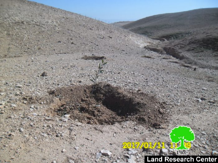
It should be noted that the order targeted the reserve implemented by Land Research Center and OXFAM with funds from Belgium Cooperation within the project entitled "" Integrated Protection in Area C: Enhancing the Resilience of Communities to Violations of International Humanitarian and Human Rights Law".

At time the order was issued, the project team sought attorney from Norwegian Refugee Council NRC to object to the order in order to protect the lands from being ravaged the seedling from being uprooted. All necessary legal papers were prepared by Al-Sawahreh Al-Sharqiya municipality, OXFAM and Land Research Center.

It should be noted that the community's school and clinic were targeted nine days ago. Noteworthy, the structures were still under construction. Also,  Israeli Occupation Forces targeted the community's natural reserve, where the force confiscated 2500 seedlings of Akasia trees.

34
56


mintar

Al-Muntar Bedouin community:

It is one of the Bedouin communities located in East Jerusalem; it has a total built-up area of 36 dunums. The community is inhabited by 68 families (470 members) who hail from the Bir Al-Saba' area, from which they were displaced in 1948. Residents of the area belong to four main clans namely (Hadhaleen, Hamadi, Krushan and Sawahrah). Metal slaps and barracks barracks are the common material of the people's residences. Residents of the community depend on livestock and poultry husbandry; they have 200 agricultural dunums where they plant wheat and barley.

Borders of the community:

Al-Muntar is edged by Arab Al-Jahaleen community from the east, Al-Sawahrah Al-Sharqiya village from the southwest and Abu Nuwwar community from the north. Noteworthy, the community lacks basic needs and services such like roads networks, transportation, electricity and access to health and education.


Prepared by
 The Land Research Center
LRC
 

Recommended For You

مناطق نفوذ المستوطنات ودورها في إعادة تشكيل الجغرافيا الفلسطينية

by arij
April 23, 2026
0
مناطق نفوذ المستوطنات ودورها في إعادة تشكيل الجغرافيا الفلسطينية

أصدرت سلطات الاحتلال الإسرائيلي في العاشر من شهر نيسان 2026 الكراسة رقم (273)، وهي وثيقة تضم مجموعة من المناشير والأوامر والتعيينات الإسرائيلية المتعلقة بالجوانب الأمنية والعسكرية والإدارية، إضافة...

Read moreDetails

INFOGRAPHIC: Mapping Control – Israeli Militray Orders across the occupied West Bank – 2025

by arij
April 16, 2026
0

    Prepared by:   The Applied Research Institute – Jerusalem

Read moreDetails

سلطات الاحتلال الإسرائيلي تستهدف قرية الجيب بأمر عسكري جديد

by arij
March 17, 2026
0
سلطات الاحتلال الإسرائيلي تستهدف قرية الجيب بأمر عسكري جديد

نشر المسؤول عن الأملاك الحكومية وأملاك الغائبين في الإدارة المدنية الإسرائيلية في الحادي عشر من شهر اذار من العام 2026 اعلاننا مفاده نية ما يسمى " المسؤول عن...

Read moreDetails

سلطات الاحتلال الإسرائيلي تستخدم الأوامر العسكرية لتعمق المشروع الاستيطاني في الضفة الغربية المحتلة

by arij
February 26, 2026
0
سلطات الاحتلال الإسرائيلي تستخدم الأوامر العسكرية لتعمق المشروع الاستيطاني في الضفة الغربية المحتلة

تقديم منذ احتلال الضفة الغربية عام 1967، اعتمدت سلطات الاحتلال الإسرائيلي منهجية واسعة عبر استخدام الأوامر العسكرية كأداة "قانونية" لفرض الوقائع الجغرافية والديموغرافية على الأرض الفلسطينية. وأصبحت هذه...

Read moreDetails

بين مطرقة الأوامر العسكرية وسندان التقييد الجغرافي, أوامر عسكرية إسرائيلية جديدة تطال أكثر من 1000 دونم في طوباس

by arij
November 26, 2025
0
بين مطرقة الأوامر العسكرية وسندان التقييد الجغرافي, أوامر عسكرية إسرائيلية جديدة تطال أكثر من 1000 دونم في طوباس

في الحادي والعشرين من شهر تشرين الأول لعام 2025، تسلّم أهالي محافظة طوباس سلسلة من الأوامر العسكرية الإسرائيلية التي استهدفت مساحات واسعة من الأراضي الفلسطينية في المحافظة. وقد...

Read moreDetails
Next Post
أمر بشأن الإخلاء لمحمية طبيعية قيد الإنشاء في تجمع بدوي المنطار بدو شرقي القدس

أمر بشأن الإخلاء لمحمية طبيعية قيد الإنشاء في تجمع بدوي المنطار بدو شرقي القدس

LATEST NEWS

مناطق نفوذ المستوطنات ودورها في إعادة تشكيل الجغرافيا الفلسطينية

مناطق نفوذ المستوطنات ودورها في إعادة تشكيل الجغرافيا الفلسطينية

by arij
April 23, 2026
0

........................................................

التمدد الاستيطاني الإسرائيلي في الضفة الغربية المحتلة وأثره في تقويض مقومات الدولة الفلسطينية

التمدد الاستيطاني الإسرائيلي في الضفة الغربية المحتلة وأثره في تقويض مقومات الدولة الفلسطينية

by arij
April 16, 2026
0

........................................................

INFOGRAPHIC: ISRAELI SETTLER VIOLENCE IN 2025

by arij
April 16, 2026
0

........................................................

العدالة المؤجلة ورأي بلا تنفيذ: من قرار المحكمة إلى واقع الضم

أدوات غير مباشرة للاستيطان الإسرائيلي في مناطق (أ) و(ب) لإعادة تشكيل الجغرافيا والسيطرة في الضفة الغربية   

by arij
April 16, 2026
0

........................................................

flag_yellow_lowEU-PfP-Logo

This website and its content were initiated in 1993 by the Applied Research Institute – Jerusalem (ARIJ) and the Land Research Center (LRC) with the support from the European Union up until 2023. Since then, the Applied Research Institute – Jerusalem (ARIJ) has taken over the continued development and maintenance of the website. The views expressed remain solely those of ARIJ) and do not necessarily reflect those of the European Union.

© 2026 Copyright | ARIJ | All Rights reserved.

No Result
View All Result
  • Home
  • Settlements
    • New Israeli Settlements
    • Settlement Expansion
  • Israeli Violations
    • Agriculture
    • Confiscation
    • Demolition
    • Environment
    • Eviction of Palestinians
    • Settlers Attacks
  • Bypass Roads
  • Israeli Plans
  • Segregation
    • Checkpoints
    • Closure
    • Separation Plans
  • Military Orders
  • Reports
    • Daily Report
    • Monthly Report
    • Quarterly Report

© 2026 Copyright | ARIJ | All Rights reserved.