• About The Project
  • Palestine in Century
  • Selected Maps
  • Glossary
  • About ARIJ
  • About LRC
  • By Year
    • Case Studies By Year
    • Daily Report By Year
Friday, May 1, 2026
POICA
No Result
View All Result
  • Home
  • Settlements
    • New Israeli Settlements
    • Settlement Expansion
  • Israeli Violations
    • Agriculture
    • Confiscation
    • Demolition
    • Environment
    • Eviction of Palestinians
    • Settlers Attacks
  • Bypass Roads
  • Israeli Plans
  • Segregation
    • Checkpoints
    • Closure
    • Separation Plans
  • Military Orders
  • Reports
    • Daily Report
    • Monthly Report
    • Quarterly Report
No Result
View All Result
POICA
No Result
View All Result

A Statement Released by Land Research Center in Commemoration of the Nakba

July 12, 2016
in Israeli Violations


In the anniversary of the Israeli occupation of the year 1967, Israeli violations against Lands and housing escalate

May 15, 2016 marked the 68th anniversary of the Palestinian Nakba "Catastrophe"  of 1967, during which the Israeli occupation displaced 750,000 Palestinians from 628 villages and cities. More than 500 Palestinian villages got defaced; residents of those villages were either internally displaced or became refugees in the nearby Arab countries (Lebanon Syria and Jordan). In that sense, Israel confiscated the properties of displaced Palestinians and gave the right to dispose such properties for foreign colonists.

The occupation didn’t stop  after the Nakba of  May 05, 1967, it further went to wage another war on June 05, 1967, which later was called Naksa or Six-Day War. As a result, the West Bank including East Jerusalem in addition to Gaza strip, Golan Heights and Sinai desert were occupied. Not only, the villages of northwest Jerusalem namely (Amoas, Beit Nuba and Yalu), Dung Gate and Al-Sharaf neighborhood were entirely demolished.

The Israeli occupation is seen to continue its policy of lands confiscation and indigenous displacement. It prohibits demographic expansion and housing in all Palestinian villages and cities classified as area "C" according to Oslo Accords.

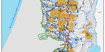
The successive governments of Israel, after the year 1967, put plans and laws that allowed the confiscation of private and public Palestinian properties in West Bank and East Jerusalem areas, the establishment of Israeli colonies and legalization of outposts. And to serve the colonization project, the occupation opened networks of bypass roads, established military camps and buffer zones for colonies, camps and watchtowers and built the apartheid wall. Not only, the occupation stole lands and gave them for colonists to benefit from and designed master plans for colonies to guarantee a massive takeover of lands. All this came to serve the colonization, which is now controlling 38.8% of the total land area of the West Bank (more than half of the lands classified as area "C" according to Oslo Accords). Noteworthy, this area is bigger in size than area "A" and "B" combined together (36.1%).

What remains of the total area of the West Bank is only 25.1% that colonists fight hard to seize to be used for colonial purposes .

It became clear that there is an Israeli escalation in imposing de facto on the ground. It is seen in the monthly rate of home demolition that reached up 17 residence during the past six year. In 2016, the rate of home demolition per month reached 47 residences.

As for structures, the rate of structures demolition during the past couple of years reached 33 structures while the rate of structures demolition in 201056 reached 78 structures.

Demolition orders served on structures and residences during May 2016 totaled 223 ones. With theses intimidating numbers, we are commemorating the war of June 1967, reminding ourselves that what has been occupied is now exploited by colonists.


Prepared by
 The Land Research Center
LRC
 

Recommended For You

INFOGRAPHIC: ISRAELI SETTLER VIOLENCE IN 2025

by arij
April 16, 2026
0

INFOGRAPHIC: ISRAELI SETTLER VIOLENCE IN 2025     Prepared by:   The Applied Research Institute – Jerusalem  

Read moreDetails

أدوات غير مباشرة للاستيطان الإسرائيلي في مناطق (أ) و(ب) لإعادة تشكيل الجغرافيا والسيطرة في الضفة الغربية   

by arij
April 16, 2026
0
العدالة المؤجلة ورأي بلا تنفيذ: من قرار المحكمة إلى واقع الضم

منذ توقيع اتفاقيات أوسلو في تسعينيات القرن الماضي، تم تقسيم الضفة الغربية إلى ثلاث مناطق إدارية وأمنية: (أ)، (ب)، و(ج)، بهدف تنظيم المرحلة الانتقالية نحو تسوية نهائية. وبموجب...

Read moreDetails

INFOGRAPHIC: Palestinian Trees – Victims of the Israeli occupation Army & Settler Groups in 2025

by arij
April 16, 2026
0

    INFOGRAPHIC: Palestinian Trees - Victims of the Israeli occupation Army & Settler Groups in 2025 Prepared by:   The Applied Research Institute – Jerusalem  

Read moreDetails

ذكرى الـ 50 ليوم الأرض: فلسطين بين ذاكرة الدم وصمود البقاء    

by arij
April 16, 2026
0

في الثلاثين من آذار، لا يستحضر يوم الأرض في الوعي الفلسطيني بوصفه مناسبة رمزية عابرة، بل كحدث تأسيسي متجدد يعكس استمرارية الصراع على الأرض والهوية. وبعد مرور خمسين...

Read moreDetails

الاحتلال الإسرائيلي يستهدف مشاريع تنموية في قرية جورة الشمعة جنوب شرق بيت لحم

by arij
March 14, 2026
0
الاحتلال الإسرائيلي يستهدف مشاريع تنموية في قرية جورة الشمعة جنوب شرق بيت لحم

في يوم الاربعاء الموافق الرابع من شهر اذار من العام من العام 2026, سلمت سلطات الاحتلال الاسرائيلي (الإدارة المدنية الاسرائيلية) أهالي قرية جورة الشمعة جنوب شرق مدينة بيت...

Read moreDetails
Next Post
في الذكرى ال49 لإحتلال مدينة القدس, مستوطنون ينظمون مسيرة الأعلام السنوية التي يحتفلون فيها بذكرى ما يسمونها “بتوحيد القدس”

في الذكرى ال49 لإحتلال مدينة القدس, مستوطنون ينظمون مسيرة الأعلام السنوية التي يحتفلون فيها بذكرى ما يسمونها "بتوحيد القدس"

LATEST NEWS

مناطق نفوذ المستوطنات ودورها في إعادة تشكيل الجغرافيا الفلسطينية

مناطق نفوذ المستوطنات ودورها في إعادة تشكيل الجغرافيا الفلسطينية

by arij
April 23, 2026
0

........................................................

التمدد الاستيطاني الإسرائيلي في الضفة الغربية المحتلة وأثره في تقويض مقومات الدولة الفلسطينية

التمدد الاستيطاني الإسرائيلي في الضفة الغربية المحتلة وأثره في تقويض مقومات الدولة الفلسطينية

by arij
April 16, 2026
0

........................................................

INFOGRAPHIC: ISRAELI SETTLER VIOLENCE IN 2025

by arij
April 16, 2026
0

........................................................

العدالة المؤجلة ورأي بلا تنفيذ: من قرار المحكمة إلى واقع الضم

أدوات غير مباشرة للاستيطان الإسرائيلي في مناطق (أ) و(ب) لإعادة تشكيل الجغرافيا والسيطرة في الضفة الغربية   

by arij
April 16, 2026
0

........................................................

flag_yellow_lowEU-PfP-Logo

This website and its content were initiated in 1993 by the Applied Research Institute – Jerusalem (ARIJ) and the Land Research Center (LRC) with the support from the European Union up until 2023. Since then, the Applied Research Institute – Jerusalem (ARIJ) has taken over the continued development and maintenance of the website. The views expressed remain solely those of ARIJ) and do not necessarily reflect those of the European Union.

© 2026 Copyright | ARIJ | All Rights reserved.

No Result
View All Result
  • Home
  • Settlements
    • New Israeli Settlements
    • Settlement Expansion
  • Israeli Violations
    • Agriculture
    • Confiscation
    • Demolition
    • Environment
    • Eviction of Palestinians
    • Settlers Attacks
  • Bypass Roads
  • Israeli Plans
  • Segregation
    • Checkpoints
    • Closure
    • Separation Plans
  • Military Orders
  • Reports
    • Daily Report
    • Monthly Report
    • Quarterly Report

© 2026 Copyright | ARIJ | All Rights reserved.