• About The Project
  • Palestine in Century
  • Selected Maps
  • Glossary
  • About ARIJ
  • About LRC
  • By Year
    • Case Studies By Year
    • Daily Report By Year
Monday, June 22, 2026
POICA
No Result
View All Result
  • Home
  • Settlements
    • New Israeli Settlements
    • Settlement Expansion
  • Israeli Violations
    • Agriculture
    • Confiscation
    • Demolition
    • Environment
    • Eviction of Palestinians
    • Settlers Attacks
  • Bypass Roads
  • Israeli Plans
  • Segregation
    • Checkpoints
    • Closure
    • Separation Plans
  • Military Orders
  • Reports
    • Daily Report
    • Monthly Report
    • Quarterly Report
No Result
View All Result
POICA
No Result
View All Result

Military Observation Tent installed on Al-Khader Town lands

May 23, 2016
in Israeli Violations
Military Observation Tent installed on Al-Khader Town lands

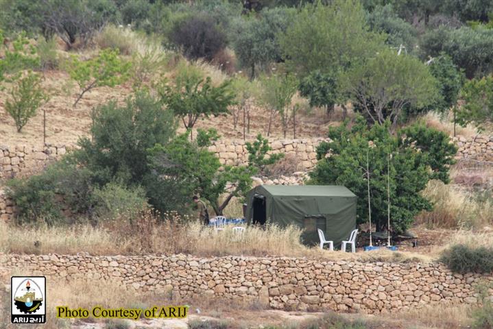
On May 22, 2016, the Israeli Army Forces installed a military tent north of Al-Khader town northwest of Bethlehem Governorate. The military observation tent installed to the western part of the Wall and the Israeli bypass road # 60 and confronting Al-Mardares neighborhood in  the town of Al-Khader. See the pictures below:

Photos for the military tent in AL-Khader captured by ARIJ fieldworkers


As a matter of fact , the Israeli installation of the aforementioned  military tent came for observing the Palestinian students in Al-Madares neighborhood in AL-Khader ,where the Israeli soldiers may open fire on the students under the pretext of throwing stones on the Israeli cars traveling on the Israeli bypass road No.60. 

It’s worth pointed that On the early morning of May, 17, 2016, the Israeli Army bulldozers protected by Israeli Occupation Forces stationed in Al-Mardares neighborhood northwest of Al-Khader town and started razing a piece of land in the neighborhood. The (1.7 dunums -1700 m2  Islamic Waqf owned land ) located nearby the school complex in the neighborhood. For more details refer for the previously written case study: (“For Security Purposes… The Israeli Bulldozers razed about 2 dunums of Lads in Al-Khader town northwest of Bethlehem Governorate).

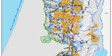
Al-Khader town, a Palestinian community located some 4.5 kilometers east of Bethlehem city.  It is bordered by Husan and Battir villages from the west and northwest, Al Doha and Beit Jala cities from the north and northeast, and Al Duheisha Refugee camp and Artas village from the south. The built-up area of Al- Khader village spreads on 601 dunums of land, about 3% of the village's total land area (20,090 dunums). The village is a home to 11,062 inhabitants (PCBS 2012), most of who work in the agriculture sector. The village's rich fertile soil has made farming and agriculture feasible on the land; therefore, agriculture has been and is still considered the major source of income for many families of the village.

Prepared By  
The Applied Research Institute – Jerusalem
ARIJ

Recommended For You

النكبة الفلسطينية في ذكراها الثامنة والسبعين: من التطهير العرقي إلى الإبادة وإعادة هندسة الجغرافيا الفلسطينية 

by arij
May 18, 2026
0
النكبة الفلسطينية في ذكراها الثامنة والسبعين: من التطهير العرقي إلى الإبادة وإعادة هندسة الجغرافيا الفلسطينية 

تحل الذكرى الثامنة والسبعون للنكبة الفلسطينية في ظل واحدة من أكثر المراحل دموية وخطورة في التاريخ الفلسطيني المعاصر، حيث تتداخل آثار النكبة الأصلية لعام 1948 مع واقع الحرب...

Read moreDetails

بين قصرة وترمسعيا: العنف الاستيطاني الاسرائيلي يضرب المجتمع الفلسطيني

by arij
May 6, 2026
0

في الثالث من شهر أيار من العام 2026، شهد مزارعون في عدة قرى في الضفة الغربية المحتلة على مشهد بات مألوفًا وقاسيا في آنٍ واحد: أشجار مثمرة مقطوعة...

Read moreDetails

INFOGRAPHIC: ISRAELI SETTLER VIOLENCE IN 2025

by arij
April 16, 2026
0

INFOGRAPHIC: ISRAELI SETTLER VIOLENCE IN 2025     Prepared by:   The Applied Research Institute – Jerusalem  

Read moreDetails

أدوات غير مباشرة للاستيطان الإسرائيلي في مناطق (أ) و(ب) لإعادة تشكيل الجغرافيا والسيطرة في الضفة الغربية   

by arij
April 16, 2026
0
العدالة المؤجلة ورأي بلا تنفيذ: من قرار المحكمة إلى واقع الضم

منذ توقيع اتفاقيات أوسلو في تسعينيات القرن الماضي، تم تقسيم الضفة الغربية إلى ثلاث مناطق إدارية وأمنية: (أ)، (ب)، و(ج)، بهدف تنظيم المرحلة الانتقالية نحو تسوية نهائية. وبموجب...

Read moreDetails

INFOGRAPHIC: Palestinian Trees – Victims of the Israeli occupation Army & Settler Groups in 2025

by arij
April 16, 2026
0

    INFOGRAPHIC: Palestinian Trees - Victims of the Israeli occupation Army & Settler Groups in 2025 Prepared by:   The Applied Research Institute – Jerusalem  

Read moreDetails
Next Post
Announcement of changing land status from Agricultural to construction in Talmon Settlement

Announcement of changing land status from Agricultural to construction in Talmon Settlement

LATEST NEWS

الاحتلال الاسرائيلي يوسع سيطرته على أراضي جبل الفرديس بمصادرة 317 دونم اخرى

الاحتلال الاسرائيلي يوسع سيطرته على أراضي جبل الفرديس بمصادرة 317 دونم اخرى

by arij
June 15, 2026
0

........................................................

بواقع 19 دونما – سلسلة من الأوامر العسكري الإسرائيلي تستهدف أراضي محافظة بيت لحم بذريعة الأغراض العسكرية

بواقع 19 دونما – سلسلة من الأوامر العسكري الإسرائيلي تستهدف أراضي محافظة بيت لحم بذريعة الأغراض العسكرية

by arij
June 13, 2026
0

........................................................

بمساحة اجمالية بلغت 208 دونما – سلطات الاحتلال الإسرائيلي تصادر الاراضي في محافظة طوباس لصالح معسكر اسرائيلي

بمساحة اجمالية بلغت 208 دونما – سلطات الاحتلال الإسرائيلي تصادر الاراضي في محافظة طوباس لصالح معسكر اسرائيلي

by arij
June 13, 2026
0

........................................................

الاحتلال يرسّخ بؤرة “يتسيف” الاستيطانية عبر تخصيص 92 دونماً من أراضي بيت ساحور

الاحتلال يرسّخ بؤرة “يتسيف” الاستيطانية عبر تخصيص 92 دونماً من أراضي بيت ساحور

by arij
June 9, 2026
0

........................................................

flag_yellow_lowEU-PfP-Logo

This website and its content were initiated in 1993 by the Applied Research Institute – Jerusalem (ARIJ) and the Land Research Center (LRC) with the support from the European Union up until 2023. Since then, the Applied Research Institute – Jerusalem (ARIJ) has taken over the continued development and maintenance of the website. The views expressed remain solely those of ARIJ) and do not necessarily reflect those of the European Union.

© 2026 Copyright | ARIJ | All Rights reserved.

No Result
View All Result
  • Home
  • Settlements
    • New Israeli Settlements
    • Settlement Expansion
  • Israeli Violations
    • Agriculture
    • Confiscation
    • Demolition
    • Environment
    • Eviction of Palestinians
    • Settlers Attacks
  • Bypass Roads
  • Israeli Plans
  • Segregation
    • Checkpoints
    • Closure
    • Separation Plans
  • Military Orders
  • Reports
    • Daily Report
    • Monthly Report
    • Quarterly Report

© 2026 Copyright | ARIJ | All Rights reserved.