• About The Project
  • Palestine in Century
  • Selected Maps
  • Glossary
  • About ARIJ
  • About LRC
  • By Year
    • Case Studies By Year
    • Daily Report By Year
Friday, May 15, 2026
POICA
No Result
View All Result
  • Home
  • Settlements
    • New Israeli Settlements
    • Settlement Expansion
  • Israeli Violations
    • Agriculture
    • Confiscation
    • Demolition
    • Environment
    • Eviction of Palestinians
    • Settlers Attacks
  • Bypass Roads
  • Israeli Plans
  • Segregation
    • Checkpoints
    • Closure
    • Separation Plans
  • Military Orders
  • Reports
    • Daily Report
    • Monthly Report
    • Quarterly Report
No Result
View All Result
POICA
No Result
View All Result

The occupation notifies four agricultural pools of Stop-Work in Beit Ummar town

February 27, 2016
in Military Orders
The occupation notifies four agricultural pools of Stop-Work in Beit Ummar town


  • Violation: Stop-Work orders on water pools
  • Location:  Beit Ummar town- Hebron
  • Date:  January 05, 2016
  • Perpetrators: Israeli Occupation Forces and Civil Administration
  • Victims: farmers from the town

Details:

The Israeli occupation authorities notified on January 05, 0216 four agricultural pools of Stop-Work on the claim of "Unlicensed Construction" in the Hebron town of Beit Ummar. Famers affirmed that a staff from Israel Civil Administration raided the area of Wad Al-Arab, east Beit Ummar and hanged the orders on the pools.

It should be marked that the orders stated the halt of construction works and assigned January 21, 2016 as a hearing session for the Planning and Construction Committee- Israel Civil Administration in the Israeli Court of Beit El colony to consider the legal status of the notified structures.

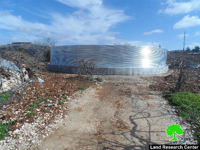
It is reported that the pools are constructed above the ground with a volume of 400m3 for each to collect water that will be later used for agricultural ends. The project of pools was implemented by Union of Agricultural Work Committee UAWC and Palestinian Hydrology Group.

The following table shows information about the affected owners and structures:

No.

Famer

Irrigated areadunum

No. of order

Photo of pool

1

Wahid Abu Maria 

8

200672

1

2

Ghassan Breighith

20

200670

2

3

Jamil Abu Maria

6

200673

3

4

Khalid Breighith

6

200669

4

Total

40


Source : Field observation- Department of Monitoring Israeli Violations- Land Research Center-2106


It should be marked that the town of Beit Ummar has been lately targeted by the occupation through enforcing closures and a fence at its entrance to hinder residents' movement. Not only, residents themselves in addition to structures are targeted .

About Beit Ummar:

It is located 12 km to Hebron city. The village's total area is 21,285 dunums , of which 1,375 dunums are considered the built-up area; around 13, 548 people inhabit Beit Ummar.

The Israeli occupation authorities confiscated 560 dunums from Beit Ummar for the favor of the bypass road no.60.  The occupation also confiscated 1,216 dunums for the favor of the following colonies:

Colony

Year of establishment

Dunums confiscated from Beit Ummar

Built-up areadunums

No. of colonists

Karmei Zur

1984

179

289

623

Migdal Oz

1977

682

10764

298

Kfar Etzion

1976

1806

923.5

404

Efrat

1976

98.6

206306

7037

Alon Shevut

1971

237.8

934

3146

Total

1216

5286.5

11508

Source: Geographic Information System- Monitoring Israeli Violations Team- Land Research Center


Prepared by
 The Land Research Center
LRC
 

Recommended For You

مناطق نفوذ المستوطنات ودورها في إعادة تشكيل الجغرافيا الفلسطينية

by arij
April 23, 2026
0
مناطق نفوذ المستوطنات ودورها في إعادة تشكيل الجغرافيا الفلسطينية

أصدرت سلطات الاحتلال الإسرائيلي في العاشر من شهر نيسان 2026 الكراسة رقم (273)، وهي وثيقة تضم مجموعة من المناشير والأوامر والتعيينات الإسرائيلية المتعلقة بالجوانب الأمنية والعسكرية والإدارية، إضافة...

Read moreDetails

INFOGRAPHIC: Mapping Control – Israeli Militray Orders across the occupied West Bank – 2025

by arij
April 16, 2026
0

    Prepared by:   The Applied Research Institute – Jerusalem

Read moreDetails

سلطات الاحتلال الإسرائيلي تستهدف قرية الجيب بأمر عسكري جديد

by arij
March 17, 2026
0
سلطات الاحتلال الإسرائيلي تستهدف قرية الجيب بأمر عسكري جديد

نشر المسؤول عن الأملاك الحكومية وأملاك الغائبين في الإدارة المدنية الإسرائيلية في الحادي عشر من شهر اذار من العام 2026 اعلاننا مفاده نية ما يسمى " المسؤول عن...

Read moreDetails

سلطات الاحتلال الإسرائيلي تستخدم الأوامر العسكرية لتعمق المشروع الاستيطاني في الضفة الغربية المحتلة

by arij
February 26, 2026
0
سلطات الاحتلال الإسرائيلي تستخدم الأوامر العسكرية لتعمق المشروع الاستيطاني في الضفة الغربية المحتلة

تقديم منذ احتلال الضفة الغربية عام 1967، اعتمدت سلطات الاحتلال الإسرائيلي منهجية واسعة عبر استخدام الأوامر العسكرية كأداة "قانونية" لفرض الوقائع الجغرافية والديموغرافية على الأرض الفلسطينية. وأصبحت هذه...

Read moreDetails

بين مطرقة الأوامر العسكرية وسندان التقييد الجغرافي, أوامر عسكرية إسرائيلية جديدة تطال أكثر من 1000 دونم في طوباس

by arij
November 26, 2025
0
بين مطرقة الأوامر العسكرية وسندان التقييد الجغرافي, أوامر عسكرية إسرائيلية جديدة تطال أكثر من 1000 دونم في طوباس

في الحادي والعشرين من شهر تشرين الأول لعام 2025، تسلّم أهالي محافظة طوباس سلسلة من الأوامر العسكرية الإسرائيلية التي استهدفت مساحات واسعة من الأراضي الفلسطينية في المحافظة. وقد...

Read moreDetails
Next Post

ARIJ Daily Report - Sat, 27th 02 2016

LATEST NEWS

بين قصرة وترمسعيا: العنف الاستيطاني الاسرائيلي يضرب المجتمع الفلسطيني

by arij
May 6, 2026
0

........................................................

مناطق نفوذ المستوطنات ودورها في إعادة تشكيل الجغرافيا الفلسطينية

مناطق نفوذ المستوطنات ودورها في إعادة تشكيل الجغرافيا الفلسطينية

by arij
April 23, 2026
0

........................................................

التمدد الاستيطاني الإسرائيلي في الضفة الغربية المحتلة وأثره في تقويض مقومات الدولة الفلسطينية

التمدد الاستيطاني الإسرائيلي في الضفة الغربية المحتلة وأثره في تقويض مقومات الدولة الفلسطينية

by arij
April 16, 2026
0

........................................................

INFOGRAPHIC: ISRAELI SETTLER VIOLENCE IN 2025

by arij
April 16, 2026
0

........................................................

flag_yellow_lowEU-PfP-Logo

This website and its content were initiated in 1993 by the Applied Research Institute – Jerusalem (ARIJ) and the Land Research Center (LRC) with the support from the European Union up until 2023. Since then, the Applied Research Institute – Jerusalem (ARIJ) has taken over the continued development and maintenance of the website. The views expressed remain solely those of ARIJ) and do not necessarily reflect those of the European Union.

© 2026 Copyright | ARIJ | All Rights reserved.

No Result
View All Result
  • Home
  • Settlements
    • New Israeli Settlements
    • Settlement Expansion
  • Israeli Violations
    • Agriculture
    • Confiscation
    • Demolition
    • Environment
    • Eviction of Palestinians
    • Settlers Attacks
  • Bypass Roads
  • Israeli Plans
  • Segregation
    • Checkpoints
    • Closure
    • Separation Plans
  • Military Orders
  • Reports
    • Daily Report
    • Monthly Report
    • Quarterly Report

© 2026 Copyright | ARIJ | All Rights reserved.