- Violation: notifying a road of stop-work
- Location: Al-Rahwa hamlet- Ad-Dhahiriya town
- Date: December 20, 2015
- Perpetrators: Israel Civil Administration and army troops
- Victims: residents of the hamlet
Details:
The Israeli occupation authorities notified on December 20, 2015 an agricultural road in Al-Rahwa hamlet, west Ad-Dhahiriya town in Hebron of stop-work and construction.
Eyewitnesses said that a vehicle relative to Israel Civil Administration arrived at the place and ordered the dozer to stop all construction works. The officer of the Civil Administration then issued a stop-work order addressing the project's contractor. The delivering act was documented in photos by the officer.
Noteworthy, the ID card of the dozer driver was detained and the driver was ordered to drive the dozer towards Ad-Dhahiriya crossing, where he was told that the work was taking place in a ban-of-work area. The driver went back to the location, tooksome of the equipment and left the site.


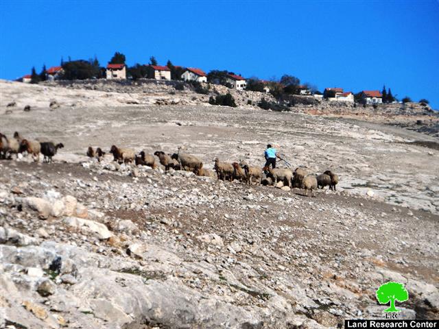
Photos 1-6: segments of the threatened road
The "stop-work and construction" order number 181673 mentioned that the works were "unlicensed" and ordered them halted. January 20, 2016 was assigned as the hearing session of the Inspection Sub-Committee in the Israeli court of Beit El to consider the legal status of the notified structure.

Photo A: the stop-work order
Residents of the area said that a vehicle arrived on December 21, 2015 and two people in civilians costumes launched a drone taking photos of the residential communities of the hamlet. Later, the two people were identified as members of Raghafayim colonial groups, which call on displacing Palestinian communities such like what happened weeks ago in Susiya hamlet, south Yatta.
Residents also said that a staff from the Civil Administration came to the hamlet and elicited some information about who provides them of solar panels, fodder and water and who their chieftain is. The staff then headed to the house of Mohammad Al-Til (70) and took a photo of his ID card for no reason.
On January 03, 2016, a vehicle from Israel Civil Administration arrived to the eastern side of the hamlet and confiscated iron poles from a construction location.
About the targeted road:
Action Against Hunger ACF organization started opening the notified road on November 2015; it was supposed to be of 2.2 km in length. The road was prepared with two base course layers on two segments of it; the long segment serves agricultural lands of citizens from Al-Dhahiriya where the shot one serves the residential community to the east of the hamlet.
Work was done in five culverts where other three are still to be completed since the occupation notified them of stop-work and construction.
It should be marked that the stream of sewage water that goes from Hebron to the occupied territories penetrates the hamlet's agricultural lands. Thus, most culverts were established to help residents reach the other side of their lands safely and easily.
The importance of the notified road:
Residents of the hamlet were excited for the road will be rehabilitated. One person said that he used to cross to the other side of his agricultural roads through the bridge that is on the culvert, another one said that its easier now to drive a tractor than it was before.
According to the rehabilitation plan, a culvert with a bridge above it was to be established at the main street for people to move safely, especially during winter.
Around 26 families and other farmers will directly benefit from the road. The names and information are as follows:
|
No. |
Name of farmer |
Owned area of landm2 |
|
1 |
Shihdih Samamrih |
10 |
|
2 |
Marwan Abu Sharkh |
14 |
|
3 |
Mohammad Al-Til |
25 |
|
4 |
Atta Makharzih |
12 |
|
5 |
Salem Abu Sharkh |
6 |
|
6 |
Muslim Abu Sharkh |
6 |
|
7 |
Sa'id Makharzih |
3 |
|
8 |
Issa Abu Sharkh |
10 |
|
9 |
Jamal Samamrih |
5 |
|
10 |
Ahmad Abu Sharkh |
5 |
|
11 |
Fakhri Abu Sharkh |
8 |
|
12 |
Muslim Salem Abu Sharkh |
5 |
|
13 |
Fayez Abu Sharkh |
15 |
|
14 |
Lutfi Abu Sharkh |
4 |
|
15 |
Attallah Makharzih |
3 |
|
16 |
Shihdih Makharzih |
7 |
|
17 |
Ahmad Abu Sharkh |
4 |
|
18 |
Mahmoud Makharzih |
5 |
|
19 |
Eid Hamed Makharzih |
5 |
|
20 |
Muslim Al-Til |
12 |
|
21 |
Rajih Al-Samamrih |
2 |
|
22 |
Ahmad Al-Samamrih |
6 |
|
|
|
172 |

It should also be marked that the road leads to the area of Wad Al-Simsim that is inhabited by two families. The lands in that area are agricultural. Such attacks and measures are carried out for the favor of the nearby Tina colony that is consistently expanding on the expense of Ad-Dhahiriya lands.


Photos 7-9: Tina colony overlooking Al-Rahwa hamlet
About al-Rahwa:
Al-Rahwa is located south of Al-Dhahiriya and east of Al-Ramadin towns. The hamlet was originally a primitive community for people who fully depended on livestock breeding and winter crops plantation. The area is considered an architectural Roman site with several caves being founded there.
The hamlet populates around 50 people; the population becomes 200 in spring for other families move in to graze their herds in the town’s pastures. Noteworthy, Tina colony overlooks the northern part of al-Rahwa and is 1km away from it. The segregation wall is there from the south as well as to Ad-Dhahiriya crossing, which leads to the occupied territories of 1948.


Photos 10-12: views of the hamlet
Prepared by
The Land Research Center
LRC