• About The Project
  • Palestine in Century
  • Selected Maps
  • Glossary
  • About ARIJ
  • About LRC
  • By Year
    • Case Studies By Year
    • Daily Report By Year
Sunday, June 14, 2026
POICA
No Result
View All Result
  • Home
  • Settlements
    • New Israeli Settlements
    • Settlement Expansion
  • Israeli Violations
    • Agriculture
    • Confiscation
    • Demolition
    • Environment
    • Eviction of Palestinians
    • Settlers Attacks
  • Bypass Roads
  • Israeli Plans
  • Segregation
    • Checkpoints
    • Closure
    • Separation Plans
  • Military Orders
  • Reports
    • Daily Report
    • Monthly Report
    • Quarterly Report
No Result
View All Result
POICA
No Result
View All Result

Israel declares 90 dunums of Ya’bad village closed military zones

December 23, 2015
in Military Orders
Israel declares 90 dunums of Ya’bad village closed military zones


  • Violation: declaring a Palestinian area closed military zone
  • Location:  Ya’bad village- Jenin
  • Date:  December 22, 2015
  • Perpetrators: Israeli occupation forces
  • Victims:  20 agricultural families

Details:

Agriculture is a crucial nerve for the prosperity of economy. As a matter of fact, 70% of the Palestinian community is rural, where people depend on agriculture to make living. It should be marked that the Israeli occupation worked day and night to steal Palestinian lands for the sake of carrying out colonial expansion plans.

The Israeli occupation issued on December 22, 2015 an order declaring an area of 90 dunums from Ya’bad village closed military zones. Noteworthy, the targeted area is adjacent to the bypass road number 585.


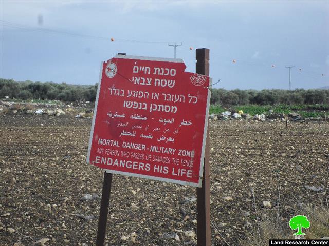
Photos 1-2: side of the targeted lands by the bypass road number 585

Photo 3: the military order served on the lands

The occupation justified this act as to create a buffer zone by a large segment of the bypass road to guarantee the safety of colonists traveling through the road to Mevo Dotan colony.

The mayor of Ya’bad, Yousef Atatrah, said that what is going on in the area is a continuation of an old plan the Israeli occupation started in 2010 to close the agricultural roads that link Ya’bad village to the bypass road number 585.

By the year of 2012, the occupation closed all coal factories founded by the bypass road. Noteworthy the factories provided sources of income for many workers from the area at time. In 2013, the occupation targeted the trees on both sides of the road claiming them to be hiding places of Palestinian attackers. Farmers and herders were not safe from the occupation measures of chasing, attacking and arresting; specifically in 2014. Finally, the occupation came today to establish a buffer zone to take over more land to be used for colonial purposes.

About Ya’bad village:

The village is located 18 km to the west of Jenin governorate. It is edged by the villages of Al-Khiljan, Al-Tarm, Al-Araqa, Imraiha and Khirbet Mas’oud, Zabda from the north, Qaffin village from the west, Al-Qaffriat village from the east and Arraba, Al-Nazla Al-Sharqiya and Baqa Al-Sharqiya from the south.

With a total land area of 29572 dunums, of which 1814 dunums are the built-up area, Ya’bad is inhabited by 13640 people (2007).

The occupation confiscated 1840 dunums from Ya’bad; the confiscation is clarified as follows:

  1. Israeli colonies confiscated 483 dunums as follows:

Colony

Year of establishment

Confiscated areadunum

No. of colonists

Mevo Dotan

  1.  
  1.  
  1.  

Jarmish

  1.  
  1.  
  1.  

Total

  1.  
  1.  


  1. Bypass roads number (569 & 585) confiscated 1357 dunums.

The lands of Ya’bad are classified, according to Oslo Accords, as follows:

  • 1674 dunums are classified as area “A”
  • 8124 dunums are classified as area “B”
  • 19774 dunums are classified as area “C”

Some International conventions and Humanitarian laws pertaining to attacks on land and natural resources are:

 Article 17 of the Universal Declaration of Human Rights states:

  • Everyone has the right to own property alone as well as in association with others.
  • No one shall be arbitrarily deprived of his property.

Article 1 of the International Covenant on Civil and Political Rights States:

"All peoples may, for their own ends, freely dispose of their natural wealth and resources without prejudice to any obligations arising out of international economic co-operation, based upon the principle of mutual benefit, and international law. In no case may a people be deprived of its own means of subsistence."


Prepared by
 The Land Research Center
LRC
 

Recommended For You

الاحتلال الاسرائيلي يوسع سيطرته على أراضي جبل الفرديس بمصادرة 317 دونما

by arij
June 13, 2026
0
الاحتلال الاسرائيلي يوسع سيطرته على أراضي جبل الفرديس بمصادرة 317 دونما

  في الخامس والعشرين من شهر ايار من العام 2026 نشرط سلطات الاحتلال الاسرائيلي امرا عسكريا جديدا يحمل اسم "أمر بشأن قانون الأراضي استملاك للمصلحة العامة) (يهودا والسامرة)...

Read moreDetails

بواقع 19 دونما – سلسلة من الأوامر العسكري الإسرائيلي تستهدف أراضي محافظة بيت لحم بذريعة الأغراض العسكرية

by arij
June 13, 2026
0
بواقع 19 دونما – سلسلة من الأوامر العسكري الإسرائيلي تستهدف أراضي محافظة بيت لحم بذريعة الأغراض العسكرية

سلمت سلطات الاحتلال الإسرائيلي أهالي محافظة بيت لحم سلسلة من الأوامر العسكرية لمصادرة مساحات شاسعة من الأراضي الفلسطينية في المحافظة بذريعة أغراض عسكرية. واستهدفت الأوامر العسكرية الجديدة عددا...

Read moreDetails

بمساحة اجمالية بلغت 208 دونما – سلطات الاحتلال الإسرائيلي تصادر الاراضي في محافظة طوباس لصالح معسكر اسرائيلي

by arij
June 13, 2026
0
بمساحة اجمالية بلغت 208 دونما – سلطات الاحتلال الإسرائيلي تصادر الاراضي في محافظة طوباس لصالح معسكر اسرائيلي

سلّمت سلطات الاحتلال الإسرائيلي، في السابع من حزيران 2026، أهالي مدينة طوباس شمال الضفة الغربية المحتلة أمراً عسكرياً جديداً بعنوان: "أمر بشأن وضع اليد على أراضٍ رقم 79/26/ت...

Read moreDetails

الاحتلال يرسّخ بؤرة “يتسيف” الاستيطانية عبر تخصيص 92 دونماً من أراضي بيت ساحور

by arij
June 9, 2026
0
الاحتلال يرسّخ بؤرة “يتسيف” الاستيطانية عبر تخصيص 92 دونماً من أراضي بيت ساحور

أصدر جيش الاحتلال الإسرائيلي في الخامس من شهر اذار من العام 2026 إعلاناً عسكرياً جديداً موقع من قبل ما يُسمّى بـ “قائد قوات جيش الدفاع الإسرائيلي في منطقة...

Read moreDetails

كراسة أوامر إسرائيلية جديدة تمهد لمصادرة أكثر من 20 ألف دونم في الضفة الغربية المحتلة

by arij
June 9, 2026
0
كراسة أوامر إسرائيلية جديدة تمهد لمصادرة أكثر من 20 ألف دونم في الضفة الغربية المحتلة

في الخامس من شهر اذار من العام 2026، أصدرت سلطات الاحتلال الإسرائيلي كراسة جديدة من الأوامر العسكرية التي تهدف إلى توسيع نطاق النشاطات الاستيطانية على الأراضي الفلسطينية، وذلك...

Read moreDetails
Next Post
Price Tag colonists attempt at burning down a Palestinian house

Price Tag colonists attempt at burning down a Palestinian house

LATEST NEWS

الاحتلال الاسرائيلي يوسع سيطرته على أراضي جبل الفرديس بمصادرة 317 دونما

الاحتلال الاسرائيلي يوسع سيطرته على أراضي جبل الفرديس بمصادرة 317 دونما

by arij
June 13, 2026
0

........................................................

بواقع 19 دونما – سلسلة من الأوامر العسكري الإسرائيلي تستهدف أراضي محافظة بيت لحم بذريعة الأغراض العسكرية

بواقع 19 دونما – سلسلة من الأوامر العسكري الإسرائيلي تستهدف أراضي محافظة بيت لحم بذريعة الأغراض العسكرية

by arij
June 13, 2026
0

........................................................

بمساحة اجمالية بلغت 208 دونما – سلطات الاحتلال الإسرائيلي تصادر الاراضي في محافظة طوباس لصالح معسكر اسرائيلي

بمساحة اجمالية بلغت 208 دونما – سلطات الاحتلال الإسرائيلي تصادر الاراضي في محافظة طوباس لصالح معسكر اسرائيلي

by arij
June 13, 2026
0

........................................................

الاحتلال يرسّخ بؤرة “يتسيف” الاستيطانية عبر تخصيص 92 دونماً من أراضي بيت ساحور

الاحتلال يرسّخ بؤرة “يتسيف” الاستيطانية عبر تخصيص 92 دونماً من أراضي بيت ساحور

by arij
June 9, 2026
0

........................................................

flag_yellow_lowEU-PfP-Logo

This website and its content were initiated in 1993 by the Applied Research Institute – Jerusalem (ARIJ) and the Land Research Center (LRC) with the support from the European Union up until 2023. Since then, the Applied Research Institute – Jerusalem (ARIJ) has taken over the continued development and maintenance of the website. The views expressed remain solely those of ARIJ) and do not necessarily reflect those of the European Union.

© 2026 Copyright | ARIJ | All Rights reserved.

No Result
View All Result
  • Home
  • Settlements
    • New Israeli Settlements
    • Settlement Expansion
  • Israeli Violations
    • Agriculture
    • Confiscation
    • Demolition
    • Environment
    • Eviction of Palestinians
    • Settlers Attacks
  • Bypass Roads
  • Israeli Plans
  • Segregation
    • Checkpoints
    • Closure
    • Separation Plans
  • Military Orders
  • Reports
    • Daily Report
    • Monthly Report
    • Quarterly Report

© 2026 Copyright | ARIJ | All Rights reserved.