• About The Project
  • Palestine in Century
  • Selected Maps
  • Glossary
  • About ARIJ
  • About LRC
  • By Year
    • Case Studies By Year
    • Daily Report By Year
Sunday, June 14, 2026
POICA
No Result
View All Result
  • Home
  • Settlements
    • New Israeli Settlements
    • Settlement Expansion
  • Israeli Violations
    • Agriculture
    • Confiscation
    • Demolition
    • Environment
    • Eviction of Palestinians
    • Settlers Attacks
  • Bypass Roads
  • Israeli Plans
  • Segregation
    • Checkpoints
    • Closure
    • Separation Plans
  • Military Orders
  • Reports
    • Daily Report
    • Monthly Report
    • Quarterly Report
No Result
View All Result
POICA
No Result
View All Result

Itamar colonists ban surveying works in Aorta-Yanun road

July 9, 2015
in Settlers Attacks
Itamar colonists ban surveying works in Aorta-Yanun road


Violation: banning survey workers from working in a road

Location:  Al-Yanun-Aorta /Nablus

Date:  July 09, 2015

Perpetrators: Itamar colonists

Victims:  residents of Nablus southern suburbs

Details:

A group of Itamar colonists that is founded on confiscated lands from Aorta and Aqraba villages on July 09, 2015 banned workers from Ministry of Public Works from completing surveying points on the road of Aorta-Yanun. The road was reported open in 2013 to be rehabilitated and used by the residents of Nablus southern suburbs.

The mayor of Aqraba village Mr. Ayman Bani Fadil told a researcher from Land Research Center the following:

“We lately managed to obtain a fund to rehabilitate the road(located within lands classified as area “B” according to Oslo Accords) though UNDP; 4km of the road were supposed to be rehabilitated. At time of implementing the project, Itamar colonists came and sent the workers of the Ministry of Public Works out of the area and banned others from rehabilitating the road”.

He also added:

“Previous coordination was made through Israel District of Coordination Office to let workers survey the area, and yet the occupation army prohibited them from carrying on their work”

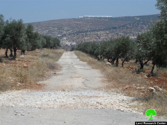
Photo 1:  Aorta-Yanun road with a view of Itamar colony in the back ground


It should be marked that the road was closed from 2000 until 2013 under “security purposes” as the occupation claimed. Colonists invested all efforts to take over the area through targeting lands by using them as pastures for their animals and destroying crops in there.

The road is only 1km away from Itamar; colonists carry out attacks and violations under the watchful eye of the Israeli occupation soldiers, who provide utmost protection and give hand to colonist at time of attacks as well.

In the aftermath of the second intifada, the road was closed as part of the closure and siege plan imposed by the occupation on the West Bank.

About Aorta-Yanun road:

It is indicated that this road dates back to the Ottoman era, where it was used as an economical and agricultural passageway, serving the villages of Nablus southern suburbs namely (Aorta, Al-Yanun, Beita, Aqraba, Osrin, and Majdal Bani Fadil). The road serves hundreds of agricultural dunums of olive groves, which are hard to access but through this very road.

Despite the road is claimed opened by the Israeli occupation, Palestinian cannot pass through it without being attacked and violated by colonists if Itamar. As a result, residents now are forced to take a new route through Beita village to go Nablus from where they are. The new route is double in distance than the original one and causes more fatigue to travelers. 


Prepared by
 The Land Research Center
LRC
 

Recommended For You

بين قصرة وترمسعيا: العنف الاستيطاني الاسرائيلي يضرب المجتمع الفلسطيني

by arij
May 6, 2026
0

في الثالث من شهر أيار من العام 2026، شهد مزارعون في عدة قرى في الضفة الغربية المحتلة على مشهد بات مألوفًا وقاسيا في آنٍ واحد: أشجار مثمرة مقطوعة...

Read moreDetails

INFOGRAPHIC: ISRAELI SETTLER VIOLENCE IN 2025

by arij
April 16, 2026
0

INFOGRAPHIC: ISRAELI SETTLER VIOLENCE IN 2025     Prepared by:   The Applied Research Institute – Jerusalem  

Read moreDetails

The West Bank: Between Settler Aggression and Occupation Support – 2025 Highlights

by arij
March 25, 2026
0
The West Bank: Between Settler Aggression and Occupation Support – 2025 Highlights

In the occupied West Bank (oWB), the violence committed by Israeli settlers is no longer a series of isolated, random attacks; it has effectively become a de facto...

Read moreDetails

From a Circle of Violence to a Circle of Impunity: The Structural Empowerment of Settlers

by arij
November 24, 2025
0

Beyond the “Violence Circle” In much of the global discourse, the Israeli settlers on the Palestinians frame the Israeli–Palestinian conflict as a “circle of violence”, a continuous sequence...

Read moreDetails

من دائرة العنف إلى دائرة الإفلات من العقاب: التمكين البنيوي للمستوطنين الإسرائيليين

by arij
November 24, 2025
0
“ما يزيد عن 25 ألف دونم من أراض الزيتون”, موسم الزيتون في فلسطين تحت رهن الأوامر العسكرية

ما وراء "دائرة العنف"              يشهد الصراع الفلسطيني الإسرائيلي منذ عقود متغيرات دراماتيكية، حيث يتجاوز العنف الذي تمارسه اسرائيل على الأرض الحدود التقليدية للمواجهات المسلحة ليصبح جزءا من هيكلية...

Read moreDetails
Next Post
مستعمرو “ايتمار” يمنعون فرق المساحة من العمل على طريق عورتا – اليانون

مستعمرو "ايتمار" يمنعون فرق المساحة من العمل على طريق عورتا – اليانون

LATEST NEWS

الاحتلال الاسرائيلي يوسع سيطرته على أراضي جبل الفرديس بمصادرة 317 دونما

الاحتلال الاسرائيلي يوسع سيطرته على أراضي جبل الفرديس بمصادرة 317 دونما

by arij
June 13, 2026
0

........................................................

بواقع 19 دونما – سلسلة من الأوامر العسكري الإسرائيلي تستهدف أراضي محافظة بيت لحم بذريعة الأغراض العسكرية

بواقع 19 دونما – سلسلة من الأوامر العسكري الإسرائيلي تستهدف أراضي محافظة بيت لحم بذريعة الأغراض العسكرية

by arij
June 13, 2026
0

........................................................

بمساحة اجمالية بلغت 208 دونما – سلطات الاحتلال الإسرائيلي تصادر الاراضي في محافظة طوباس لصالح معسكر اسرائيلي

بمساحة اجمالية بلغت 208 دونما – سلطات الاحتلال الإسرائيلي تصادر الاراضي في محافظة طوباس لصالح معسكر اسرائيلي

by arij
June 13, 2026
0

........................................................

الاحتلال يرسّخ بؤرة “يتسيف” الاستيطانية عبر تخصيص 92 دونماً من أراضي بيت ساحور

الاحتلال يرسّخ بؤرة “يتسيف” الاستيطانية عبر تخصيص 92 دونماً من أراضي بيت ساحور

by arij
June 9, 2026
0

........................................................

flag_yellow_lowEU-PfP-Logo

This website and its content were initiated in 1993 by the Applied Research Institute – Jerusalem (ARIJ) and the Land Research Center (LRC) with the support from the European Union up until 2023. Since then, the Applied Research Institute – Jerusalem (ARIJ) has taken over the continued development and maintenance of the website. The views expressed remain solely those of ARIJ) and do not necessarily reflect those of the European Union.

© 2026 Copyright | ARIJ | All Rights reserved.

No Result
View All Result
  • Home
  • Settlements
    • New Israeli Settlements
    • Settlement Expansion
  • Israeli Violations
    • Agriculture
    • Confiscation
    • Demolition
    • Environment
    • Eviction of Palestinians
    • Settlers Attacks
  • Bypass Roads
  • Israeli Plans
  • Segregation
    • Checkpoints
    • Closure
    • Separation Plans
  • Military Orders
  • Reports
    • Daily Report
    • Monthly Report
    • Quarterly Report

© 2026 Copyright | ARIJ | All Rights reserved.