• About The Project
  • Palestine in Century
  • Selected Maps
  • Glossary
  • About ARIJ
  • About LRC
  • By Year
    • Case Studies By Year
    • Daily Report By Year
Friday, May 15, 2026
POICA
No Result
View All Result
  • Home
  • Settlements
    • New Israeli Settlements
    • Settlement Expansion
  • Israeli Violations
    • Agriculture
    • Confiscation
    • Demolition
    • Environment
    • Eviction of Palestinians
    • Settlers Attacks
  • Bypass Roads
  • Israeli Plans
  • Segregation
    • Checkpoints
    • Closure
    • Separation Plans
  • Military Orders
  • Reports
    • Daily Report
    • Monthly Report
    • Quarterly Report
No Result
View All Result
POICA
No Result
View All Result

Extending the validity of a land grab in Ramallah

January 24, 2015
in Military Orders
Extending the validity of a land grab in Ramallah


Violation: serving an order to extend validity of a land grab

Date :03/12/2014

Location: the villages of Deir Balut, Rantis, Shabqa and Qibya

Perpetrators: the Israeli occupation army

Victims : residents of the villages

Details:

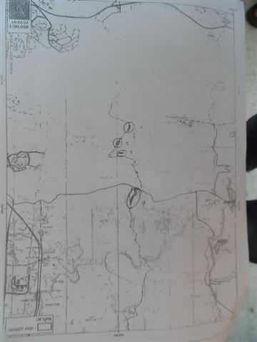
In a new step taken in favor of the apartheid wall, the Israeli occupation army on December 03, 2014 served  the Palestinian District Coordination Office DCO a number of military orders signed by Israeli army commander Nitzan Alof. The orders stressed on extending the validity of a land grab for tens of dunums  in the villages of Deir Balut, Rantis, Shabqa and Qibya , northwest of Ramallah governorate.

Regarding Rantis and Deir Balut land confiscation , the orders were issued to establish new segments of the wall in the northern part of Rantis village and the southern part of Deir Balut village. The later was planned to circulate the colony of Beit Arye, which is located in the nearby. Noteworthy, the work in those segments is not over yet. The following table lists the damages inflected on the targeted villages:

No. of order Status of the wall Area according to order dunum Targeted villages No. of natural block Number
ames of plots
Photo of the confiscated area
Order no. (03/69/C) for extending validity and borders amending A built segment 231 Rantis 2 Kanet Abu Hosh, Sheib Beir er-Rayis, Karnet Salem, Dirwil, al-Wajh al-Gharbi, al-Qarn,Sheib Batta, Jafha, Sheib Deir al-Kharub 1+2+3+4
Shaqba 3 Maued Oud Mhdad
Qibya 2 Hariqat al-Si'ba
Bodrus 10 Khalet al-Nasara
Order no.( 04/71/ C) for extending validity and borders amending Under construction 48.9 Khirbet Mismir, Deir Balut 1 +3 El-Safha esh-Shamiya , Khirbet Ta'mr, Habil al-Masloul 5+6
Rantis 2 Mawki' al-Manzel, al-Tin al-Gharbi
Total 279.9        


Source: Filed observation- Department of Monitoring  Israeli Violation- Land Research Center

According to the military orders, the Israeli occupation granted itself the ownership of  lands, which are confiscated  in 2003, until 2017; the army has the right to extend the confiscation validity on the lands as well.

Land Research Center LRC sees that land grab contradicts with all  of the International conventions and Humanitarian laws including:

  • Article 17 of the (1948) Universal Declaration of Human Rights stating: “Everyone has the right to own property alone as well as in association with others. No one shall be arbitrarily deprived of his property.”

·         Article 147 of the Fourth Geneva Convention of 1949 indicated that: 

Extensive destruction and appropriation of property not justified by military necessity and carried out unlawfully and wantonly. is a grave breach of the Convention.


Prepared by

 The Land Research Center
LRC
 

Recommended For You

مناطق نفوذ المستوطنات ودورها في إعادة تشكيل الجغرافيا الفلسطينية

by arij
April 23, 2026
0
مناطق نفوذ المستوطنات ودورها في إعادة تشكيل الجغرافيا الفلسطينية

أصدرت سلطات الاحتلال الإسرائيلي في العاشر من شهر نيسان 2026 الكراسة رقم (273)، وهي وثيقة تضم مجموعة من المناشير والأوامر والتعيينات الإسرائيلية المتعلقة بالجوانب الأمنية والعسكرية والإدارية، إضافة...

Read moreDetails

INFOGRAPHIC: Mapping Control – Israeli Militray Orders across the occupied West Bank – 2025

by arij
April 16, 2026
0

    Prepared by:   The Applied Research Institute – Jerusalem

Read moreDetails

سلطات الاحتلال الإسرائيلي تستهدف قرية الجيب بأمر عسكري جديد

by arij
March 17, 2026
0
سلطات الاحتلال الإسرائيلي تستهدف قرية الجيب بأمر عسكري جديد

نشر المسؤول عن الأملاك الحكومية وأملاك الغائبين في الإدارة المدنية الإسرائيلية في الحادي عشر من شهر اذار من العام 2026 اعلاننا مفاده نية ما يسمى " المسؤول عن...

Read moreDetails

سلطات الاحتلال الإسرائيلي تستخدم الأوامر العسكرية لتعمق المشروع الاستيطاني في الضفة الغربية المحتلة

by arij
February 26, 2026
0
سلطات الاحتلال الإسرائيلي تستخدم الأوامر العسكرية لتعمق المشروع الاستيطاني في الضفة الغربية المحتلة

تقديم منذ احتلال الضفة الغربية عام 1967، اعتمدت سلطات الاحتلال الإسرائيلي منهجية واسعة عبر استخدام الأوامر العسكرية كأداة "قانونية" لفرض الوقائع الجغرافية والديموغرافية على الأرض الفلسطينية. وأصبحت هذه...

Read moreDetails

بين مطرقة الأوامر العسكرية وسندان التقييد الجغرافي, أوامر عسكرية إسرائيلية جديدة تطال أكثر من 1000 دونم في طوباس

by arij
November 26, 2025
0
بين مطرقة الأوامر العسكرية وسندان التقييد الجغرافي, أوامر عسكرية إسرائيلية جديدة تطال أكثر من 1000 دونم في طوباس

في الحادي والعشرين من شهر تشرين الأول لعام 2025، تسلّم أهالي محافظة طوباس سلسلة من الأوامر العسكرية الإسرائيلية التي استهدفت مساحات واسعة من الأراضي الفلسطينية في المحافظة. وقد...

Read moreDetails
Next Post

ARIJ Daily Report - Sat, 24th 01 2015

LATEST NEWS

بين قصرة وترمسعيا: العنف الاستيطاني الاسرائيلي يضرب المجتمع الفلسطيني

by arij
May 6, 2026
0

........................................................

مناطق نفوذ المستوطنات ودورها في إعادة تشكيل الجغرافيا الفلسطينية

مناطق نفوذ المستوطنات ودورها في إعادة تشكيل الجغرافيا الفلسطينية

by arij
April 23, 2026
0

........................................................

التمدد الاستيطاني الإسرائيلي في الضفة الغربية المحتلة وأثره في تقويض مقومات الدولة الفلسطينية

التمدد الاستيطاني الإسرائيلي في الضفة الغربية المحتلة وأثره في تقويض مقومات الدولة الفلسطينية

by arij
April 16, 2026
0

........................................................

INFOGRAPHIC: ISRAELI SETTLER VIOLENCE IN 2025

by arij
April 16, 2026
0

........................................................

flag_yellow_lowEU-PfP-Logo

This website and its content were initiated in 1993 by the Applied Research Institute – Jerusalem (ARIJ) and the Land Research Center (LRC) with the support from the European Union up until 2023. Since then, the Applied Research Institute – Jerusalem (ARIJ) has taken over the continued development and maintenance of the website. The views expressed remain solely those of ARIJ) and do not necessarily reflect those of the European Union.

© 2026 Copyright | ARIJ | All Rights reserved.

No Result
View All Result
  • Home
  • Settlements
    • New Israeli Settlements
    • Settlement Expansion
  • Israeli Violations
    • Agriculture
    • Confiscation
    • Demolition
    • Environment
    • Eviction of Palestinians
    • Settlers Attacks
  • Bypass Roads
  • Israeli Plans
  • Segregation
    • Checkpoints
    • Closure
    • Separation Plans
  • Military Orders
  • Reports
    • Daily Report
    • Monthly Report
    • Quarterly Report

© 2026 Copyright | ARIJ | All Rights reserved.