• About The Project
  • Palestine in Century
  • Selected Maps
  • Glossary
  • About ARIJ
  • About LRC
  • By Year
    • Case Studies By Year
    • Daily Report By Year
Tuesday, June 2, 2026
POICA
No Result
View All Result
  • Home
  • Settlements
    • New Israeli Settlements
    • Settlement Expansion
  • Israeli Violations
    • Agriculture
    • Confiscation
    • Demolition
    • Environment
    • Eviction of Palestinians
    • Settlers Attacks
  • Bypass Roads
  • Israeli Plans
  • Segregation
    • Checkpoints
    • Closure
    • Separation Plans
  • Military Orders
  • Reports
    • Daily Report
    • Monthly Report
    • Quarterly Report
No Result
View All Result
POICA
No Result
View All Result

The Israeli occupation notifies 7 agricultural dunums with evection in the village of Wadi Rahhal

April 29, 2014
in Military Orders
The Israeli occupation notifies 7 agricultural dunums with evection in the village of Wadi Rahhal


Violation: a military order to confiscate 7 dunums

Location: Wadi Rahhal/  Bethlehem

Perpetrators: the army of the Israeli occupation

Victims: Abdelaziz Shwaiki and his brothers

Details :

Israel Inspection Central Committee notified on April 29, 2013 a 7dunum plot with evection. The land is owned by citizen Abdelaziz Shwaiki(58) and his brothers. More specifically, the land is located in the area of Wadi Rahhal, south of Bethlehem governorate; the occupation claimed the land as "State land". In case the land grab takes place, many neighboring lands from Bethlehem will be under the spot of targeting and will be threatened with confiscation as well.

It should be marked that part of the  targeted lands is  planted with olive trees where the other parts are unused. According to the military order, an article gave owners a 45 day objection  period on the order. Noteworthy, such articles are only superficial and never ended up in favor of Palestinians.

 From another side, the chairman of Wadi Rahhal village council asserted that the aim behind such Israeli activities in the area is to expand the colony of Efrat that is located in the nearby .

Photos 1-3: the targeted land by the order
 

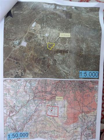
Photo: 4: the military order with a map indicating the confiscated areas attached


About Wadi Rahhal :

It is one of villages relative to Bethlehem governorate  and is located to the south of it. The village is edged by Janatah from the east, al-Khadr from the north, Wadi al-Nis from the west and Jurat al-Sham'a from the south.

For further information about the assaults and violations Wadi Rahhal underwent during 2012, please read through the reports issued by Land Research Center as follows:

  • A military order to confiscate lands from the areas of Wadi Rahhal, Wadi al-Nis and Um Salamona (Ar, Eng)
  • A stop-work order on a house in the village of Wadi Rahhal (Ar, Eng) 


Prepared by
The Land Research Center
LRC

Recommended For You

سلطات الاحتلال الإسرائيلي بصدد الاستيلاء على موقع قبر النبي صموئيل شمال غرب مدينة القدس

by arij
May 23, 2026
0
سلطات الاحتلال الإسرائيلي بصدد الاستيلاء على موقع قبر النبي صموئيل شمال غرب مدينة القدس

 نشرت سلطات الاحتلال الإسرائيلي في الثامن عشر من شهر أيار من العام 2026 اعلانا مفاده الاستيلاء على الأراضي الفلسطينية في قرية النبي صموئيل شمال غرب القدس المحتلة. وجاء...

Read moreDetails

إقامة منطقة عسكرية عسكرية داخل أراضي (أ) في جنين

by arij
May 19, 2026
0
إقامة منطقة عسكرية عسكرية داخل أراضي (أ) في جنين

   في السابع من شهر أيار من العام 2026، وزعت سلطات الاحتلال الإسرائيلي أمرا عسكريا جديدة على أهالي مدينة جنين يقضي بمصادرة 7.2 دونما من الأراضي الفلسطينية في...

Read moreDetails

“بمساحة اجمالية 177 دونما من أرضي البيرة وبيتين”, طريق استيطاني لخدمة البؤر الاستيطانية في محافظة رام الله

by arij
May 18, 2026
0
“بمساحة اجمالية 177 دونما من أرضي البيرة وبيتين”, طريق استيطاني لخدمة البؤر الاستيطانية في محافظة رام الله

في الحادي عشر من شهر أيار من العام 2026, نشرت دائرة أراضي إسرائيل اعلانا جديدا يقضي بمصادرة المزيد من الأراضي الفلسطينية في محافظة رام الله لأغراض استيطانية في...

Read moreDetails

“في خدمة مستوطنة ناحال حيلتس”, طريق استيطاني إسرائيلي جديد على أراضي بتير وبيت جالا في محافظة بيت لحم

by arij
May 18, 2026
0
“في خدمة مستوطنة ناحال حيلتس”, طريق استيطاني إسرائيلي جديد على أراضي بتير وبيت جالا في محافظة بيت لحم

تواصل سلطات الاحتلال الإسرائيلي إحكام سيطرتها على المزيد من الأراضي الفلسطينية في الضفة الغربية المحتلة، وهذه المرة من خلال استهداف أراضي محافظة بيت لحم. ففي السادس والعشرين من...

Read moreDetails

مناطق نفوذ المستوطنات ودورها في إعادة تشكيل الجغرافيا الفلسطينية

by arij
April 23, 2026
0
مناطق نفوذ المستوطنات ودورها في إعادة تشكيل الجغرافيا الفلسطينية

أصدرت سلطات الاحتلال الإسرائيلي في العاشر من شهر نيسان 2026 الكراسة رقم (273)، وهي وثيقة تضم مجموعة من المناشير والأوامر والتعيينات الإسرائيلية المتعلقة بالجوانب الأمنية والعسكرية والإدارية، إضافة...

Read moreDetails
Next Post

ARIJ Daily Report - Tue, 29th 04 2014

LATEST NEWS

سلطات الاحتلال الإسرائيلي بصدد الاستيلاء على موقع قبر النبي صموئيل شمال غرب مدينة القدس

سلطات الاحتلال الإسرائيلي بصدد الاستيلاء على موقع قبر النبي صموئيل شمال غرب مدينة القدس

by arij
May 23, 2026
0

........................................................

إقامة منطقة عسكرية عسكرية داخل أراضي (أ) في جنين

إقامة منطقة عسكرية عسكرية داخل أراضي (أ) في جنين

by arij
May 19, 2026
0

........................................................

الآثار كأداة للضم الزاحف: مشروع القانون الإسرائيلي لإعادة هندسة الجغرافيا والهوية في الضفة الغربية

الآثار كأداة للضم الزاحف: مشروع القانون الإسرائيلي لإعادة هندسة الجغرافيا والهوية في الضفة الغربية

by arij
May 23, 2026
0

........................................................

النكبة الفلسطينية في ذكراها الثامنة والسبعين: من التطهير العرقي إلى الإبادة وإعادة هندسة الجغرافيا الفلسطينية 

النكبة الفلسطينية في ذكراها الثامنة والسبعين: من التطهير العرقي إلى الإبادة وإعادة هندسة الجغرافيا الفلسطينية 

by arij
May 18, 2026
0

........................................................

flag_yellow_lowEU-PfP-Logo

This website and its content were initiated in 1993 by the Applied Research Institute – Jerusalem (ARIJ) and the Land Research Center (LRC) with the support from the European Union up until 2023. Since then, the Applied Research Institute – Jerusalem (ARIJ) has taken over the continued development and maintenance of the website. The views expressed remain solely those of ARIJ) and do not necessarily reflect those of the European Union.

© 2026 Copyright | ARIJ | All Rights reserved.

No Result
View All Result
  • Home
  • Settlements
    • New Israeli Settlements
    • Settlement Expansion
  • Israeli Violations
    • Agriculture
    • Confiscation
    • Demolition
    • Environment
    • Eviction of Palestinians
    • Settlers Attacks
  • Bypass Roads
  • Israeli Plans
  • Segregation
    • Checkpoints
    • Closure
    • Separation Plans
  • Military Orders
  • Reports
    • Daily Report
    • Monthly Report
    • Quarterly Report

© 2026 Copyright | ARIJ | All Rights reserved.