• About The Project
  • Palestine in Century
  • Selected Maps
  • Glossary
  • About ARIJ
  • About LRC
  • By Year
    • Case Studies By Year
    • Daily Report By Year
Thursday, April 16, 2026
POICA
No Result
View All Result
  • Home
  • Settlements
    • New Israeli Settlements
    • Settlement Expansion
  • Israeli Violations
    • Agriculture
    • Confiscation
    • Demolition
    • Environment
    • Eviction of Palestinians
    • Settlers Attacks
  • Bypass Roads
  • Israeli Plans
  • Segregation
    • Checkpoints
    • Closure
    • Separation Plans
  • Military Orders
  • Reports
    • Daily Report
    • Monthly Report
    • Quarterly Report
No Result
View All Result
POICA
No Result
View All Result

Razing a barn in Al ‘Auja

January 9, 2014
in Settlements
Razing a barn in Al ‘Auja

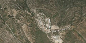
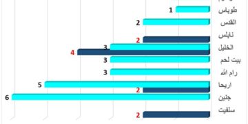
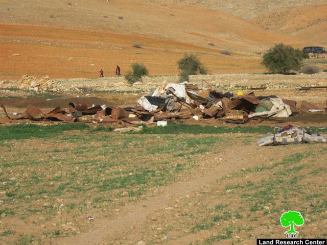
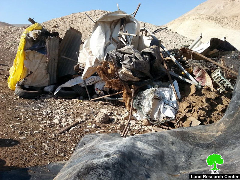
Violation: The Israeli occupation demolished a barn in Al ‘Auja

Date: 08/01/2014

Location: Al ‘Auja- Jericho governorate

Victims: Family of Mossa Al Najada

Perpetrators: The Israeli occupation army

Details:

On Wednesday, January 01, Al ‘Auja witnessed a new wave of attack when an Israeli military force accompanying a bulldozer raided Arab Al Ka’abna dwelling where they demolished a barn without any prior warning under the pretext of unlicensed construction in an area classified C according to Oslo Accords. The barn belonged to the family of Mossa Al Najada. It should be remarked that it was the eighth time Al Najada was targeted and his structures demolished. 

Picture of the targeted barn

Affected citizen

Family

Children

Sheep

Structure

Area

Picture

Mossa Al Najada

11

4

180

Barn

120 m2

1

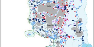
Al 'Auja – an Overview:

It is located 12 km to the north east of Jericho city, adjacent to the Jordan River. It is edged by the eastern regional road that leads far north to Bisan. Its total area is 106399 dunums, 1186 of which is built up area of the village. The village's boundaries reach up to Fasayel in the north and An Nuwei'ma (south), Jordan River (east) and Ramallah Mountains (west). Residents depend largely on agriculture in their living because of the availability of water.

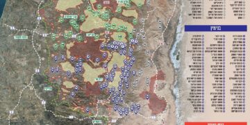
The Israeli Occupation captured 4717 dunums of Al 'Auja for colonial expansion purposes besides having several military bases there that devoured 1600 dunums. Road no. 90 which is 8180 long took away more than 818 dunums of Al ‘Auja. 5 colonies are founded on Al ‘Auja land and they devoured 2299 dunums of the village. The colonies are:

Colony

Year of construction

Confiscation/ dunum

No. of colonists

Gilgal

1970

287

162

Netiv Hagedud

1975

1,004

120

Niran

1981

441

52

Yitav

1970

514

136

Nihal Tsoori

1981

53

N.A

Sum

9877

2,299

470

Prepared by
 The Land Research Center
LRC
 

Recommended For You

التمدد الاستيطاني الإسرائيلي في الضفة الغربية المحتلة وأثره في تقويض مقومات الدولة الفلسطينية

by arij
April 16, 2026
0
التمدد الاستيطاني الإسرائيلي في الضفة الغربية المحتلة وأثره في تقويض مقومات الدولة الفلسطينية

في التاسع من شهر نيسان من العام 2026، أعلن ما يسمى "بالمجلس الوزاري الأمني المصغر" مصادقته على إقامة وشرعنة 34 مستوطنة جديدة في الضفة الغربية المحتلة. وجاء هذا...

Read moreDetails

انفوجرافيك: التوسع الاستيطاني الاسرائيلي خلال العام 2025

by arij
April 16, 2026
0

انفوجرافيك: خريطة الضفة الغربية تتقلص بفعل المخططات الاستيطانية الاسرائيلية اعداد: معهد الابحاث التطبيقية – القدس ( أريج)

Read moreDetails

على ما مساحته 1006.4 دونما من أراضي بلدة يانون
“سلطات الاحتلال الإسرائيلي تشرع بتغيير نفوذ بؤرة استيطانية في الضفة الغربية المحتلة”

by arij
March 14, 2026
0
على ما مساحته 1006.4 دونما من أراضي بلدة يانون  “سلطات الاحتلال الإسرائيلي تشرع بتغيير نفوذ بؤرة استيطانية في الضفة الغربية المحتلة”

في الثاني عشر من شهر شباط من العام 2026, نشر رئيس قسم الاستيطان والتنظيم فيما يسمى "بالإدارة المدنية الإسرائيلية", الذراع الأيمن لحكومة الاحتلال الإسرائيلية اعلانا مفاده " اعلان...

Read moreDetails

حين تتقلص الخريطة: تسارع غير مسبوق في توسّع المستوطنات الإسرائيلية خلال عام 2025

by arij
February 16, 2026
0
حين تتقلص الخريطة: تسارع غير مسبوق في توسّع المستوطنات الإسرائيلية خلال عام 2025

مقدمة: - ان السياسة الاستيطانية الإسرائيلية في الضفة الغربية المحتلة هي واحدة من أكثر القضايا التي تقف عائقا في تحقيق سلام عادل وقابل للحياة في الأراضي الفلسطينية المحتلة....

Read moreDetails

بيت ساحور “مدينة الرعاة” بين الواقع والاستيطان
“بؤرة استيطانية إسرائيلية جديدة على تلة عش غراب” 

by arij
November 24, 2025
0
بيت ساحور “مدينة الرعاة” بين الواقع والاستيطان “بؤرة استيطانية إسرائيلية جديدة على تلة عش غراب” 

تشهد منطقة عش غراب في مدينة بيت ساحور تصعيدا خطيرا من قبل سلطات الاحتلال والمستوطنين، حيث تقوم جماعات المستوطنين، وتحت إشراف ما يطلق عليه "بمجلس إقليمي جوش عتصيون...

Read moreDetails
Next Post
The Israeli occupation demolishes a number of residences and barns in Al Jiftlik

The Israeli occupation demolishes a number of residences and barns in Al Jiftlik

LATEST NEWS

التمدد الاستيطاني الإسرائيلي في الضفة الغربية المحتلة وأثره في تقويض مقومات الدولة الفلسطينية

التمدد الاستيطاني الإسرائيلي في الضفة الغربية المحتلة وأثره في تقويض مقومات الدولة الفلسطينية

by arij
April 16, 2026
0

........................................................

INFOGRAPHIC: ISRAELI SETTLER VIOLENCE IN 2025

by arij
April 16, 2026
0

........................................................

العدالة المؤجلة ورأي بلا تنفيذ: من قرار المحكمة إلى واقع الضم

أدوات غير مباشرة للاستيطان الإسرائيلي في مناطق (أ) و(ب) لإعادة تشكيل الجغرافيا والسيطرة في الضفة الغربية   

by arij
April 16, 2026
0

........................................................

INFOGRAPHIC: Palestinian Trees – Victims of the Israeli occupation Army & Settler Groups in 2025

by arij
April 16, 2026
0

........................................................

flag_yellow_lowEU-PfP-Logo

This website and its content were initiated in 1993 by the Applied Research Institute – Jerusalem (ARIJ) and the Land Research Center (LRC) with the support from the European Union up until 2023. Since then, the Applied Research Institute – Jerusalem (ARIJ) has taken over the continued development and maintenance of the website. The views expressed remain solely those of ARIJ) and do not necessarily reflect those of the European Union.

© 2026 Copyright | ARIJ | All Rights reserved.

No Result
View All Result
  • Home
  • Settlements
    • New Israeli Settlements
    • Settlement Expansion
  • Israeli Violations
    • Agriculture
    • Confiscation
    • Demolition
    • Environment
    • Eviction of Palestinians
    • Settlers Attacks
  • Bypass Roads
  • Israeli Plans
  • Segregation
    • Checkpoints
    • Closure
    • Separation Plans
  • Military Orders
  • Reports
    • Daily Report
    • Monthly Report
    • Quarterly Report

© 2026 Copyright | ARIJ | All Rights reserved.