• About The Project
  • Palestine in Century
  • Selected Maps
  • Glossary
  • About ARIJ
  • About LRC
  • By Year
    • Case Studies By Year
    • Daily Report By Year
Monday, May 25, 2026
POICA
No Result
View All Result
  • Home
  • Settlements
    • New Israeli Settlements
    • Settlement Expansion
  • Israeli Violations
    • Agriculture
    • Confiscation
    • Demolition
    • Environment
    • Eviction of Palestinians
    • Settlers Attacks
  • Bypass Roads
  • Israeli Plans
  • Segregation
    • Checkpoints
    • Closure
    • Separation Plans
  • Military Orders
  • Reports
    • Daily Report
    • Monthly Report
    • Quarterly Report
  • Home
  • Settlements
    • New Israeli Settlements
    • Settlement Expansion
  • Israeli Violations
    • Agriculture
    • Confiscation
    • Demolition
    • Environment
    • Eviction of Palestinians
    • Settlers Attacks
  • Bypass Roads
  • Israeli Plans
  • Segregation
    • Checkpoints
    • Closure
    • Separation Plans
  • Military Orders
  • Reports
    • Daily Report
    • Monthly Report
    • Quarterly Report
No Result
View All Result
POICA
No Result
View All Result

Preventing Farmers from Plowing their Lands

April 5, 2012
in Israeli Violations
Preventing Farmers from Plowing their Lands


Violation: colonists of Kfar Tipuah prevent farmers of Yasouf from plowing their lands.

Date: April 3, 2012.

Location: western side of Yasouf.


Details:


The plowing season is a season where farmers work hard on conserving their lands and growing them. However, the Israeli Occupation Authorities and the colonists always put obstacles on the paths of farmers, preventing them from using their lands.


At the beginning of April of every year, Palestinian farmers head to their lands to plow them and prepare them for plantation. In Yasouf, some farmers headed to an area known as ‘Al Qada’ but they were stopped by colonists roaming the area. Colonists tried to prevent the farmers from plowing the lands by threatening them of murder and stealing their tools.


The Israeli Occupation Army role was simply the protection of the assailants b y declaring the area as a closed military zone and forcing the Palestinian farmers out. Meanwhile, colonists physically and orally abused a number of farmers.


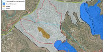
Around 300 dunums of the western part of Yasouf have been inaccessible since 2000. While, at the same time, colonists are allowed to roam the area freely and even use the lands and steal the crops.


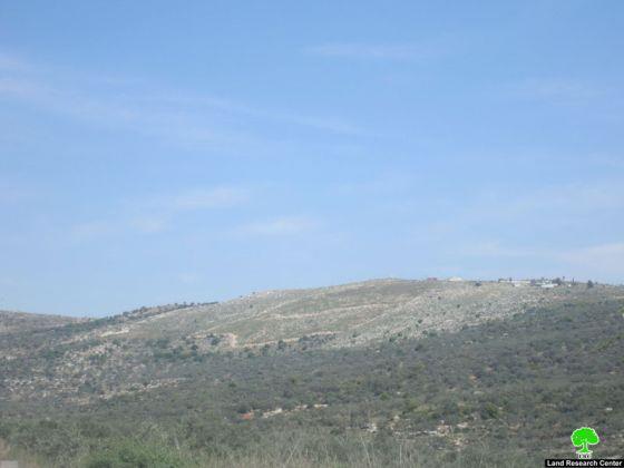
Pictures 1-2


Kfar Tipuah colony:


The colony over looks Zaatara checkpoint which splits the West Bank into two halves. Its total area is 233 dunums and it contains a military camp. The colony was established in 1982, so far, two outpost have been amended to the colony, these are:


  • Rihalim B located to the south of Yasouf


  • New Tipuah to the east of the village.

These two outposts took over around 1000 dunums of Yasouf lands.


The Palestinians Suffering:


The colony has been a source of suffering for Palestinians in the area due to the following:


  1. Blocking agricultural roads.


  2. Uprooting over 1000 olive trees in Tipuah surroundings in order to build a ‘security fence’.


  3. Releasing large numbers of wild boars which caused drastic damage to agricultural lands.


  4. Pumping sewage towards the village and corrupting huge areas of agricultural lands.


  5. Continuous confiscation of lands.


Yasouf:


Yasouf is located 6 km to the north of Salfit. It is inhabited by 1621 people.  The village’s total area is 8550 dunums including 1000 dunums of built up area. 300 dunums are subject to Israeli colonial activities.



Prepared by
 The Land Research Center
LRC
 

Recommended For You

النكبة الفلسطينية في ذكراها الثامنة والسبعين: من التطهير العرقي إلى الإبادة وإعادة هندسة الجغرافيا الفلسطينية 

by arij
May 18, 2026
0
النكبة الفلسطينية في ذكراها الثامنة والسبعين: من التطهير العرقي إلى الإبادة وإعادة هندسة الجغرافيا الفلسطينية 

تحل الذكرى الثامنة والسبعون للنكبة الفلسطينية في ظل واحدة من أكثر المراحل دموية وخطورة في التاريخ الفلسطيني المعاصر، حيث تتداخل آثار النكبة الأصلية لعام 1948 مع واقع الحرب...

Read moreDetails

بين قصرة وترمسعيا: العنف الاستيطاني الاسرائيلي يضرب المجتمع الفلسطيني

by arij
May 6, 2026
0

في الثالث من شهر أيار من العام 2026، شهد مزارعون في عدة قرى في الضفة الغربية المحتلة على مشهد بات مألوفًا وقاسيا في آنٍ واحد: أشجار مثمرة مقطوعة...

Read moreDetails

INFOGRAPHIC: ISRAELI SETTLER VIOLENCE IN 2025

by arij
April 16, 2026
0

INFOGRAPHIC: ISRAELI SETTLER VIOLENCE IN 2025     Prepared by:   The Applied Research Institute – Jerusalem  

Read moreDetails

أدوات غير مباشرة للاستيطان الإسرائيلي في مناطق (أ) و(ب) لإعادة تشكيل الجغرافيا والسيطرة في الضفة الغربية   

by arij
April 16, 2026
0
العدالة المؤجلة ورأي بلا تنفيذ: من قرار المحكمة إلى واقع الضم

منذ توقيع اتفاقيات أوسلو في تسعينيات القرن الماضي، تم تقسيم الضفة الغربية إلى ثلاث مناطق إدارية وأمنية: (أ)، (ب)، و(ج)، بهدف تنظيم المرحلة الانتقالية نحو تسوية نهائية. وبموجب...

Read moreDetails

INFOGRAPHIC: Palestinian Trees – Victims of the Israeli occupation Army & Settler Groups in 2025

by arij
April 16, 2026
0

    INFOGRAPHIC: Palestinian Trees - Victims of the Israeli occupation Army & Settler Groups in 2025 Prepared by:   The Applied Research Institute – Jerusalem  

Read moreDetails
Next Post

ARIJ Daily Report - Thu, 05/04/2012

LATEST NEWS

سلطات الاحتلال الإسرائيلي بصدد الاستيلاء على موقع قبر النبي صموئيل شمال غرب مدينة القدس

سلطات الاحتلال الإسرائيلي بصدد الاستيلاء على موقع قبر النبي صموئيل شمال غرب مدينة القدس

by arij
May 23, 2026
0

........................................................

إقامة منطقة عسكرية عسكرية داخل أراضي (أ) في جنين

إقامة منطقة عسكرية عسكرية داخل أراضي (أ) في جنين

by arij
May 19, 2026
0

........................................................

الآثار كأداة للضم الزاحف: مشروع القانون الإسرائيلي لإعادة هندسة الجغرافيا والهوية في الضفة الغربية

الآثار كأداة للضم الزاحف: مشروع القانون الإسرائيلي لإعادة هندسة الجغرافيا والهوية في الضفة الغربية

by arij
May 23, 2026
0

........................................................

النكبة الفلسطينية في ذكراها الثامنة والسبعين: من التطهير العرقي إلى الإبادة وإعادة هندسة الجغرافيا الفلسطينية 

النكبة الفلسطينية في ذكراها الثامنة والسبعين: من التطهير العرقي إلى الإبادة وإعادة هندسة الجغرافيا الفلسطينية 

by arij
May 18, 2026
0

........................................................

flag_yellow_lowEU-PfP-Logo

This website and its content were initiated in 1993 by the Applied Research Institute – Jerusalem (ARIJ) and the Land Research Center (LRC) with the support from the European Union up until 2023. Since then, the Applied Research Institute – Jerusalem (ARIJ) has taken over the continued development and maintenance of the website. The views expressed remain solely those of ARIJ) and do not necessarily reflect those of the European Union.

© 2026 Copyright | ARIJ | All Rights reserved.

No Result
View All Result
  • Home
  • Settlements
    • New Israeli Settlements
    • Settlement Expansion
  • Israeli Violations
    • Agriculture
    • Confiscation
    • Demolition
    • Environment
    • Eviction of Palestinians
    • Settlers Attacks
  • Bypass Roads
  • Israeli Plans
  • Segregation
    • Checkpoints
    • Closure
    • Separation Plans
  • Military Orders
  • Reports
    • Daily Report
    • Monthly Report
    • Quarterly Report

© 2026 Copyright | ARIJ | All Rights reserved.