• About The Project
  • Palestine in Century
  • Selected Maps
  • Glossary
  • About ARIJ
  • About LRC
  • By Year
    • Case Studies By Year
    • Daily Report By Year
Saturday, May 16, 2026
POICA
No Result
View All Result
  • Home
  • Settlements
    • New Israeli Settlements
    • Settlement Expansion
  • Israeli Violations
    • Agriculture
    • Confiscation
    • Demolition
    • Environment
    • Eviction of Palestinians
    • Settlers Attacks
  • Bypass Roads
  • Israeli Plans
  • Segregation
    • Checkpoints
    • Closure
    • Separation Plans
  • Military Orders
  • Reports
    • Daily Report
    • Monthly Report
    • Quarterly Report
No Result
View All Result
POICA
No Result
View All Result

The Israeli “High Court of Justice” Prevents the Call for Prayers at the Salman Al Farisi Mosque – Nablus Governorate

February 15, 2012
in Settlers Attacks
The Israeli “High Court of Justice” Prevents the Call for Prayers at the Salman Al Farisi Mosque  – Nablus Governorate
Violation: The Israeli “High Court of Justice” prevents the call for prayers at a mosque.
Location: The village of Burin in Nablus Governorate.
Date: February 13, 2012
Perpetrators: The colonists of Yetzhar.
 
The Violation:
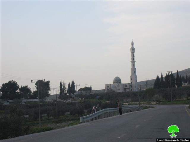
The so-called Israeli “High Court of Justice” issued its ruling on February 13, 2012, that prevented the call of prayers from the Salman Al Farisi Mosque in the village of Burin. The ruling came after the colonists of Yetzhar filed a case against the Mosque under the pretext that the call of prayers is “noisy” and “causes disturbance” to the residents of the colony due to the mosque’s close proximity to it. 
 
It has to be pointed out that the Mosque has received two Stop Work Orders in the year 2010 by the Israeli occupation forces. It, also, was a target of repeated attacks by the colonists. For example, in the past two years the colonists have surrounded the village of Burin more than once with the declared goal of burring down the Mosque. Yet, the alertness of the residents of Burin prevented the colonists from achieving their goal.
 
However, the attempts continue as colonists of Yetzhar have marched a number of times asking the occupation authorities to execute the decision to dismantle and demolish the Mosque. The demolition orders were issued under the pretext that the Mosque was built “without a permit”. The colonists have also contended that “terrorist” attacks were initiated from the Mosque. The targeting of the Mosque goes only to show that the on-going conflict has two dimensions; religious as well as control of the lands and resources.

The head of the Burin Village Council indicated to the Land Research Center (LRC)’s that work started on the Mosque in 2009. It is located in a Palestinian land close to the village’s elementary school and very close to the center of the village. The location of the Mosque and its close proximity to the village’s center dispels the Israeli claim that the Mosque is near the colony or that it forms a threat to it.

It is worth noting that colonists throughout the occupied Palestinian lands have increased the frequency of targeting mosques through burning or writing racist and insulting graffiti on its walls without any iota of respect to other religions. For additional information on the series of attacks against the Mosque, please press here.
 
Burin:
The name of the village stems from the Arabic name bour which means an uncultivated land. Since there are two bour lands (in the east and the west of Nablus), the names became burin. The village is located 2 kilometers away from the Nablus-Ramallah main road. The city of Nablus borders the village from the north, the villages of Oureef and Hiwwara from the south, the villages of Madama and Aseira Al Qibliyya from the west and the villages of Awerta and Adla from the east.
 
It is also located 8 kilometers south of the City of Nablus with a total area of 10,416 dunum. Its built-up area is 335 dunums. Its population is about 3,500. Two Israeli colonies were established on its lands; Brakha (on 205 dunums of Burins’ lands) and Yetzhar (on 105 dunusm of Burins’ lands). 
 
Prepared by
The Land Research Center
LRC


Recommended For You

بين قصرة وترمسعيا: العنف الاستيطاني الاسرائيلي يضرب المجتمع الفلسطيني

by arij
May 6, 2026
0

في الثالث من شهر أيار من العام 2026، شهد مزارعون في عدة قرى في الضفة الغربية المحتلة على مشهد بات مألوفًا وقاسيا في آنٍ واحد: أشجار مثمرة مقطوعة...

Read moreDetails

INFOGRAPHIC: ISRAELI SETTLER VIOLENCE IN 2025

by arij
April 16, 2026
0

INFOGRAPHIC: ISRAELI SETTLER VIOLENCE IN 2025     Prepared by:   The Applied Research Institute – Jerusalem  

Read moreDetails

The West Bank: Between Settler Aggression and Occupation Support – 2025 Highlights

by arij
March 25, 2026
0
The West Bank: Between Settler Aggression and Occupation Support – 2025 Highlights

In the occupied West Bank (oWB), the violence committed by Israeli settlers is no longer a series of isolated, random attacks; it has effectively become a de facto...

Read moreDetails

From a Circle of Violence to a Circle of Impunity: The Structural Empowerment of Settlers

by arij
November 24, 2025
0

Beyond the “Violence Circle” In much of the global discourse, the Israeli settlers on the Palestinians frame the Israeli–Palestinian conflict as a “circle of violence”, a continuous sequence...

Read moreDetails

من دائرة العنف إلى دائرة الإفلات من العقاب: التمكين البنيوي للمستوطنين الإسرائيليين

by arij
November 24, 2025
0
“ما يزيد عن 25 ألف دونم من أراض الزيتون”, موسم الزيتون في فلسطين تحت رهن الأوامر العسكرية

ما وراء "دائرة العنف"              يشهد الصراع الفلسطيني الإسرائيلي منذ عقود متغيرات دراماتيكية، حيث يتجاوز العنف الذي تمارسه اسرائيل على الأرض الحدود التقليدية للمواجهات المسلحة ليصبح جزءا من هيكلية...

Read moreDetails
Next Post
إخطارات بوقف العمل في 6 منازل ببلدة صوريف – محافظة الخليل

إخطارات بوقف العمل في 6 منازل ببلدة صوريف - محافظة الخليل

LATEST NEWS

بين قصرة وترمسعيا: العنف الاستيطاني الاسرائيلي يضرب المجتمع الفلسطيني

by arij
May 6, 2026
0

........................................................

مناطق نفوذ المستوطنات ودورها في إعادة تشكيل الجغرافيا الفلسطينية

مناطق نفوذ المستوطنات ودورها في إعادة تشكيل الجغرافيا الفلسطينية

by arij
April 23, 2026
0

........................................................

التمدد الاستيطاني الإسرائيلي في الضفة الغربية المحتلة وأثره في تقويض مقومات الدولة الفلسطينية

التمدد الاستيطاني الإسرائيلي في الضفة الغربية المحتلة وأثره في تقويض مقومات الدولة الفلسطينية

by arij
April 16, 2026
0

........................................................

INFOGRAPHIC: ISRAELI SETTLER VIOLENCE IN 2025

by arij
April 16, 2026
0

........................................................

flag_yellow_lowEU-PfP-Logo

This website and its content were initiated in 1993 by the Applied Research Institute – Jerusalem (ARIJ) and the Land Research Center (LRC) with the support from the European Union up until 2023. Since then, the Applied Research Institute – Jerusalem (ARIJ) has taken over the continued development and maintenance of the website. The views expressed remain solely those of ARIJ) and do not necessarily reflect those of the European Union.

© 2026 Copyright | ARIJ | All Rights reserved.

No Result
View All Result
  • Home
  • Settlements
    • New Israeli Settlements
    • Settlement Expansion
  • Israeli Violations
    • Agriculture
    • Confiscation
    • Demolition
    • Environment
    • Eviction of Palestinians
    • Settlers Attacks
  • Bypass Roads
  • Israeli Plans
  • Segregation
    • Checkpoints
    • Closure
    • Separation Plans
  • Military Orders
  • Reports
    • Daily Report
    • Monthly Report
    • Quarterly Report

© 2026 Copyright | ARIJ | All Rights reserved.